
Yamagata topographic map
Interactive map
Click on the map to display elevation.
About this map
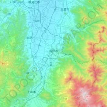
Name: Yamagata topographic map, elevation, terrain.
Location: Yamagata, Yamagata Prefecture, Japan (38.14350 140.17924 38.35199 140.53068)
Average elevation: 458 m
Minimum elevation: 80 m
Maximum elevation: 1,836 m
Other topographic maps
Click on a map to view its topography, its elevation and its terrain.
Mt. Fuji
Japan > Sunto County > Oyama
Mount Fuji (富士山, Fujisan, Japanese: [ɸɯꜜ(d)ʑisaɴ] (listen)), or Fugaku, located on the island of Honshū, is the highest mountain in Japan, with a summit elevation of 3,776.24 m (12,389 ft 3 in). It is the second-highest volcano located on an island in Asia (after Mount Kerinci on the island of…
Average elevation: 3,261 m
Mount Fuji
Japan > Sunto County > Oyama
Mount Fuji (富士山, Fujisan, Japanese: [ɸɯꜜ(d)ʑisaɴ] ) is an active stratovolcano located on the Japanese island of Honshu, with a summit elevation of 3,776.24 m (12,389 ft 3 in). It is the highest mountain in Japan, the second-highest volcano located on an island in Asia (after Mount Kerinci on the…
Average elevation: 3,261 m
Mt. Tate
Japan > Nakaniikawa County > Tateyama
The mountain is primarily composed of granite and gneiss. However, located along the ridge and plateau, about 2 km (1.2 mi) west of the summit, there is a small andesite-dacite stratovolcano. This volcano has an elevation of 2,621 m (8,599 ft) and has minor eruptions, the latest occurring in 1961.
Average elevation: 2,556 m
Mt. Fuji
Japan > Sunto County > Oyama
Mount Fuji (富士山, Fujisan, Japanese: [ɸɯꜜ(d)ʑisaɴ] (listen)), or Fugaku, located on the island of Honshū, is the highest mountain in Japan, with a summit elevation of 3,776.24 m (12,389 ft 3 in). It is the second-highest volcano located on an island in Asia (after Mount Kerinci on the island of…
Average elevation: 3,261 m
Shirakawa
Shirakawa is a mountain village located in far northern Gifu Prefecture, bordering Ishikawa Prefecture and Toyama Prefecture on the Ryōhaku Mountains. Mount Hakusan is the highest elevation at 2,172 metres (7,126 ft). The village's area is 95.7% mountainous forests, and its steep places are characteristic. In…
Average elevation: 667 m
Mount Fuji
Japan > Sunto County > Oyama
Mount Fuji (富士山, Fujisan, Japanese: [ɸɯꜜ(d)ʑisaɴ] ) is an active stratovolcano located on the Japanese island of Honshu, with a summit elevation of 3,776.24 m (12,389 ft 3 in). It is the tallest mountain in Japan, the second-highest volcano located on an island in Asia (after Mount Kerinci on the…
Average elevation: 3,261 m
Mt. Fuji
Japan > Sunto County > Oyama
Mount Fuji (富士山, Fujisan, Japanese: [ɸɯꜜ(d)ʑisaɴ] (listen)), located on the island of Honshū, is the highest mountain in Japan, with a summit elevation of 3,776.24 m (12,389 ft 3 in). It is the second-highest volcano located on an island in Asia (after Mount Kerinci on the island of Sumatra), and…
Average elevation: 3,261 m
Mount Fuji
Japan > Sunto County > Oyama
Mount Fuji (富士山, Fujisan, Japanese: [ɸɯꜜ(d)ʑisaɴ] (listen)), located on the island of Honshū, is an active stratovolcano in Japan, with a summit elevation of 3,776.24 m (12,389 ft 3 in). It is the tallest mountain in Japan, the second-highest volcano located on an island in Asia (after Mount…
Average elevation: 3,261 m
Mount Fuji
Japan > Sunto County > Oyama
Mount Fuji (富士山, Fujisan, Japanese: [ɸɯꜜ(d)ʑisaɴ] (listen)), or Fugaku, located on the island of Honshū, is the highest mountain in Japan, with a summit elevation of 3,776.24 m (12,389 ft 3 in). It is the second-highest volcano located on an island in Asia (after Mount Kerinci on the island of…
Average elevation: 3,261 m