Geolocate

Balearic Islands topographic map

Interactive map

Click on the map to display elevation.

Balearic Islands

Located in the west of the Mediterranean Sea, the Balearic Islands have mostly typical hot-summer Mediterranean climates (Köppen: Csa) with some high altitude areas having a Warm-summer Mediterranean climate (Köppen: Csb) in the island of Majorca. The semi-arid climate (Köppen: BSh and BSk) is also found in the Balearic Islands, mostly on the islands of Ibiza and Formentera but also in the southern part of Majorca.

Wikipedia (CC-BY-SA 3.0)

About this map

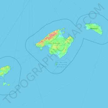
Name: Balearic Islands topographic map, elevation, terrain.

Location: Balearic Islands, Spain (38.64045 1.15727 40.09459 4.32803)

Average elevation: 9 m

Minimum elevation: -4 m

Maximum elevation: 1,317 m

Other topographic maps

Click on a map to view its topography, its elevation and its terrain.

Mairena

Spain > Andalusia > Partido Judicial de Órgiva > Nevada

Average elevation: 1,037 m

Menorca

Spain > Balearic Islands > Es Migjorn Gran

Average elevation: 9 m

Torrox Park

Spain > Andalusia > La Axarquía > Torrox

Average elevation: 72 m

Abi

Spain > Aragon > Seira

Average elevation: 1,135 m

Gabás

Spain > Aragon > Bisaurri

Average elevation: 1,291 m

Panes

Spain > Asturias > Peñamellera Baja

Average elevation: 196 m

San Miguel de Luena

Spain > Cantabria > Luena

Average elevation: 642 m

Cortina

Spain > Asturias > Oviedo

Average elevation: 309 m

Arenas de Cabrales

Spain > Asturias > Cabrales

Average elevation: 374 m

Allén del Hoyo

Spain > Cantabria > Valderredible

Average elevation: 910 m

Les Potes

Spain > Asturias > Somiedo > Braña el Tornu

Average elevation: 988 m

Maroma

Spain > Andalusia > La Axarquía > Canillas de Aceituno

La Maroma, also known as Tejeda, at an altitude of 2069 m, is the highest peak of the Sierra de Tejeda, Penibaetic System, Spain. The summit is located in the region of Axarquía on the border between the provinces of Granada and Málaga.

Average elevation: 1,706 m

Valdorria

Spain > Castile and León > Valdepiélago

Average elevation: 1,380 m

Valle de Tena

Spain > Aragon > Alto Gállego > Búbal

Average elevation: 1,313 m

Su

Spain > Catalonia > Solsonès

Su, belongs to the municipality of Riner, in the comarca of Solsonès, vegueria of Comarques Centrals (Catalonia). Su is situated at an elevation of 726 meters above sea level.

Average elevation: 738 m

Costa Brava

Spain

Average elevation: 247 m

La Llave

Spain > Asturias > Samartín del Rei Aurelio

Average elevation: 416 m

Camp de Mar

Spain > es Camp de Mar

Average elevation: 41 m

Palomares

Spain > Andalusia

Average elevation: 23 m

Beget

Spain > Catalonia > Ripollès > Camprodon

Average elevation: 761 m

Río Quintanilla

Spain > Castile and León

Average elevation: 783 m

El Bujeo

Spain > Andalusia > Comarca de Loja > Loja

Average elevation: 605 m

Valderoy

Spain > Aragon > Comunidad de Calatayud > Ateca

Average elevation: 659 m

Barranco de la Virgen

Spain > Aragon > Zaragoza > Zaragoza

Average elevation: 365 m

Malpica de Arba

Spain > Aragon > Cinco Villas > Biota

Average elevation: 610 m

Mirador de La Rambleta

Spain > La Orotava

Average elevation: 3,166 m

Badaguás

Spain > Aragon > Jacetania > Jaca

Average elevation: 1,100 m

Los Vagos

Spain > Castile-La Mancha > Alcalá de la Vega

Average elevation: 1,185 m

Hecho

Spain > Aragon > Jacetania > Valle de Hecho

Average elevation: 967 m

Cerro de Santa Isabel

Spain > Aragon > Maestrazgo > Castellote

Average elevation: 788 m

Lavizán

Spain > Cantabria > Valderredible > Revelillas

Average elevation: 940 m

Los Pedrones

Spain > Valencian Community > Requena

Average elevation: 688 m

Lookout of Jozarcu

Spain > Cantabria > Peñarrubia > Linares > Piñeres

Average elevation: 487 m

Pla de la Calma

Spain > Catalonia > Osona > el Brull

Average elevation: 1,111 m

O Cotiño

Spain > Galicia > Vigo > A Portela de Puxeiros

Average elevation: 198 m

Rastro la Cueva

Spain > Rioja > Lagunilla del Jubera

Average elevation: 494 m

Los Vagos

Spain > Castile-La Mancha > Alcalá de la Vega

Average elevation: 1,185 m

As Vendas da Barreira

Spain > Galicia > Verín > Riós

Average elevation: 802 m

Hecho

Spain > Aragon > Jacetania > Valle de Hecho

Average elevation: 967 m

Fuente Álamo

Spain > Andalusia > Alcalá la Real

Average elevation: 700 m

Cananda

Spain > Asturias > Cabrales

Average elevation: 781 m

Bellfort

Spain > Catalonia > Noguera > la Baronia de Rialb

Average elevation: 580 m

Santinos

Spain > Castile and León > Tudela de Duero

Average elevation: 707 m

Bricia

Spain > Castile and León > Alfoz de Bricia

Average elevation: 979 m

Alhambra

Spain > Andalusia > Partido Judicial de Granada > Granada

During the reign of the Nasrid Dynasty, the Alhambra was transformed into a palatine city, complete with an irrigation system composed of aqueducts and water channels that provided water for the complex and for other nearby countryside palaces such as the Generalife. Previously, the old fortresses on the hill…

Average elevation: 759 m

Pozacas

Spain > Asturias > Grandas de Salime > Silvañá

Average elevation: 758 m

Son Blanc

Spain > Balearic Islands > Menorca > Ciutadella > sa Caleta

Average elevation: 11 m

Es Corrals

Spain > Balearic Islands

Average elevation: 8 m

Presa de Almendra

Spain > Castile and León > Almendra

Average elevation: 699 m

Navatejera

Spain > Castile and León > Villaquilambre

Average elevation: 868 m

Troncéu

Spain > Asturias > Cudillero

Average elevation: 190 m

San Juan

Spain > Valencian Community > Villena > La Puentecilla

Average elevation: 495 m

La Restinga

Spain > El Pinar de El Hierro

Average elevation: 50 m

El Coto

Spain > Castile and León > Cuadros

Average elevation: 917 m

O Porto de Santa Cruz

Spain > Galicia > A Coruña

Average elevation: 40 m

Alhambra

Spain > Andalusia > Partido Judicial de Granada > Granada

During the reign of the Nasrid Dynasty, the Alhambra was transformed into a palatine city, complete with an irrigation system composed of aqueducts and water channels that provided water for the complex and for other nearby countryside palaces such as the Generalife. Previously, the old fortresses on the hill…

Average elevation: 759 m

O Picón

Spain > Galicia > Ortegal > Ortigueira

Average elevation: 36 m

El Abiar

Spain > Andalusia > Los Vélez > Vélez-Blanco

Average elevation: 994 m

San Juan

Spain > Valencian Community > Villena > La Puentecilla

Average elevation: 495 m

Bel-Air

Spain > Andalusia > Costa del Sol Occidental > Estepona

Average elevation: 35 m

Rícmar

Spain > Andalusia > Costa del Sol Occidental > Marbella

Average elevation: 35 m

La Presidenta

Spain > Catalonia > Baix Llobregat > Collbató

Average elevation: 753 m

Campillo del Moro

Spain > Andalusia

Average elevation: 140 m

La Maliciosa

Spain > Community of Madrid > Navacerrada

La Maliciosa is one of the most important and highest mountains of the Sierra de Guadarrama, a mountainous formation belonging to the Sistema Central. It has an altitude of 2227m above sea level and is located in the northwest of the Community of Madrid, in Spain, rising between La Pedriza, which lies to the…

Average elevation: 1,856 m

Baua

Spain > Asturias > Ribeseya

Average elevation: 322 m

Rubalcaba

Spain > Cantabria > Liérganes

Average elevation: 287 m

Manacor

Spain > Balearic Islands > Llevant

Average elevation: 100 m

Churra

Spain > Region of Murcia > Alto Guadalentín > Lorca

Average elevation: 332 m

Cabanes de la Serra

Spain > Catalonia > Ripollès > Setcases

Average elevation: 1,661 m

El Mesegar

Spain > Castile and León > Olmedo

Average elevation: 740 m

Los Yesos

Spain > Andalusia > Tabernas

Average elevation: 532 m

Lois

Spain > Castile and León > Crémenes

Average elevation: 1,466 m

Monticelo

Spain > Asturias > Vegadeo

Average elevation: 532 m

Cala Vedella

Spain > Balearic Islands > Ibiza

Average elevation: 62 m

La Ral

Spain > Aragon > Campo de Belchite > Azuara

Average elevation: 674 m