
Muskingum County topographic map
Interactive map
Click on the map to display elevation.
About this map
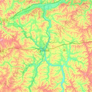
Name: Muskingum County topographic map, elevation, terrain.
Location: Muskingum County, Ohio, United States (39.75565 -82.23405 40.16663 -81.69081)
Average elevation: 274 m
Minimum elevation: 203 m
Maximum elevation: 382 m
Other topographic maps
Click on a map to view its topography, its elevation and its terrain.
French Park
United States > Ohio > Hamilton County > Amberley Village > Rolling Knolls Estate
Average elevation: 235 m
Pine Ridge Trailer Park
United States > Ohio > Lorain County > North Ridgeville
Average elevation: 228 m
Nature Center at The Summit
United States > Ohio > Hamilton County > Cincinnati
Average elevation: 173 m
Columbus
United States > Ohio > Franklin County > Columbus
The confluence of the Scioto and Olentangy rivers is just north-west of Downtown Columbus. Several smaller tributaries course through the Columbus metropolitan area, including Alum Creek, Big Walnut Creek, and Darby Creek. Columbus is considered to have relatively flat topography thanks to a large glacier that…
Average elevation: 255 m
Cincinnati
United States > Ohio > Hamilton County
Cincinnati has several standard modes of transportation including sidewalks, roads, public transit, bicycle paths and airports. The city's hills preclude the regular street grid common to many cities built up in the 19th century, and outside of the downtown basin, regular street grids are rare except for in…
Average elevation: 225 m