
Flanders topographic map
Interactive map
Click on the map to display elevation.
About this map
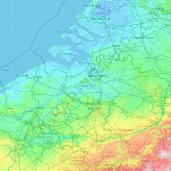
Name: Flanders topographic map, elevation, terrain.
Location: Flanders, Belgium (50.68738 2.54136 51.50511 5.91111)
Average elevation: 61 m
Minimum elevation: -7 m
Maximum elevation: 641 m
Other topographic maps
Click on a map to view its topography, its elevation and its terrain.
Battle of Waterloo
Belgium > Walloon Brabant > Waterloo
Waterloo was the decisive engagement of the Waterloo Campaign and Napoleon's last. According to Wellington, the battle was "the nearest-run thing you ever saw in your life". Napoleon abdicated four days later, and coalition forces entered Paris on 7 July. The defeat at Waterloo ended Napoleon's rule as Emperor…
Average elevation: 121 m
Boonwijk
Belgium > East Flanders > Dendermonde > Dendermonde > Sint-Gillis-bij-Dendermonde
Average elevation: 4 m
Cité du Champ de l'Ange
Belgium > Hainaut > Soignies > Braine-le-Comte > Petit-Roeulx-Lez-Braine
Average elevation: 81 m
Pré Delcourt
Belgium > Walloon Brabant > Nivelles > Chaumont-Gistoux > Chaumont
Average elevation: 127 m