
Jammu and Kashmir topographic map
Interactive map
Click on the map to display elevation.
About this map
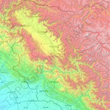
Name: Jammu and Kashmir topographic map, elevation, terrain.
Location: Jammu and Kashmir, India (32.27636 73.75003 34.78714 76.78032)
Average elevation: 2,430 m
Minimum elevation: 208 m
Maximum elevation: 7,015 m
Jammu and Kashmir is home to several valleys such as the Kashmir Valley, Tawi Valley, Chenab Valley, Poonch Valley, Sind Valley, and Lidder Valley. The Kashmir valley is 100 km (62 mi) wide and 15,520.3 km2 (5,992.4 sq mi) in area. The Himalayas divide the Kashmir valley from the Tibetan plateau while the Pir Panjal range, which encloses the valley from the west and the south, separates it from the Punjab Plain of the Indo-Gangetic Plain. Along the northeastern flank of the Valley runs the main range of the Himalayas. This valley has an average height of 1,850 metres (6,070 ft) above sea-level, but the surrounding Pir Panjal range has an average elevation of 10,000 feet (3,000 m). The Jhelum River is the major Himalayan river which flows through the Kashmir valley. The southern Jammu region is mostly mountainous, with the Shivaliks, the middle and the great Himalayas running parallel to each other in a southeast-northwest direction. A narrow southwestern strip constitutes fertile plains. The Chenab, Tawi and Ravi are important rivers flowing through the Jammu region.
Other topographic maps
Click on a map to view its topography, its elevation and its terrain.
Chennai
India > Tamil Nadu > Chennai
Chennai, Chennai District, Tamil Nadu, India
Average elevation: 8 m
Bengaluru
India > Karnataka > Bangalore North
Bengaluru, Bangalore North, Bengaluru Urban District, Karnataka, India
Average elevation: 881 m
3d
India > Rajasthan > Ganganagar Tehsil > 1 LNP
3d, 1 LNP, Ganganagar Tehsil, Sri Ganganagar District, Rajasthan, India
Average elevation: 178 m
Lucknow
India > Uttar Pradesh > Lucknow
Lucknow, Lucknow District, Uttar Pradesh, 226027, India
Average elevation: 120 m
Kolkata
Kolkata, Kolkata District, West Bengal, 700073, India
Average elevation: 5 m
Mysuru
India > Karnataka > Mysuru taluk
Mysuru, Mysuru taluk, Mysuru District, Karnataka, 570001, India
Average elevation: 727 m
Whitefield
India > Karnataka > Bangalore East > Bengaluru
Whitefield, Bengaluru, Bangalore East, Bengaluru Urban District, Karnataka, 560066, India
Average elevation: 875 m
Pune
India > Maharashtra > Pune City > Pune
Pune, Pune City, Pune District, Maharashtra, 411001, India
Average elevation: 641 m
Thoothukudi
India > Tamil Nadu > Thoothukkudi
Thoothukudi, Thoothukkudi, Thoothukudi District, Tamil Nadu, 628001, India
Average elevation: 10 m
Hanagal taluk
Hanagal taluk, Haveri District, Karnataka, India
Average elevation: 571 m
Bachupally mandal
Bachupally mandal, Medchal–Malkajgiri District, Telangana, 500090, India
Average elevation: 593 m
Malihabad
Malihabad, Lucknow District, Uttar Pradesh, India
Average elevation: 127 m
Western Ghats
Western Ghats, Idukki, Kerala, 685614, India
Average elevation: 2,225 m
Panaiyur
India > Tamil Nadu > Mannargudi
Panaiyur, Mannargudi, Thiruvarur District, Tamil Nadu, 614717, India
Average elevation: 7 m
Kallikudi
India > Tamil Nadu > Srirangam
Kallikudi, Srirangam, Tiruchirappalli District, Tamil Nadu, 620102, India
Average elevation: 83 m
Palghar
India > Maharashtra > Palghar Taluka
Palghar, Palghar Taluka, Palghar District, Maharashtra, 401400, India
Average elevation: 19 m
Singpur
India > Madhya Pradesh > Gadarwara Tahsil
Singpur, Gadarwara Tahsil, Narsinghpur District, Madhya Pradesh, India
Average elevation: 366 m
Shamshabad Reserved Forest
India > Madhya Pradesh > Vidisha Tahsil > Hinotiya
Shamshabad Reserved Forest, Hinotiya, Vidisha Tahsil, Vidisha District, Madhya Pradesh, India
Average elevation: 469 m
Jaisalmer Tehsil
Jaisalmer Tehsil, Jaisalmer District, Rajasthan, India
Average elevation: 140 m
Mekkunnu
India > Kerala > Thalassery
Mekkunnu, Thalassery, Kannur District, Kerala, 670675, India
Average elevation: 19 m
Thiruvananthapuram
India > Kerala > Thiruvananthapuram
Thiruvananthapuram, Thiruvananthapuram District, Kerala, 695001, India
Average elevation: 33 m
Srinagar
India > Jammu and Kashmir > Srinagar (South)
Srinagar, Srinagar (South), Srinagar District, Jammu and Kashmir, 190001, India
Average elevation: 1,805 m
Patna
India > Bihar > Patna Rural
Patna, Patna Rural, Patna District, Bihar, 800001, India
Average elevation: 51 m