
Kent topographic map
Interactive map
Click on the map to display elevation.
About this map
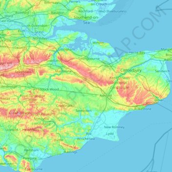
Name: Kent topographic map, elevation, terrain.
Location: Kent, South East, England, United Kingdom (50.91048 0.03352 51.48227 1.45177)
Average elevation: 37 m
Minimum elevation: -3 m
Maximum elevation: 263 m
Kent was also the location of the largest number of art schools in the country during the nineteenth century, estimated by the art historian David Haste, to approach two hundred. This is believed to be the result of Kent being a front line county during the Napoleonic Wars. At this time, before the invention of photography, draughtsmen were used to draw maps and topographical representations of the fields of battle, and after the wars ended many of these settled permanently in the county in which they had been based. Once the idea of art schools had been established, even in small towns in Kent, the tradition continued, although most of the schools were very small one man operations, each teaching a small number of daughters of the upper classes how to draw and make watercolour paintings. Nonetheless, some of these small art schools developed into much larger organisations, including Canterbury College of Art, founded by Thomas Sidney Cooper in 1868, which is today the University for the Creative Arts.
Other topographic maps
Click on a map to view its topography, its elevation and its terrain.
London
United Kingdom > England > London
London, Greater London, England, SW1A 2DX, United Kingdom
Average elevation: 42 m
Bristol
United Kingdom > England > City of Bristol
Bristol, City of Bristol, West of England, England, United Kingdom
Average elevation: 55 m
Nottingham
United Kingdom > England > Nottinghamshire
Nottingham, England, United Kingdom
Average elevation: 56 m
Portsmouth
United Kingdom > England > Hampshire > Portsmouth
Portsmouth, Hampshire, South East England, England, PO1 5QH, United Kingdom
Average elevation: 28 m
Brighton
United Kingdom > England > Brighton and Hove
Brighton, Brighton and Hove, England, United Kingdom
Average elevation: 64 m
Greater Manchester
Greater Manchester, England, United Kingdom
Average elevation: 141 m
Bath
United Kingdom > England > Bath and North East Somerset
Bath, Bath and North East Somerset, West of England, England, United Kingdom
Average elevation: 100 m
South Downs National Park
United Kingdom > England > West Sussex
South Downs National Park, West Sussex, England, United Kingdom
Average elevation: 54 m
Grimsby
United Kingdom > England > North East Lincolnshire
Grimsby, North East Lincolnshire, England, DN31 1NR, United Kingdom
Average elevation: 6 m
Gloucester
United Kingdom > England > Gloucestershire
Gloucester, Gloucestershire, England, United Kingdom
Average elevation: 36 m
Birmingham
Birmingham, West Midlands Combined Authority, England, United Kingdom
Average elevation: 138 m
East of England
East of England, England, United Kingdom
Average elevation: 39 m
Almondsbury
United Kingdom > England > South Gloucestershire
Almondsbury, South Gloucestershire, West of England, England, BS32 4DT, United Kingdom
Average elevation: 47 m
London
London, Greater London, England, United Kingdom
Average elevation: 66 m
Stamford
United Kingdom > England > Lincolnshire > South Kesteven
Stamford, South Kesteven, Lincolnshire, England, PE9 2AJ, United Kingdom
Average elevation: 52 m
Glastonbury
United Kingdom > England > Glastonbury
Glastonbury, Somerset, South West England, England, BA6 9, United Kingdom
Average elevation: 14 m
Sheffield
Sheffield, South Yorkshire, England, United Kingdom
Average elevation: 168 m
Reading
United Kingdom > England > West Berkshire > Reading
Reading, West Berkshire, South East England, England, RG1 1DA, United Kingdom
Average elevation: 56 m
Lake District National Park
Lake District National Park, England, United Kingdom
Average elevation: 206 m
Keswick
United Kingdom > England > Keswick
Keswick, Cumbria, North West England, England, CA12 5JF, United Kingdom
Average elevation: 223 m
Eastbourne
United Kingdom > England > East Sussex
Eastbourne, East Sussex, England, United Kingdom
Average elevation: 36 m
Norwich
United Kingdom > England > Norfolk
Norwich, Norfolk, England, United Kingdom
Average elevation: 28 m
Kingston upon Thames
Kingston upon Thames, Greater London, England, KT1 1JS, United Kingdom
Average elevation: 19 m
Bedford
United Kingdom > England > Bedford
Bedford, England, MK40 1SU, United Kingdom
Average elevation: 37 m
Plymouth
United Kingdom > England > Devon > Plymouth
Plymouth, Devon, South West England, England, PL1 1HH, United Kingdom
Average elevation: 81 m
South East England
South East England, England, United Kingdom
Average elevation: 69 m
Silwood Park
United Kingdom > England > Royal Borough of Windsor and Maidenhead > Beggar's Bush
Silwood Park, Virginia Water Lodge, Sunninghill and Ascot, Beggar's Bush, Royal Borough of Windsor and Maidenhead, England, SL5 7QE, United Kingdom
Average elevation: 61 m
Warminster
United Kingdom > England > Wiltshire
Warminster, Wiltshire, England, United Kingdom
Average elevation: 143 m
Hampshire
Hampshire, South East, England, United Kingdom
Average elevation: 73 m
Halifax
United Kingdom > England > Calderdale
Halifax, Calderdale, West Yorkshire, England, HX1 1TH, United Kingdom
Average elevation: 195 m
Dorking
United Kingdom > England > Surrey > Mole Valley
Dorking, Mole Valley, Surrey, England, United Kingdom
Average elevation: 80 m
Chichester
United Kingdom > England > West Sussex
Chichester, West Sussex, England, United Kingdom
Average elevation: 57 m
Newcastle upon Tyne
Newcastle upon Tyne, North of Tyne, England, United Kingdom
Average elevation: 57 m
Appleton Wiske
United Kingdom > England > North Yorkshire
Appleton Wiske, North Yorkshire, England, United Kingdom
Average elevation: 54 m
Smith's Green
United Kingdom > England > Cheshire East > Barthomley
Smith's Green, Barthomley, Cheshire East, England, CW2 5NU, United Kingdom
Average elevation: 80 m
Alwalton
United Kingdom > England > Cambridgeshire > Huntingdonshire
Alwalton, Huntingdonshire, Cambridgeshire, Cambridgeshire and Peterborough, England, United Kingdom
Average elevation: 25 m
The Cotswolds National Landscape
United Kingdom > England > Gloucestershire
The Cotswolds National Landscape, Gloucestershire, West of England, England, United Kingdom
Average elevation: 109 m
West Midlands
United Kingdom > England > Warwickshire
West Midlands, Warwickshire, West Midlands Combined Authority, England, United Kingdom
Average elevation: 113 m
Hemel Hempstead
United Kingdom > England > Hertfordshire > Dacorum
Hemel Hempstead, Dacorum, Hertfordshire, England, HP1 1EW, United Kingdom
Average elevation: 130 m