
Make a donation
Gear up for your next adventure:
As an Amazon Associate, this site earns from qualifying purchases at no extra cost to you.
Takatsuki topographic map
Click on the map to display elevation.
Make a donation
Gear up for your next adventure:
As an Amazon Associate, this site earns from qualifying purchases at no extra cost to you.
Takatsuki
Takatsuki is located in the northeastern part of Osaka Prefecture. The city is approximately 10.4 kilometers east-to-west and 22.7 kilometers north-to-south. The north is bounded by the Hokusetsu mountain range and the south by the Yodo River, and the topography is high in the north and low in the south. The highest elevation in the city is 678.7 meters at Mt. Ponpon, and the lowest elevation is 3.3 meters at the Yodogawa riverbed in Hashiramoto. Takatsuki is 21.2 kilometers from central Osaka and 21.6 kilometers from central Kyoto. Two-thirds of the city area is zoned as urbanization control areas where development is restricted, and much of the forest and farmland remains.
Make a donation
Gear up for your next adventure:
As an Amazon Associate, this site earns from qualifying purchases at no extra cost to you.
About this map
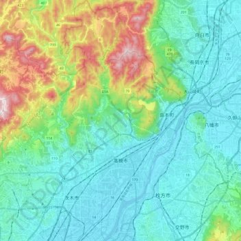
Name: Takatsuki topographic map, elevation, terrain.
Location: Takatsuki, Osaka Prefecture, Japan (34.78051 135.55719 34.97676 135.67264)
Average elevation: 154 m
Minimum elevation: -3 m
Maximum elevation: 667 m
Make a donation
Gear up for your next adventure:
As an Amazon Associate, this site earns from qualifying purchases at no extra cost to you.
Other topographic maps
Click on a map to view its topography, its elevation and its terrain.
Mount Fuji
Japan > Sunto County > Oyama
Mount Fuji (富士山, Fujisan, Japanese: [ɸɯꜜ(d)ʑisaɴ] (listen)), or Fugaku, located on the island of Honshū, is the highest mountain in Japan, with a summit elevation of 3,776.24 m (12,389 ft 3 in). It is the second-highest volcano located on an island in Asia (after Mount Kerinci on the island of…
Average elevation: 3,264 m
Mount Fuji
Japan > Sunto County > Oyama
Mount Fuji (富士山, Fujisan, Japanese: [ɸɯꜜ(d)ʑisaɴ] (listen)), or Fugaku, located on the island of Honshū, is the highest mountain in Japan, with a summit elevation of 3,776.24 m (12,389 ft 3 in). It is the second-highest volcano located on an island in Asia (after Mount Kerinci on the island of…
Average elevation: 3,261 m
Make a donation
Gear up for your next adventure:
As an Amazon Associate, this site earns from qualifying purchases at no extra cost to you.
Make a donation
Gear up for your next adventure:
As an Amazon Associate, this site earns from qualifying purchases at no extra cost to you.
Make a donation
Gear up for your next adventure:
As an Amazon Associate, this site earns from qualifying purchases at no extra cost to you.
Mount Aso
Japan > Aso County > Minamiaso
With an elevation of 1,143 metres (3,750 ft)., Mount Aso has a climate that falls as humid continental (Köppen climate classification "Dfb"), with warm summers and cold winters. Precipitation is high throughout the year, which brings the area to have borderline subtropical characteristics as well. It is…
Average elevation: 1,254 m
Make a donation
Gear up for your next adventure:
As an Amazon Associate, this site earns from qualifying purchases at no extra cost to you.
Make a donation
Gear up for your next adventure:
As an Amazon Associate, this site earns from qualifying purchases at no extra cost to you.
Mount Fuji
Japan > Sunto County > Oyama
Mount Fuji (富士山・富士の山, Fujisan, Fuji no Yama) is an active stratovolcano located on the Japanese island of Honshu, with a summit elevation of 3,776.24 m (12,389 ft 3 in). It is the highest mountain in Japan, the second-highest volcano on any Asian island (after Mount Kerinci on the Indonesian…
Average elevation: 3,264 m
Make a donation
Gear up for your next adventure:
As an Amazon Associate, this site earns from qualifying purchases at no extra cost to you.
Mount Tateshina
It has an elevation of 2,530 m (8,301 ft). This mountain is one of the 100 Famous Japanese Mountains.
Average elevation: 2,082 m
Make a donation
Gear up for your next adventure:
As an Amazon Associate, this site earns from qualifying purchases at no extra cost to you.
Make a donation
Gear up for your next adventure:
As an Amazon Associate, this site earns from qualifying purchases at no extra cost to you.
Mount Fuji
Japan > Sunto County > Oyama
Mount Fuji (富士山・富士の山, Fujisan, Fuji no Yama) is an active stratovolcano located on the Japanese island of Honshu, with a summit elevation of 3,776.24 m (12,389 ft 3 in). It is the highest mountain in Japan, the second-highest volcano on any Asian island (after Mount Kerinci on the Indonesian…
Average elevation: 3,261 m
Shirakawa
Shirakawa is a mountain village located in far northern Gifu Prefecture, bordering Ishikawa Prefecture and Toyama Prefecture on the Ryōhaku Mountains. Mount Hakusan is the highest elevation at 2,172 metres (7,126 ft). The village's area is 95.7% mountainous forests, and its steep places are characteristic. In…
Average elevation: 667 m
Make a donation
Gear up for your next adventure:
As an Amazon Associate, this site earns from qualifying purchases at no extra cost to you.
Make a donation
Gear up for your next adventure:
As an Amazon Associate, this site earns from qualifying purchases at no extra cost to you.
Make a donation
Gear up for your next adventure:
As an Amazon Associate, this site earns from qualifying purchases at no extra cost to you.
Mount Chōkai
Japan > Akumi County > Yuza
Mount Chōkai is shared by two municipalities in Akita Prefecture and four municipalities Yamagata Prefecture; however, its peak is located in Yuza, on the Yamagata side of the border. It is therefore the highest peak in Yamagata, and the second highest in the Tōhoku region after Mt. Hiuchigatake (altitude…
Average elevation: 1,808 m
Make a donation
Gear up for your next adventure:
As an Amazon Associate, this site earns from qualifying purchases at no extra cost to you.
Make a donation
Gear up for your next adventure:
As an Amazon Associate, this site earns from qualifying purchases at no extra cost to you.
Make a donation
Gear up for your next adventure:
As an Amazon Associate, this site earns from qualifying purchases at no extra cost to you.
Mount Fuji
Japan > Sunto County > Oyama
Mount Fuji (富士山, Fujisan, Japanese: [ɸɯꜜ(d)ʑisaɴ] ) is an active stratovolcano located on the Japanese island of Honshu, with a summit elevation of 3,776.24 m (12,389 ft 3 in). It is the highest mountain in Japan, the second-highest volcano located on an island in Asia (after Mount Kerinci on the…
Average elevation: 3,264 m
Make a donation
Gear up for your next adventure:
As an Amazon Associate, this site earns from qualifying purchases at no extra cost to you.
Make a donation
Gear up for your next adventure:
As an Amazon Associate, this site earns from qualifying purchases at no extra cost to you.
Make a donation
Gear up for your next adventure:
As an Amazon Associate, this site earns from qualifying purchases at no extra cost to you.
Make a donation
Gear up for your next adventure:
As an Amazon Associate, this site earns from qualifying purchases at no extra cost to you.
Make a donation
Gear up for your next adventure:
As an Amazon Associate, this site earns from qualifying purchases at no extra cost to you.
Mt. Tate
Japan > Nakaniikawa County > Tateyama
The mountain is primarily composed of granite and gneiss. However, located along the ridge and plateau, about 2 km (1.2 mi) west of the summit, there is a small andesite-dacite stratovolcano. This volcano has an elevation of 2,621 m (8,599 ft) and has minor eruptions, the latest occurring in 1961.
Average elevation: 2,556 m
Make a donation
Gear up for your next adventure:
As an Amazon Associate, this site earns from qualifying purchases at no extra cost to you.
Make a donation
Gear up for your next adventure:
As an Amazon Associate, this site earns from qualifying purchases at no extra cost to you.
Make a donation
Gear up for your next adventure:
As an Amazon Associate, this site earns from qualifying purchases at no extra cost to you.
Make a donation
Gear up for your next adventure:
As an Amazon Associate, this site earns from qualifying purchases at no extra cost to you.
Shirakawa
Shirakawa is a mountain village located in far northern Gifu Prefecture, bordering Ishikawa Prefecture and Toyama Prefecture on the Ryōhaku Mountains. Mount Hakusan is the highest elevation at 2,172 metres (7,126 ft). The village's area is 95.7% mountainous forests, and its steep places are characteristic. In…
Average elevation: 667 m
Make a donation
Gear up for your next adventure:
As an Amazon Associate, this site earns from qualifying purchases at no extra cost to you.
Mount Fuji
Japan > Sunto County > Oyama
Mount Fuji (富士山, Fujisan, Japanese: [ɸɯꜜ(d)ʑisaɴ] ) is an active stratovolcano located on the Japanese island of Honshu, with a summit elevation of 3,776.24 m (12,389 ft 3 in). It is the tallest mountain in Japan, the second-highest volcano located on an island in Asia (after Mount Kerinci on the…
Average elevation: 3,261 m
Make a donation
Gear up for your next adventure:
As an Amazon Associate, this site earns from qualifying purchases at no extra cost to you.