
Make a donation
Gear up for your next adventure:
As an Amazon Associate, this site earns from qualifying purchases at no extra cost to you.
Helmand Province topographic map
Click on the map to display elevation.
Make a donation
Gear up for your next adventure:
As an Amazon Associate, this site earns from qualifying purchases at no extra cost to you.
About this map
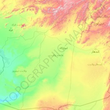
Name: Helmand Province topographic map, elevation, terrain.
Location: Helmand Province, Afghanistan (29.37729 62.55310 33.36983 65.37155)
Average elevation: 1,089 m
Minimum elevation: 452 m
Maximum elevation: 3,981 m
Make a donation
Gear up for your next adventure:
As an Amazon Associate, this site earns from qualifying purchases at no extra cost to you.
Other topographic maps
Click on a map to view its topography, its elevation and its terrain.
Farah
Afghanistan > Farah Province > Farah
Sitting at an elevation of approximately 650 m (2,130 ft) above sea level, Farah is one of the largest cities in western Afghanistan. It is located on the Farah River, roughly 125 km (78 mi) from the Afghanistan–Iran border. The city has a land area of 29 km2 (11 sq mi) or 2,949 ha (7,290 acres). In 2025…
Average elevation: 697 m
Taloqan
Afghanistan > Takhar Province > Taluqan District
Taloqan sits at an altitude of 876 m (2,874 ft) above sea level, and has a land area of 107 km2 (41 sq mi) with 28,691 dwelling units in it. The city is administratively divided into 6 city districts (nahias). There is a major road that passes through the city, linking it with nearby Kunduz in the west and…
Average elevation: 1,069 m
Make a donation
Gear up for your next adventure:
As an Amazon Associate, this site earns from qualifying purchases at no extra cost to you.
Bamian
Afghanistan > Bamyan Province > Bamyan
Bamyan sits at an altitude of about 8,366 ft (2,550 m) above sea level. The municipality is divided into four districts and has a total land area of 35 km2 (14 sq mi). There are about 4,435 dwelling units in the city. Bamyan marked the most westerly point of Buddhist expansion and was a crucial hub of trade…
Average elevation: 3,174 m
Make a donation
Gear up for your next adventure:
As an Amazon Associate, this site earns from qualifying purchases at no extra cost to you.
Balkh
Afghanistan > Balkh Province > Balkh
Historically, the site of present-day Balkh was held in considerably high regard due to its religious and political significance in Ariana. A hub of Zoroastrianism and Buddhism, the ancient city was also known to the Persians as Zariaspa and to the Greeks as Bactra, giving its name to Bactria. As such, it was…
Average elevation: 348 m
Make a donation
Gear up for your next adventure:
As an Amazon Associate, this site earns from qualifying purchases at no extra cost to you.
Ghazni
Ghazni's climate is transitional between a cold semi-arid climate (Köppen climate classification BSk) and a hot-summer humid continental climate (Dsa). It has cold, snowy winters and warm, dry summers. Precipitation is low and mostly falls in winter (as snow) and spring (as rain). Winters are very cold, with…
Average elevation: 2,341 m
Kandahar
Afghanistan > Kandahar Province > Kandahar
Kandahar is a city in Afghanistan, located in the south of the country on Arghandab River, at an elevation of 1,010 m (3,310 ft). It is Afghanistan's second largest city, after Kabul, with a population of about 614,118 in 2015. It is the capital of Kandahar Province and the centre of the larger cultural region…
Average elevation: 1,048 m
Make a donation
Gear up for your next adventure:
As an Amazon Associate, this site earns from qualifying purchases at no extra cost to you.
Bamian
Afghanistan > Bamyan Province > Bamyan
Bamyan (Pashto, Dari: بامیان), also spelled Bamian or Bamiyan, is the capital of Bamyan Province in central Afghanistan. Its population of approximately 100,000 people makes it the largest city in the Hazarajat region of Afghanistan. Bamyan is at an altitude of about 8,366 feet (2,550 m) above sea level.…
Average elevation: 3,174 m
Make a donation
Gear up for your next adventure:
As an Amazon Associate, this site earns from qualifying purchases at no extra cost to you.
Kabul
Afghanistan > Kabul Province > Kabul District
The modern-day city of Kabul is located high in a narrow valley in the Hindu Kush mountain range, and is bounded by the Kabul River. At an elevation of 1,790 metres (5,873 ft), it is one of the highest capital cities in the world. The center of the city contains its old neighborhoods, including the areas of…
Average elevation: 1,938 m
Make a donation
Gear up for your next adventure:
As an Amazon Associate, this site earns from qualifying purchases at no extra cost to you.
Make a donation
Gear up for your next adventure:
As an Amazon Associate, this site earns from qualifying purchases at no extra cost to you.
Kandahar
Afghanistan > Kandahar Province > Kandahar
Kandahar (Pashto: کندهار; Dari: قندهار), is a city in Afghanistan, located in the south of the country on Arghandab River, at an elevation of 1,010 m (3,310 ft). It is Afghanistan's second largest city, after Kabul, with a population of about 614,118 in 2015. It is the capital of Kandahar Province…
Average elevation: 1,048 m
Balkh
Afghanistan > Balkh Province > Balkh
Historically, the site of present-day Balkh was held in considerably high regard due to its religious and political significance in Ariana. A hub of Zoroastrianism and Buddhism, the ancient city was also known to the Persians as Zariaspa and to the Greeks as Bactra, giving its name to Bactria. As such, it was…
Average elevation: 348 m
Make a donation
Gear up for your next adventure:
As an Amazon Associate, this site earns from qualifying purchases at no extra cost to you.
Kabul
Afghanistan > Kabul Province > Kabul District
The modern-day city of Kabul is located high up in a narrow valley between the Hindu Kush, and is bounded by the Kabul River. At an elevation of 1,790 metres (5,873 ft), it is one of the highest capital cities in the world. Kabul is said to be over 3,500 years old, mentioned since at least the time of the…
Average elevation: 1,938 m
Kabul
Afghanistan > Kabul Province > Kabul District
The modern-day city of Kabul is located high in a narrow valley in the Hindu Kush mountain range, and is bounded by the Kabul River. At an elevation of 1,790 metres (5,873 ft), it is one of the highest capital cities in the world. The center of the city contains its old neighborhoods, including the areas of…
Average elevation: 1,939 m
Make a donation
Gear up for your next adventure:
As an Amazon Associate, this site earns from qualifying purchases at no extra cost to you.
Make a donation
Gear up for your next adventure:
As an Amazon Associate, this site earns from qualifying purchases at no extra cost to you.
Khowst Sin;Khost Sin
Afghanistan > Khost Province > Khost District > Miakhel kalay میاخیل کلي
Average elevation: 1,149 m
Make a donation
Gear up for your next adventure:
As an Amazon Associate, this site earns from qualifying purchases at no extra cost to you.
Make a donation
Gear up for your next adventure:
As an Amazon Associate, this site earns from qualifying purchases at no extra cost to you.
Make a donation
Gear up for your next adventure:
As an Amazon Associate, this site earns from qualifying purchases at no extra cost to you.
Spin Jumat (Worship place)
Afghanistan > Nangarhar Province > Surkh-Rod > Bar Kakrak
Average elevation: 1,033 m
Make a donation
Gear up for your next adventure:
As an Amazon Associate, this site earns from qualifying purchases at no extra cost to you.
Kabul
Afghanistan > Kabul Province > Kabul District
The modern-day city of Kabul is located high up in a narrow valley between the Hindu Kush, and is bounded by the Kabul River. At an elevation of 1,790 metres (5,873 ft), it is one of the highest capital cities in the world. Kabul is said to be over 3,500 years old, mentioned since at least the time of the…
Average elevation: 1,939 m
Make a donation
Gear up for your next adventure:
As an Amazon Associate, this site earns from qualifying purchases at no extra cost to you.
Kabul
Afghanistan > Kabul Province > Kabul District
The modern-day city of Kabul is located high in a narrow valley in the Hindu Kush mountain range, and is bounded by the Kabul River. At an elevation of 1,790 metres (5,873 ft), it is one of the highest capital cities in the world. The center of the city contains its old neighborhoods, including the areas of…
Average elevation: 1,938 m
Make a donation
Gear up for your next adventure:
As an Amazon Associate, this site earns from qualifying purchases at no extra cost to you.
Kabul
Afghanistan > Kabul Province > Kabul District
The modern-day city of Kabul is located high up in a narrow valley in the Hindu Kush, and is bounded by the Kabul River. At an elevation of 1,790 metres (5,873 ft), it is one of the highest capital cities in the world. The center of this city includes its old neighborhoods, which include the areas of Khashti…
Average elevation: 1,939 m
Make a donation
Gear up for your next adventure:
As an Amazon Associate, this site earns from qualifying purchases at no extra cost to you.
Kandahar
Afghanistan > Kandahar Province > Kandahar
Kandahar (English: /ˈkændəhɑːr/; Pashto: کندهار Kandahār, Dari: قندهار, Qandahār) is a city in Afghanistan, located in the south of the country on the Arghandab River, at an elevation of 1,010 m (3,310 ft). It is Afghanistan's second largest city after Kabul, with a population of about…
Average elevation: 1,048 m
Make a donation
Gear up for your next adventure:
As an Amazon Associate, this site earns from qualifying purchases at no extra cost to you.
Kabul
Afghanistan > Kabul Province > Kabul District
The modern-day city of Kabul is located high up in a narrow valley in the Hindu Kush, and is bounded by the Kabul River. At an elevation of 1,790 metres (5,873 ft), it is one of the highest capital cities in the world. The center of this city includes its old neighborhoods, which include the areas of Khashti…
Average elevation: 1,938 m
Make a donation
Gear up for your next adventure:
As an Amazon Associate, this site earns from qualifying purchases at no extra cost to you.
Kabul
Afghanistan > Kabul Province > Kabul District
The modern-day city of Kabul is located high up in a narrow valley in the Hindu Kush, and is bounded by the Kabul River. At an elevation of 1,790 metres (5,873 ft), it is one of the highest capital cities in the world. The center of this city includes its old neighborhoods, which include the areas of Khashti…
Average elevation: 1,938 m
Koran va Monjan
Afghanistan > Badakhshan Province > Kuran wa Munjan
Owing to its altitude, Kuran wa Munjan features a subarctic climate (Dsc) bordering on a tundra climate (ET) under the Köppen climate classification. It has brief, pleasant summers and very cold, snowy winters. Winters are extremely long with below-freezing months from October until May. Summers are very…
Average elevation: 3,132 m
Make a donation
Gear up for your next adventure:
As an Amazon Associate, this site earns from qualifying purchases at no extra cost to you.
Bagrami
Afghanistan > Kabul Province > Bagrami District
Bagrami is a village situated in the eastern fringes of Kabul at 34°29′28″N 69°16′32″E / 34.4911°N 69.2756°E / 34.4911; 69.2756 and 1797 m altitude, part of municipal District 12 and partly in District 22. The population is 31,680 (2007 calculation). Downtown Kabul can be reached in 30…
Average elevation: 1,801 m
Make a donation
Gear up for your next adventure:
As an Amazon Associate, this site earns from qualifying purchases at no extra cost to you.
Make a donation
Gear up for your next adventure:
As an Amazon Associate, this site earns from qualifying purchases at no extra cost to you.
Make a donation
Gear up for your next adventure:
As an Amazon Associate, this site earns from qualifying purchases at no extra cost to you.
Khost
Afghanistan > Khost Province > Khost
Khost has a semi-arid climate (Köppen BSk though very close to qualifying as BSh). Khost is located in the "Khost Bowl", a valley with lower elevation than the surrounding highlands, because of which it is known for its pleasant weather. With a January average of 4.8 °C (40.6 °F), Khost has noticeably…
Average elevation: 1,334 m
Make a donation
Gear up for your next adventure:
As an Amazon Associate, this site earns from qualifying purchases at no extra cost to you.