
Tataouine topographic map
Interactive map
Click on the map to display elevation.
Tataouine
Wells from aquifers dot the eastern slopes of the pronounced long escarpment climbing gradually from 100 m to 500 m in elevation two provinces north in the south extreme of Gabes Governorate, passing through a thin strip of Medenine and then at the heart of the province ending around a capital city Tripoli, Libya. The ridge attracts variable winter and early spring relief precipitation and little other rain and shares with the rest of the area a hot desert climate (Köppen climate classification BWh) with long, extremely hot summers throughout (see North-south graduation of Tunisian climatic zones), the patchy and infrequent rainfall in winter is greater than the average for the Sahara Desert of which the area forms part. Approximately half of the escarpment exceeds 500 m in the province, the peak within Tunisia being 631 m near the town of Remada on the main road south of Tatouine leading into mid-eastern Libya. The tripoint of the three countries is close to the Libyan town of Ghadames which has surrounding it three airstrips, one of which constitutes an airport and one of which lies in Algeria. Close to the west or south-west border is El Borma Airport and the province has a second, which is for defence and rescue, Remada Air Base.
About this map
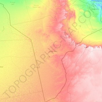
Name: Tataouine topographic map, elevation, terrain.
Location: Tataouine, Tunisia (30.22906 8.35683 33.23475 11.34198)
Average elevation: 295 m
Minimum elevation: -3 m
Maximum elevation: 714 m
Other topographic maps
Click on a map to view its topography, its elevation and its terrain.
Aïn Draham
Tunisia > Jendouba > عين دراهم الأحواز
The city is the capital of a delegation of 40,372 inhabitants. The city itself has an estimated population of 10,843 inhabitants (according to the census of 2004). It is located at an altitude of 800 meters on the slopes of the Djebel Bir (1014 m), one of the Kroumirie mountains. The city is located in one of…
Average elevation: 574 m
Carthage
The elevation of the land at the promontory on the seashore to the north-east (now called Sidi Bou Saïd), was twice as high above sea level as that at the Byrsa (100 m and 50 m). In between runs a ridge, several times reaching 50 m; it continues northwestward along the seashore, and forms the edge of a…
Average elevation: 9 m
Bizerte
Tunisia > Bizerte > بوبكر باكير
The bridge leads to the motorway A4 leading to Tunis–Carthage International Airport and the capital. On the town side the P11 passes semi-rural Louata, hugs Ichkeul Lake and branches into a western route, the P7, leading directly to Tabarka on the coast next to the Algerian border. The P11 leads south-west…
Average elevation: 28 m
Medina of Tunis
In the case of domestic architecture, the more a building is set back from the shops, the more it is valued. The concept of withdrawal and privacy is paramount. The late introduction of a sewer system means that much waste water still flows through the streets of the Medina. The largest houses and noble places…
Average elevation: 16 m
Ras Jebel
Tunisia > Bizerte > رأس الجبل الشمالية
Ras Jebel is set on a hill overlooking the Mediterranean Sea. It has an altitude of 53 meters (174 ft).
Average elevation: 62 m
Carthage
The elevation of the land at the promontory on the seashore to the north-east (now called Sidi Bou Saïd), was twice as high above sea level as that at the Byrsa (100 m and 50 m). In between runs a ridge, several times reaching 50 m; it continues northwestward along the seashore, and forms the edge of a…
Average elevation: 9 m
Aïn Draham
Tunisia > Jendouba > عين دراهم الأحواز
The city is the capital of a delegation of 40,372 inhabitants. The city itself has an estimated population of 10,843 inhabitants (according to the census of 2004). It is located at an altitude of 800 meters on the slopes of the Djebel Bir (1014 m), one of the Kroumirie mountains. The city is located in one of…
Average elevation: 574 m