
Pawlet topographic map
Interactive map
Click on the map to display elevation.
About this map
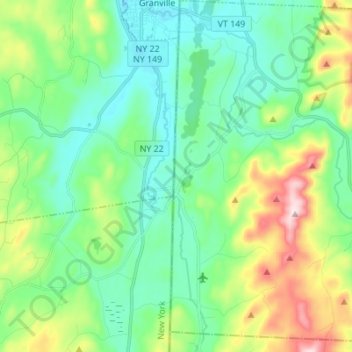
Name: Pawlet topographic map, elevation, terrain.
Location: Pawlet, Rutland County, Vermont, United States (43.30868 -73.25464 43.40860 -73.12083)
Average elevation: 232 m
Minimum elevation: 113 m
Maximum elevation: 553 m
Other topographic maps
Click on a map to view its topography, its elevation and its terrain.
North Pawlet Hills Natural Area
United States > Vermont > Rutland County > Wells
Average elevation: 332 m
Danby
United States > Vermont > Rutland County
Dorset Peak, part of the Taconic range, lies on the town's southern border and reaches an elevation of 3,804 feet (1,159 m). Danby quarry, located near the peak, opened in the early 20th century and is likely the world's largest underground marble quarry. It was reported in 2001 to have a total monthly output…
Average elevation: 499 m
Green Mountain National Forest
United States > Vermont > Rutland County > Mount Holly
Average elevation: 345 m
West Tinmouth
United States > Vermont > Rutland County > Tinmouth > West Tinmouth
Average elevation: 419 m