
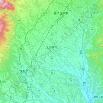
Ohtawara topographic map
Interactive map
Click on the map to display elevation.
About this map
Name: Ohtawara topographic map, elevation, terrain.
Location: Ohtawara, Tochigi Prefecture, Japan (36.76840 139.92167 36.94835 140.26739)
Average elevation: 276 m
Minimum elevation: 91 m
Maximum elevation: 1,265 m
Ōtawara is located in northeast Tochigi Prefecture in the foothills of the Nasu region. About 50% of Ōtawara is covered by rice fields with about 12% being mountains and forests. The average elevation of Ōtawara is 217.76 meters. Ōtawara is approximately 40 kilometers north of Utsunomiya, the capital of Tochigi, and approximately 50 km east of the historic city of Nikkō. The city is long in the east and west direction, and the eastern side of the city is bordered by Ibaraki and Fukushima prefectures. The Yamizo Mountains extend along the prefectural border with Ibaraki Prefecture in the eastern part of the prefecture. Rivers include the Naka River, which runs north–south in the eastern part of the city.
Other topographic maps
Click on a map to view its topography, its elevation and its terrain.
Maborikaigan 4-chome Park
Maborikaigan 4-chome Park, Maboricho 3-chome, Yokosuka, Kanagawa Prefecture, 238-8550, Japan
Average elevation: 22 m
Mount Fuji
Japan > Sunto County > Oyama
Mount Fuji, Oyama, Sunto County, Shizuoka Prefecture, Chubu Region, Japan
Average elevation: 3,261 m
Lake Sanaru
Lake Sanaru, Hamamatsu, Shizuoka Prefecture, Chubu Region, Japan
Average elevation: 16 m
Motoyama
Motoyama, Nagaoka County, Kochi Prefecture, 781-3601, Japan
Average elevation: 679 m
Setouchi
Setouchi, Oshima County, Kagoshima Prefecture, Japan
Average elevation: 26 m
Higashishirakawa
Higashishirakawa, Kamo County, Gifu Prefecture, Chubu Region, 509-1392, Japan
Average elevation: 658 m
Nishikigaoka-chuo Park
Nishikigaoka-chuo Park, Nishikigaoka 2-chome, Aoba Ward, Sendai, Miyagi Prefecture, Japan
Average elevation: 197 m
Katsura Imperial Villa
Katsura Imperial Villa, Road No. 142, Katsura-Kasugacho, Nishikyo Ward, Kyoto, Kyoto Prefecture, 615-8013, Japan
Average elevation: 25 m