
Wallonia topographic map
Interactive map
Click on the map to display elevation.
About this map
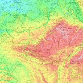
Name: Wallonia topographic map, elevation, terrain.
Location: Wallonia, Belgium (49.49698 2.84203 50.81212 6.40810)
Average elevation: 215 m
Minimum elevation: -2 m
Maximum elevation: 796 m
Wallonia is landlocked, with an area of 16,901 km2 (6,526 sq mi), or 55 percent of the total area of Belgium. The Sambre and Meuse valley, from Liège (70 m (230 ft)) to Charleroi (120 m (390 ft)) is an entrenched river in a fault line which separates Middle Belgium (elevation 100–200 m (330–660 ft)) and High Belgium (200–700 m (660–2,300 ft)). This fault line corresponds to a part of the southern coast of the late London-Brabant Massif. The valley, along with Haine and Vesdre valleys form the sillon industriel, the historical centre of the Belgian coalmining and steelmaking industry, and is also called the Walloon industrial backbone. Due to their long industrial historic record, several segments of the valley have received specific names: Borinage, around Mons, le Centre, around La Louvière, the Pays noir, around Charleroi and the Basse-Sambre, near Namur.
Other topographic maps
Click on a map to view its topography, its elevation and its terrain.
Hollogne-aux-Pierres
Belgium > Liège > Liège > Grâce-Hollogne
Hollogne-aux-Pierres, Grâce-Hollogne, Liège, Wallonia, 4460, Belgium
Average elevation: 162 m
Sint-Martens-Latem
Belgium > East Flanders > Gent
Sint-Martens-Latem, Gent, East Flanders, Flanders, Belgium
Average elevation: 8 m
Leuven
Belgium > Flemish Brabant > Leuven
Leuven, Flemish Brabant, Flanders, Belgium
Average elevation: 43 m
Ghent
Belgium > East Flanders > Gent
Ghent, Gent, East Flanders, Flanders, Belgium
Average elevation: 7 m
Battle of Waterloo
Belgium > Walloon Brabant > Waterloo
Battle of Waterloo, Route du Lion, Waterloo, Nivelles, Walloon Brabant, Wallonia, 1410, Belgium
Average elevation: 121 m
Voorde
Belgium > East Flanders > Aalst
Voorde, Ninove, Aalst, East Flanders, Belgium
Average elevation: 32 m
Ourodenberg
Belgium > Flemish Brabant > Leuven > Aarschot
Ourodenberg, Aarschot, Leuven, Flemish Brabant, 3200, Belgium
Average elevation: 16 m
Nessonvaux
Nessonvaux, Trooz, Liège, Wallonia, 4870, Belgium
Average elevation: 197 m
Wervik
Belgium > West Flanders > Ieper
Wervik, Ieper, West Flanders, Flanders, 8940, Belgium
Average elevation: 25 m
Imde
Belgium > Flemish Brabant > Halle-Vilvoorde > Wolvertem
Imde, Wolvertem, Meise, Halle-Vilvoorde, Flemish Brabant, Flanders, 1861, Belgium
Average elevation: 20 m
Rijkevorsel
Rijkevorsel, Turnhout, Antwerp, Flanders, 2310, Belgium
Average elevation: 24 m
Heurne
Belgium > East Flanders > Oudenaarde > Oudenaarde
Heurne, Oudenaarde, East Flanders, Flanders, Belgium
Average elevation: 17 m
Houthulst
Belgium > West Flanders > Diksmuide
Houthulst, Diksmuide, West Flanders, Flanders, 8650, Belgium
Average elevation: 18 m
Torhout
Belgium > West Flanders > Brugge
Torhout, Brugge, West Flanders, Flanders, 8820, Belgium
Average elevation: 22 m
Wemmel
Belgium > Flemish Brabant > Halle-Vilvoorde
Wemmel, Halle-Vilvoorde, Flemish Brabant, 1780, Belgium
Average elevation: 51 m
Boonwijk
Belgium > East Flanders > Dendermonde > Dendermonde > Sint-Gillis-bij-Dendermonde
Boonwijk, Sint-Gillis-bij-Dendermonde, Dendermonde, East Flanders, 9200, Belgium
Average elevation: 4 m
Den Dotter
Belgium > East Flanders > Aalst > Haaltert
Den Dotter, Gotegemstraat, Haaltert, Aalst, East Flanders, 9450, Belgium
Average elevation: 45 m
Schönberg
Belgium > Liège > Verviers > Saint Vith
Schönberg, Saint Vith, Verviers, Liège, Wallonia, 4780, Belgium
Average elevation: 493 m
Conrad
Belgium > Namur > Dinant > Vresse-sur-Semois
Conrad, Vresse-sur-Semois, Dinant, Namur, Wallonia, 5550, Belgium
Average elevation: 314 m
Heuvelland
Belgium > West Flanders > Ieper
Heuvelland, Ieper, West Flanders, Belgium
Average elevation: 35 m
Forchies-la-Marche
Belgium > Hainaut > Charleroi > Fontaine-l'Évêque
Forchies-la-Marche, Fontaine-l'Évêque, Charleroi, Hainaut, Wallonia, 6141, Belgium
Average elevation: 171 m
Sint-Lievens-Esse
Belgium > East Flanders > Aalst
Sint-Lievens-Esse, Herzele, Aalst, East Flanders, Flanders, Belgium
Average elevation: 61 m
Sombeke
Belgium > East Flanders > Dendermonde > Waasmunster
Sombeke, Waasmunster, Dendermonde, East Flanders, Flanders, 9250, Belgium
Average elevation: 15 m
Kaster
Belgium > West Flanders > Kortrijk > Anzegem
Kaster, Anzegem, Kortrijk, West Flanders, 8572, Belgium
Average elevation: 25 m
Meer
Belgium > Antwerp > Turnhout > Hoogstraten
Meer, Hoogstraten, Turnhout, Antwerp, Flanders, 2321, Belgium
Average elevation: 11 m
Anzegem
Belgium > West Flanders > Kortrijk
Anzegem, Kortrijk, West Flanders, Belgium
Average elevation: 32 m
Eeklo
Belgium > East Flanders > Eeklo > Eeklo
Eeklo, East Flanders, Flanders, 9900, Belgium
Average elevation: 5 m
Hollogne-sur-Geer
Hollogne-sur-Geer, Geer, Waremme, Liège, Wallonia, 4250, Belgium
Average elevation: 129 m
Sint-Pieters-Leeuw
Belgium > Flemish Brabant > Halle-Vilvoorde > Sint-Pieters-Leeuw
Sint-Pieters-Leeuw, Halle-Vilvoorde, Flemish Brabant, 1600, Belgium
Average elevation: 42 m
Winterslag
Winterslag, Genk, Hasselt, Limburg, 3600, Belgium
Average elevation: 71 m
Drongen
Belgium > East Flanders > Gent > Ghent
Drongen, Ghent, Gent, East Flanders, 9031, Belgium
Average elevation: 7 m
Marbehan
Belgium > Luxembourg > Virton
Marbehan, Rulles, Habay, Virton, Luxembourg, Wallonia, 6724, Belgium
Average elevation: 370 m
Vresse-sur-Semois
Vresse-sur-Semois, Dinant, Namur, Wallonia, 5550, Belgium
Average elevation: 328 m
Borgerhout
Belgium > Antwerp > Antwerp > Antwerp
Borgerhout, Antwerp, Flanders, 2140, Belgium
Average elevation: 8 m