
Nikko topographic map
Interactive map
Click on the map to display elevation.
About this map
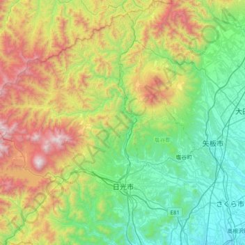
Name: Nikko topographic map, elevation, terrain.
Location: Nikko, Tochigi Prefecture, Japan (36.60097 139.32656 37.09190 139.85278)
Average elevation: 801 m
Minimum elevation: 125 m
Maximum elevation: 2,461 m
Nikkō (日光市, Nikkō-shi, IPA: [ɲikkoꜜːɕi]) is a city located in Tochigi Prefecture, Japan. As of 2 December 2020, the city had an estimated population of 80,239 in 36,531 households, and a population density of 55 persons per km2. The total area of the city is 1,449.83 square kilometres (559.78 sq mi). It is a popular destination for Japanese and international tourists. Attractions include the mausoleum of shōgun Tokugawa Ieyasu (Nikkō Tōshō-gū) and that of his grandson Iemitsu (Iemitsu-byō Taiyū-in), and the Futarasan Shrine, which dates to the year 767 AD. There are also many famous hot springs (onsen) in the area. Elevations range from 200 to 2,000 meters. The Japanese saying 【日光を見ずして結構と言うなかれ】 "Never say 'kekkō' until you've seen Nikkō"—kekkō meaning beautiful, magnificent or "I am satisfied"—is a reflection of the beauty and sites in Nikkō.
Other topographic maps
Click on a map to view its topography, its elevation and its terrain.
Maborikaigan 4-chome Park
Maborikaigan 4-chome Park, Maboricho 3-chome, Yokosuka, Kanagawa Prefecture, 238-8550, Japan
Average elevation: 22 m
Mount Fuji
Japan > Sunto County > Oyama
Mount Fuji, Oyama, Sunto County, Shizuoka Prefecture, Chubu Region, Japan
Average elevation: 3,261 m
Lake Sanaru
Lake Sanaru, Hamamatsu, Shizuoka Prefecture, Chubu Region, Japan
Average elevation: 16 m
Motoyama
Motoyama, Nagaoka County, Kochi Prefecture, 781-3601, Japan
Average elevation: 679 m
Setouchi
Setouchi, Oshima County, Kagoshima Prefecture, Japan
Average elevation: 26 m
Higashishirakawa
Higashishirakawa, Kamo County, Gifu Prefecture, Chubu Region, 509-1392, Japan
Average elevation: 658 m
Nishikigaoka-chuo Park
Nishikigaoka-chuo Park, Nishikigaoka 2-chome, Aoba Ward, Sendai, Miyagi Prefecture, Japan
Average elevation: 197 m