
Goa topographic map
Interactive map
Click on the map to display elevation.
About this map
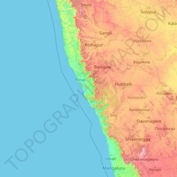
Name: Goa topographic map, elevation, terrain.
Location: Goa, India (12.70045 71.48551 17.90045 76.68551)
Average elevation: 291 m
Minimum elevation: -1 m
Maximum elevation: 1,831 m
Goa ocupa un área de 3.702 km². Gran parte de su costa está compuesta por una serie de riscos escarpados que se inician en la zona de los Ghats occidentales. El punto más alto es Sonsogor con una altitud de 1167 metros sobre el nivel del mar. En total, Goa tiene una línea costera de 101 km. Los principales ríos del estado son el Mandovi y el Zuari.
Other topographic maps
Click on a map to view its topography, its elevation and its terrain.
Shilla
India > Uttarakhand > Bhatwari
Shilla, Bhatwari, Uttarkashi District, Uttarakhand, India
Average elevation: 2,178 m
Kasani
India > Maharastra > Patan
Kasani, Patan, Satara District, Maharastra, India
Average elevation: 791 m
Leh
India > Ladaj > Leh Tehsil
Leh, Leh Tehsil, Distrito de Leh, Ladaj, India
Average elevation: 3,653 m
Bangalore
India > Karnataka > Bangalore North
Bangalore, Bangalore North, Bengaluru Urban, Karnataka, 560001, India
Average elevation: 879 m
Salkha
India > Rajastán > Jaisalmer Tehsil
Salkha, Jaisalmer Tehsil, Jaisalmer District, Rajastán, India
Average elevation: 205 m
Shaura
India > Madhya Pradesh > Mau Tahsil
Shaura, Mau Tahsil, Bhind District, Madhya Pradesh, India
Average elevation: 174 m
Tuman
India > Madhya Pradesh > Dhimarkheda Tahsil
Tuman, Dhimarkheda Tahsil, Katni District, Madhya Pradesh, India
Average elevation: 444 m
Charala
India > Andhra Pradesh > Chowdepalle
Charala, Chowdepalle, Chittoor District, Andhra Pradesh, India
Average elevation: 719 m
Diwanganj
India > Madhya Pradesh > Raisen Tahsil
Diwanganj, Raisen Tahsil, Raisen District, Madhya Pradesh, India
Average elevation: 470 m
Rudrapur
India > Uttarakhand > Kichha
Rudrapur, Kichha, Udham Singh Nagar District, Uttarakhand, 263153, India
Average elevation: 217 m
Rudrapur
India > Maharastra > Sawali
Rudrapur, Sawali, Distrito de Chandrapur, Maharastra, India
Average elevation: 190 m
Badrinath
India > Uttarakhand > Joshimath Tehsil
Badrinath, Joshimath Tehsil, Chamoli district, Uttarakhand, India
Average elevation: 4,052 m
Jaynagar Majilpur
India > Bengala Occidental > Jaynagar - I
Jaynagar Majilpur, Jaynagar - I, South 24 Parganas, Bengala Occidental, 743337, India
Average elevation: 5 m
Muhammad Pira
India > Panyab > Fazilka Tahsil
Muhammad Pira, Fazilka Tahsil, Distrito de Fazlika, Panyab, India
Average elevation: 177 m
Pachara
India > Maharastra > Tumsar Taluka
Pachara, Tumsar Taluka, Bhandara, Maharastra, India
Average elevation: 286 m
Sayan
India > Guyarat > Olpad Taluka
Sayan, Olpad Taluka, Surat, Guyarat, 394130, India
Average elevation: 18 m
Simbal
India > Himachal Pradesh > Kumharsain > Simbal
Simbal, Kumharsain, Shimla, Himachal Pradesh, 171213, India
Average elevation: 2,275 m
Poonch
India > Jammu y Cachemira > Haveli > Poonch
Poonch, Haveli, Poonch district, Jammu y Cachemira, 185101, India
Average elevation: 1,529 m
Narakoduru
India > Andhra Pradesh > Chebrolu
Narakoduru, Chebrolu, Guntur District, Andhra Pradesh, 522212, India
Average elevation: 18 m
Bankheri
India > Madhya Pradesh > Bankheri
Bankheri, Bankhedi Tahsil], Hoshangabad, Madhya Pradesh, 461990, India
Average elevation: 354 m
Jack Fruit
India > Maharastra > Thane
Jack Fruit, Hariom Nagar Road, Neelam Nagar, T Ward, Zone 6, Thane, Mumbai Suburban, Maharastra, 400081, India
Average elevation: 7 m
Dadra y Nagar Haveli
India > Dadra and Nagar Haveli and Daman and Diu
Dadra y Nagar Haveli, Dadra and Nagar Haveli and Daman and Diu, India
Average elevation: 88 m
Puducherry
India > Puducherry > Puducherry
Puducherry, Puducherry Taluk, Puducherry district, Puducherry, 605001, India
Average elevation: 10 m
Lakshminagar
India > Kerala > Lakshminagar
Lakshminagar, Kasaragod district, Kerala, 671314, India
Average elevation: 16 m
Srinivasa Nagar
India > Tamil Nadu > Chennai
Srinivasa Nagar, Zone 15 Sholinganallur, Chennai, Chennai district, Tamil Nadu, 600096, India
Average elevation: 5 m
Rangpuri
India > Delhi > Nueva Delhi > Rangpuri
Rangpuri, Nueva Delhi, Delhi, 110037, India
Average elevation: 244 m
Ibrahimpura
India > Karnataka > Ibrahimpura
Ibrahimpura, Siruguppa taluku, Bellary district, Karnataka, 583121, India
Average elevation: 363 m
Eluru
India > Andhra Pradesh > Eluru
Eluru, West Godavari, Andhra Pradesh, 534001, India
Average elevation: 22 m
Nakashipara
Nakashipara, Nadia, Bengala Occidental, India
Average elevation: 14 m
Mira-Bhayander
India > Maharastra > Mira-Bhayander
Mira-Bhayander, Thane, Maharastra, 401101, India
Average elevation: 40 m