
Romford topographic map
Interactive map
Click on the map to display elevation.
About this map
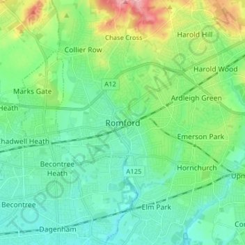
Name: Romford topographic map, elevation, terrain.
Location: Romford, Greater London, England, RM1 1RX, United Kingdom (51.53605 0.14226 51.61605 0.22226)
Average elevation: 29 m
Minimum elevation: 1 m
Maximum elevation: 109 m
The town centre is about 50 feet (15 m) above sea level on a gravel terrace rising from the River Thames. The north of the town has developed on London Clay and is situated as much as 150 ft (46 m) above sea level. A continuous gentle rise in the eastern suburbs towards Gidea Park and Harold Wood peaks around 177 feet (54 m) around the Harold Court. On the northern side, Harold Hill peaks at 75 m (246 ft). The semi-rural area north of Collier Row and Harold Hill consists of many rolls of hills, with elevation peaking at the village of Havering-atte-Bower, 344 feet (105 m). The town centre is for the most part contained within a ring road formed of St Edwards Way, Mercury Gardens, Thurloe Gardens, Oldchurch Road and Waterloo Road. The market place and much of South Street and the High Street are pedestrianised. The railway cuts through the town from east to west on a viaduct, with the bulk of the central Romford area to its north. The River Rom flows through the town in underground channels and joins the Thames after flowing through Hornchurch; elsewhere along its course it is known as the River Beam and forms part of the strategic waterways Blue Ribbon Network. Romford has formed part of the continuously built-up area of London since the 1930s and is contiguous with Rush Green to the west, Collier Row to the north, Gidea Park to the east and Hornchurch to the south east.
Other topographic maps
Click on a map to view its topography, its elevation and its terrain.
London
United Kingdom > England > London
London, Greater London, England, SW1A 2DX, United Kingdom
Average elevation: 42 m
London
London, Greater London, England, United Kingdom
Average elevation: 66 m
Bristol
United Kingdom > England > City of Bristol
Bristol, City of Bristol, West of England, England, United Kingdom
Average elevation: 55 m
East of England
East of England, England, United Kingdom
Average elevation: 39 m
Dorset
United Kingdom > England > Talbot Village
Dorset, Alder Road, Branksome, Talbot Village, Bournemouth, Christchurch and Poole, South West England, England, BH12 5BJ, United Kingdom
Average elevation: 57 m
Brighton
United Kingdom > England > Brighton and Hove
Brighton, Brighton and Hove, England, United Kingdom
Average elevation: 64 m
Northamptonshire
Northamptonshire, England, United Kingdom
Average elevation: 97 m
Lincolnshire
Lincolnshire, East Midlands, England, United Kingdom
Average elevation: 28 m
Andover
United Kingdom > England > Hampshire > Test Valley
Andover, Test Valley, Hampshire, England, United Kingdom
Average elevation: 90 m
Swindon
United Kingdom > England > Swindon
Swindon, England, SN1 1LF, United Kingdom
Average elevation: 108 m
Holme Fen
United Kingdom > England > Cambridgeshire > East Cambridgeshire > Haddenham
Holme Fen, Haddenham, Aldreth, East Cambridgeshire, Cambridgeshire, Cambridgeshire and Peterborough, England, CB6 3PN, United Kingdom
Average elevation: 4 m
Greater Manchester
Greater Manchester, England, United Kingdom
Average elevation: 141 m
Oxford
United Kingdom > England > Oxfordshire
Oxford, Oxfordshire, England, United Kingdom
Average elevation: 81 m
Chesterfield
United Kingdom > England > Derbyshire
Chesterfield, Derbyshire, England, United Kingdom
Average elevation: 127 m
Sheffield
Sheffield, South Yorkshire, England, United Kingdom
Average elevation: 168 m
Nottingham
United Kingdom > England > Nottinghamshire
Nottingham, England, United Kingdom
Average elevation: 56 m
East Suffolk
United Kingdom > England > Suffolk
East Suffolk, Suffolk, England, United Kingdom
Average elevation: 22 m
South East England
South East England, England, United Kingdom
Average elevation: 69 m
Lancashire
Lancashire, North West England, England, United Kingdom
Average elevation: 153 m
Saffron Walden
United Kingdom > England > Essex > Uttlesford
Saffron Walden, Uttlesford, Essex, England, CB10 1NQ, United Kingdom
Average elevation: 88 m
Basingstoke
United Kingdom > England > Hampshire > Basingstoke and Deane
Basingstoke, Basingstoke and Deane, Hampshire, England, United Kingdom
Average elevation: 110 m
Birmingham
Birmingham, West Midlands Combined Authority, England, United Kingdom
Average elevation: 138 m
Leeds
United Kingdom > England > Leeds
Leeds, Yorkshire and the Humber, England, LS1 6AL, United Kingdom
Average elevation: 94 m
North York Moors National Park
United Kingdom > England > North Yorkshire
North York Moors National Park, North Yorkshire, Tees Valley, England, United Kingdom
Average elevation: 110 m
Cheltenham
United Kingdom > England > Gloucestershire
Cheltenham, Gloucestershire, England, United Kingdom
Average elevation: 109 m
Bath
United Kingdom > England > Bath and North East Somerset
Bath, Bath and North East Somerset, West of England, England, United Kingdom
Average elevation: 100 m
Winchester
United Kingdom > England > Hampshire
Winchester, Hampshire, England, United Kingdom
Average elevation: 73 m
Corby
United Kingdom > England > North Northamptonshire > Corby
Corby, North Northamptonshire, East Midlands, England, United Kingdom
Average elevation: 98 m
Ipswich
United Kingdom > England > Suffolk
Ipswich, Suffolk, England, United Kingdom
Average elevation: 29 m
Norwich
United Kingdom > England > Norfolk
Norwich, Norfolk, England, United Kingdom
Average elevation: 28 m
Cambridge
United Kingdom > England > Cambridge
Cambridge, Cambridgeshire, East of England, England, United Kingdom
Average elevation: 18 m
Liverpool
Liverpool, Liverpool City Region, England, United Kingdom
Average elevation: 26 m
Patrick Brompton
United Kingdom > England > North Yorkshire
Patrick Brompton, North Yorkshire, England, United Kingdom
Average elevation: 72 m
Shropshire
Shropshire, West Midlands, England, United Kingdom
Average elevation: 166 m
Lake District National Park
Lake District National Park, England, United Kingdom
Average elevation: 206 m
Chiltern District
United Kingdom > England > Buckinghamshire > Chalfont St Peter
Chiltern District, Chalfont St Peter, Buckinghamshire, England, United Kingdom
Average elevation: 137 m
Wimbledon
Wimbledon, Greater London, England, SW19 7NL, United Kingdom
Average elevation: 26 m