
Make a donation
Gear up for your next adventure:
As an Amazon Associate, this site earns from qualifying purchases at no extra cost to you.
Northern Ireland topographic map
Click on the map to display elevation.
Make a donation
Gear up for your next adventure:
As an Amazon Associate, this site earns from qualifying purchases at no extra cost to you.
About this map
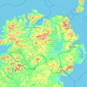
Name: Northern Ireland topographic map, elevation, terrain.
Location: Northern Ireland, United Kingdom (53.87017 -8.17751 55.44358 -5.07778)
Average elevation: 79 m
Minimum elevation: -4 m
Maximum elevation: 791 m
United Kingdom trails, hiking, mountain biking, running and outdoor activities
Make a donation
Gear up for your next adventure:
As an Amazon Associate, this site earns from qualifying purchases at no extra cost to you.
Other topographic maps
Click on a map to view its topography, its elevation and its terrain.
United Kingdom
Scotland accounts for just under a third (32 per cent) of the total area of the UK, covering 78,772 square kilometres (30,410 sq mi). This includes nearly eight hundred islands, predominantly west and north of the mainland; notably the Hebrides, Orkney Islands and Shetland Islands. Scotland is the most…
Average elevation: 79 m
Edinburgh
United Kingdom > Scotland > Edinburgh
Some have called Edinburgh the Athens of the North for a variety of reasons. The earliest comparison between the two cities showed that they had a similar topography, with the Castle Rock of Edinburgh performing a similar role to the Athenian Acropolis. Both of them had flatter, fertile agricultural land…
Average elevation: 104 m
Glasgow
United Kingdom > Scotland > Glasgow City
Glasgow itself was reputed to have been founded by the Christian missionary Saint Mungo in the 6th century. He established a church on the Molendinar Burn, where the present Glasgow Cathedral stands, and in the following years Glasgow became a religious centre. Glasgow grew over the following centuries. The…
Average elevation: 128 m
Make a donation
Gear up for your next adventure:
As an Amazon Associate, this site earns from qualifying purchases at no extra cost to you.
Cambridge
United Kingdom > England > Cambridge
The city, like most of the UK, has a maritime climate highly influenced by the Gulf Stream. Located in the driest region of Britain, Cambridge's rainfall averages around 570 mm (22.44 in) per year, around half the national average, with some years occasionally falling into the semi-arid (under 500 mm (19.69…
Average elevation: 18 m
Bedford
United Kingdom > England > Bedford
As with the rest of the United Kingdom, Bedford has a maritime climate, with a limited range of temperatures, and generally even rainfall throughout the year. The nearest Met Office weather station to Bedford is Bedford (Thurleigh) airport, about 6.5 miles (10.5 km) north of Bedford town centre at an elevation…
Average elevation: 37 m
Salisbury
United Kingdom > England > Salisbury
Bishop of Salisbury Hubert Walter was instrumental in the negotiations with Saladin during the Third Crusade, but he spent little time in his diocese prior to his elevation to archbishop of Canterbury. The brothers Herbert and Richard Poore succeeded him and began planning the relocation of the cathedral into…
Average elevation: 96 m
Make a donation
Gear up for your next adventure:
As an Amazon Associate, this site earns from qualifying purchases at no extra cost to you.
Wallasey
Wallasey is situated at the north-east of the Wirral Peninsula, on the western side of the River Mersey and adjoining the Irish Sea. The area is approximately 9.5 km (5.9 mi) east-north-east of the Dee Estuary at Hoylake. Wallasey is at an elevation of between 0–50 m (0–164 ft) above sea level, with the…
Average elevation: 12 m
West Bromwich
United Kingdom > England > Sandwell
The town's football club is West Bromwich Albion. The club was founded in 1878 and in 1888 it became one of the 12 founder members of the Football League. It won the league championship in 1920 and has won the FA Cup five times, most recently in 1968, and won the League Cup in 1966. Albion were based in and…
Average elevation: 149 m
Make a donation
Gear up for your next adventure:
As an Amazon Associate, this site earns from qualifying purchases at no extra cost to you.
Leeds
Lying in the eastern foothills of the Pennines, there is a significant variation in elevation within the city's built-up area. The district ranges from 1,115 feet (340 m) in the far west on the slopes of Ilkley Moor to about 33 feet (10 m) where the rivers Aire and Wharfe cross the eastern boundary. Land rises…
Average elevation: 94 m
Make a donation
Gear up for your next adventure:
As an Amazon Associate, this site earns from qualifying purchases at no extra cost to you.
Hull
United Kingdom > England > Kingston upon Hull
Kingston upon Hull is on the northern bank of the Humber Estuary. The city centre is west of the River Hull and close to the Humber. The city is built upon alluvial and glacial deposits which overlie chalk rocks but the underlying chalk has no influence on the topography. The land within the city is generally…
Average elevation: 21 m
Reading
United Kingdom > England > Reading
Mary Russell Mitford lived in Reading for a number of years and then spent the rest of her life just outside the town at Three Mile Cross and Swallowfield. The fictional Belford Regis of her eponymous novel, first published in 1835, is largely based on Reading. Described with topographical accuracy, it is…
Average elevation: 56 m
Baggeridge Country Park
United Kingdom > England > Staffordshire > South Staffordshire
Average elevation: 146 m
Make a donation
Gear up for your next adventure:
As an Amazon Associate, this site earns from qualifying purchases at no extra cost to you.
Make a donation
Gear up for your next adventure:
As an Amazon Associate, this site earns from qualifying purchases at no extra cost to you.
Snowdon
United Kingdom > Wales > Gwynedd
Snowdon (/ˈsnoʊdən/) or Yr Wyddfa (pronounced [ər ˈʊɨ̞̯ðva] (listen)), is the highest mountain in Wales, at an elevation of 1,085 metres (3,560 ft) above sea level, and the highest point in the British Isles outside the Scottish Highlands. It is located in Snowdonia National Park (Parc Cenedlaethol…
Average elevation: 692 m
Lickey Hills Country Park
United Kingdom > England > Worcestershire > Bromsgrove > Cofton Hackett CP
Average elevation: 209 m
Make a donation
Gear up for your next adventure:
As an Amazon Associate, this site earns from qualifying purchases at no extra cost to you.
Stow-on-the-Wold
United Kingdom > England > Gloucestershire > Cotswold District
Average elevation: 163 m
Make a donation
Gear up for your next adventure:
As an Amazon Associate, this site earns from qualifying purchases at no extra cost to you.
Aberystwyth
United Kingdom > Wales > Ceredigion
Aberystwyth experiences an oceanic climate (Köppen climate classification Cfb) similar to almost all of the United Kingdom. This is particularly pronounced due to its west coast location facing the Irish Sea. Air undergoes little land moderation and so temperatures closely reflect the sea temperature when…
Average elevation: 39 m
Ely
United Kingdom > England > Ely
For over 800 years the cathedral and its associated buildings—built on an elevation 68 feet (21 m) above the nearby fens—have visually influenced the city and its surrounding area. Geographer John Jones, writing in 1924, reports that "from the roof of King's Chapel in Cambridge, on a clear day, Ely can be…
Average elevation: 13 m
Make a donation
Gear up for your next adventure:
As an Amazon Associate, this site earns from qualifying purchases at no extra cost to you.
Plymouth
United Kingdom > England > Devon > Plymouth
The River Plym, which flows off Dartmoor to the north-east, forms a smaller estuary to the east of the city called Cattewater. Plymouth Sound is protected from the sea by the Plymouth Breakwater, in use since 1814. In the Sound is Drake's Island which is seen from Plymouth Hoe, a flat public area on top of…
Average elevation: 81 m
Aberdeen
United Kingdom > Scotland > Aberdeen
Two weather stations collect climate data for the area, Aberdeen/Dyce Airport, and Craibstone. Both are about 4 1⁄2 miles (7 km) to the north west of the city centre, and given that they are in close proximity to each other, exhibit very similar climatic regimes. Dyce tends to have marginally warmer daytime…
Average elevation: 52 m
Make a donation
Gear up for your next adventure:
As an Amazon Associate, this site earns from qualifying purchases at no extra cost to you.
Make a donation
Gear up for your next adventure:
As an Amazon Associate, this site earns from qualifying purchases at no extra cost to you.
Letchworth
United Kingdom > England > Hertfordshire > North Hertfordshire > Letchworth
Average elevation: 80 m
Portsmouth
United Kingdom > England > Hampshire > Portsmouth
By road, Portsmouth lies 73.5 miles (118.3 km) from Central London, 49.5 miles (79.7 km) west of Brighton, and 22.3 miles (35.9 km) east of Southampton. Portsmouth is situated primarily on Portsea Island and is the United Kingdom's only island city, although parts of it have expanded onto the mainland. Gosport…
Average elevation: 28 m
Make a donation
Gear up for your next adventure:
As an Amazon Associate, this site earns from qualifying purchases at no extra cost to you.
Make a donation
Gear up for your next adventure:
As an Amazon Associate, this site earns from qualifying purchases at no extra cost to you.
Littleborough
In the late 18th century, the low-altitude Summit Gap between Littleborough and Walsden was approved as the best route over the Pennines for the Rochdale Canal and the Manchester to Leeds railway; Hollingworth Lake was built at Littleborough's south side as a feeder reservoir to regulate the waters of the…
Average elevation: 266 m
Make a donation
Gear up for your next adventure:
As an Amazon Associate, this site earns from qualifying purchases at no extra cost to you.
Make a donation
Gear up for your next adventure:
As an Amazon Associate, this site earns from qualifying purchases at no extra cost to you.
Make a donation
Gear up for your next adventure:
As an Amazon Associate, this site earns from qualifying purchases at no extra cost to you.
Make a donation
Gear up for your next adventure:
As an Amazon Associate, this site earns from qualifying purchases at no extra cost to you.
Make a donation
Gear up for your next adventure:
As an Amazon Associate, this site earns from qualifying purchases at no extra cost to you.
Make a donation
Gear up for your next adventure:
As an Amazon Associate, this site earns from qualifying purchases at no extra cost to you.
Make a donation
Gear up for your next adventure:
As an Amazon Associate, this site earns from qualifying purchases at no extra cost to you.
Make a donation
Gear up for your next adventure:
As an Amazon Associate, this site earns from qualifying purchases at no extra cost to you.
Gateshead
United Kingdom > England > Tyne and Wear > Gateshead
One of the most distinguishing features of Gateshead is its topography. The land rises 230 feet (70 m) from Gateshead Quays to the town centre and continues rising to a height of 525 feet (160 m) at Queen Elizabeth Hospital in Sheriff Hill. This is in contrast to the flat and low lying Team Valley located on…
Average elevation: 62 m
Make a donation
Gear up for your next adventure:
As an Amazon Associate, this site earns from qualifying purchases at no extra cost to you.
Cambridge
United Kingdom > England > Cambridgeshire
The city, like most of the UK, has a maritime climate highly influenced by the Gulf Stream. Located in the driest region of Britain, Cambridge's rainfall averages around 570 mm (22.44 in) per year, around half the national average, The driest recent year was in 2011 with 380.4 mm (14.98 in) of rain at the…
Average elevation: 33 m
Make a donation
Gear up for your next adventure:
As an Amazon Associate, this site earns from qualifying purchases at no extra cost to you.
Make a donation
Gear up for your next adventure:
As an Amazon Associate, this site earns from qualifying purchases at no extra cost to you.
Make a donation
Gear up for your next adventure:
As an Amazon Associate, this site earns from qualifying purchases at no extra cost to you.