
Pike County topographic map
Interactive map
Click on the map to display elevation.
About this map
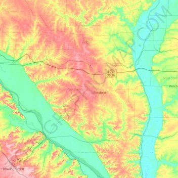
Name: Pike County topographic map, elevation, terrain.
Location: Pike County, Illinois, United States (39.39519 -91.37001 39.84417 -90.56735)
Average elevation: 184 m
Minimum elevation: 127 m
Maximum elevation: 283 m
Other topographic maps
Click on a map to view its topography, its elevation and its terrain.
Elmhurst
United States > Illinois > DuPage County
Due to local topography, the town has had a tendency to flood in the past after large rainfalls; the city is currently undertaking a large effort to mitigate future flooding.
Average elevation: 207 m
Riley
United States > Illinois > McHenry County
Riley, elevation 807 feet (246 m), is an unincorporated community and census-designated place in McHenry County, Illinois, United States. It was named a CDP before the 2020 census, at which time it had a population of 10.
Average elevation: 250 m
Hinsdale
United States > Illinois > Hinsdale
Hinsdale is a village in Cook and DuPage counties in the U.S. state of Illinois. Hinsdale is a western suburb of Chicago. The population was 16,816 at the 2010 census, most of whom lived in DuPage County. The town's ZIP code is 60521, which is listed in the top 1% of wealthiest towns in Illinois as well as the…
Average elevation: 214 m
Pyramid State Recreation Area
United States > Illinois > Perry County > Denmark
Average elevation: 131 m
Lake Naomi
United States > Illinois > Lake County > Hawthorn Woods > White Birch Lakes
Average elevation: 261 m
Chicago, North Shore & Milwaukee
United States > Illinois > Cook County > Northbrook > Williamsburg Square
Average elevation: 198 m
East Meadows
United States > Illinois > Effingham County > Altamont > East Meadows
Average elevation: 188 m
West Branch Du Page River
United States > Illinois > Cook County > Schaumburg
Average elevation: 249 m
Elmwood Park
United States > Illinois > Cook County > Elmwood Park > Elmwood Park
Average elevation: 194 m