
Ninh Thuan province topographic map
Interactive map
Click on the map to display elevation.
About this map
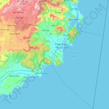
Name: Ninh Thuan province topographic map, elevation, terrain.
Location: Ninh Thuan province, Vietnam (10.76308 108.55166 12.16453 109.53737)
Average elevation: 282 m
Minimum elevation: -2 m
Maximum elevation: 2,229 m
Ninh Thuận's topography is typical for the South Central Coast in that high mountains are located not only near the western border to the Central Highlands, but also near the coast, the highest of which is Chúa mountain (Vietnamese: Núi Chúa) at 1,040 metres (3,410 ft) in the north east of the province. Several other peaks with heights up to 643 metres (2,110 ft), including Đá Bạc mountain (Vietnamese: Núi Đá Bạc) in the south, are located along the coast. The highest mountains are located at the borders to Khánh Hòa province and Lâm Đồng province, with three mountains of over 1,600 metres (5,200 ft) and the highest at 1,652 metres (5,420 ft), Sương Mù mountain (Vietnamese: Núi Sương Mù). Only a small part of the province around Phan Rang has elevations of under 50 metres (160 ft). The province's major river is the Dinh River, which flows through the main lowland of the province as well as Phan Rang. It has several tributaries in the province and is connected to Don Duong Lake in Lâm Đồng province.
Other topographic maps
Click on a map to view its topography, its elevation and its terrain.
Chanh My Ward
Vietnam > Binh Duong province > Thủ Dầu Một
Chanh My Ward, Thủ Dầu Một, Bình Dương Province, Vietnam
Average elevation: 9 m
Phú Giáo District
Phú Giáo District, Bình Dương Province, Vietnam
Average elevation: 55 m
Xã Tân Hòa
Vietnam > Tra Vinh province > Tiểu Cần District
Xã Tân Hòa, Tiểu Cần District, Trà Vinh Province, Vietnam
Average elevation: 3 m
Gia Ninh
Vietnam > Quang Binh province > Quảng Ninh District
Gia Ninh, Quảng Ninh District, Quảng Bình Province, Vietnam
Average elevation: 9 m
Mường Ảng District
Mường Ảng District, Điện Biên Province, Vietnam
Average elevation: 930 m
Dalat
Vietnam > Lâm Đồng Province > Dalat
Dalat, Đà Lạt District, Lâm Đồng Province, 6700, Vietnam
Average elevation: 1,360 m
Scenic Viewpoint
Vietnam > Ninh Binh province > Hoa Lư District > Tam Cốc
Scenic Viewpoint, Thai Vi, Tam Cốc, Hoa Lư District, Ninh Bình Province, 08213, Vietnam
Average elevation: 27 m
Công viên Tao Đàn
Vietnam > Kien Giang Province > Hà Tiên
Công viên Tao Đàn, Khu phố 5, Phường Bình San, Hà Tiên, Kiên Giang Province, Vietnam
Average elevation: 6 m
Núi Pha Luông
Vietnam > Son La province > Mộc Châu District
Núi Pha Luông, Mộc Châu District, Sơn La Province, Vietnam
Average elevation: 1,399 m
Xã Bình Khánh
Xã Bình Khánh, Can Gio District, Ho Chi Minh City, Vietnam
Average elevation: 2 m
Xã Bình Khánh
Vietnam > Bến Tre Province > Mỏ Cày Nam District
Xã Bình Khánh, Mỏ Cày Nam District, Bến Tre Province, Vietnam
Average elevation: 3 m
Long Hoa Commune
Long Hoa Commune, Can Gio District, Ho Chi Minh City, Vietnam
Average elevation: 1 m
Detian Falls
Vietnam > Cao Bang province > Trùng Khánh District
Detian Falls, Trùng Khánh District, Cao Bằng Province, Vietnam
Average elevation: 483 m
Xã Phước Thiền
Vietnam > Dong Nai province > Nhơn Trạch District
Xã Phước Thiền, Nhơn Trạch District, Đồng Nai Province, Vietnam
Average elevation: 11 m
Nhơn Trạch District
Nhơn Trạch District, Đồng Nai Province, Vietnam
Average elevation: 6 m
Xã Hòa Ninh
Xã Hòa Ninh, Hòa Vang District, Đà Nẵng, Vietnam
Average elevation: 108 m
Công viên Bùi Thị Xuân
Vietnam > Thừa Thiên Huế Province > Huế
Công viên Bùi Thị Xuân, Phường Phường Đúc, Huế, Thừa Thiên Huế Province, Vietnam
Average elevation: 9 m
Ban Co Peak
Ban Co Peak, Đường Lê Văn Lương, Phường Thọ Quang, Sơn Trà District, Đà Nẵng, 50207, Vietnam
Average elevation: 308 m
Hà Rai
Vietnam > Phu Yen province > Đồng Xuân District
Hà Rai, Đồng Xuân District, Phú Yên Province, Vietnam
Average elevation: 73 m
Vũng Tàu
Vietnam > Bà Rịa - Vũng Tàu Province
Vũng Tàu, Bà Rịa - Vũng Tàu Province, Vietnam
Average elevation: 3 m
Landing Zone X-Ray
Vietnam > Gia Lai Province > Chư Prông District
Landing Zone X-Ray, Quốc lộ 14C, Chư Prông District, Gia Lai Province, Vietnam
Average elevation: 229 m
Yên Thủy District
Yên Thủy District, Hoà Bình province, Vietnam
Average elevation: 125 m
Phường 10
Vietnam > Lâm Đồng Province > Da Lat City
Phường 10, Da Lat City, Lâm Đồng Province, Vietnam
Average elevation: 1,399 m
Dong Hoa
Vietnam > Binh Duong province > Di An City > Di An
Dong Hoa, Dĩ An, Di An City, Bình Dương Province, Vietnam
Average elevation: 25 m
Quang Bình District
Quang Bình District, Hà Giang Province, Vietnam
Average elevation: 409 m
Thành phố Tân Uyên
Thành phố Tân Uyên, Bình Dương Province, 75409, Vietnam
Average elevation: 30 m
Tây Ninh City
Tây Ninh City, Tây Ninh Province, Vietnam
Average elevation: 28 m
Hương Khê District
Hương Khê District, Hà Tĩnh Province, 46003, Vietnam
Average elevation: 262 m
Hoc Mon District
Hoc Mon District, Ho Chi Minh City, Vietnam
Average elevation: 5 m
Ngọc Lặc District
Ngọc Lặc District, Thanh Hoá Province, Vietnam
Average elevation: 104 m
Đầm Thị Nại
Vietnam > Bình Định Province > Tuy Phước District > Hải Minh
Đầm Thị Nại, Hải Minh, Tuy Phước District, Bình Định Province, Vietnam
Average elevation: 20 m
Phường Xuân Bình
Vietnam > Dong Nai province > Long Khánh City
Phường Xuân Bình, Long Khánh City, Đồng Nai Province, Vietnam
Average elevation: 177 m
Phường Quan Hoa
Phường Quan Hoa, Cau Giay District, Hà Nội, Vietnam
Average elevation: 12 m
M'Đrắk
Vietnam > Đắk Lắk province > M'Đrăk District
M'Đrắk, M'Đrăk District, Đăk Lăk Province, Vietnam
Average elevation: 451 m
Ben Cau
Vietnam > Tay Ninh province > Ben Cau District
Ben Cau, Ben Cau District, Tây Ninh Province, Vietnam
Average elevation: 7 m
A Lưới District
Vietnam > Thừa Thiên Huế Province
A Lưới District, Thừa Thiên Huế Province, Vietnam
Average elevation: 581 m
Núi Nứa
Vietnam > Bà Rịa - Vũng Tàu Province > Chau Duc District > Xuan Son Commune
Núi Nứa, Xuan Son Commune, Chau Duc District, Bà Rịa - Vũng Tàu Province, Vietnam
Average elevation: 78 m
Ham Rong Ward
Vietnam > Lao Cai province > Sa Pa
Ham Rong Ward, Sa Pa, Lào Cai Province, Vietnam
Average elevation: 1,439 m