
Pushmataha County topographic map
Interactive map
Click on the map to display elevation.
About this map
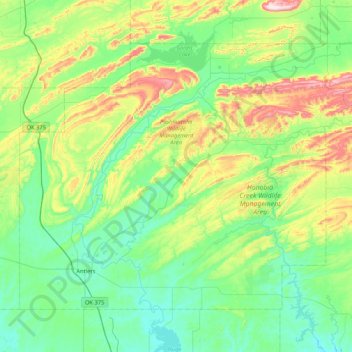
Name: Pushmataha County topographic map, elevation, terrain.
Location: Pushmataha County, Oklahoma, United States (34.15664 -95.77937 34.68128 -94.93760)
Average elevation: 240 m
Minimum elevation: 117 m
Maximum elevation: 643 m
Other topographic maps
Click on a map to view its topography, its elevation and its terrain.
Sutton Urban Wilderness Park
United States > Oklahoma > Cleveland County > Norman
Average elevation: 365 m
Medicine Bluffs
United States > Oklahoma > Comanche County > Lawton > White Wolf Bridge
Average elevation: 363 m
Southwest Oklahoma City Sludge Lagoon Dam
United States > Oklahoma > Cleveland County > Oklahoma City
Average elevation: 348 m
Newalla
United States > Oklahoma > Oklahoma County > Oklahoma City
Newalla, with a current elevation of 1,148 feet, is located within the Eastern bounds of Oklahoma County and appears on the Harrah, Oklahoma U.S. Geological Survey Map due to their proximity. Newalla is a geographic area which spans unincorporated Oklahoma County and unincorporated Cleveland County (also…
Average elevation: 343 m
No Head Hollow Public Use Area
United States > Oklahoma > Cherokee County > Tahlequah
Average elevation: 267 m
Honey Springs Battlefield
United States > Oklahoma > McIntosh County > Rentiesville
Average elevation: 185 m
Lightning Creek Holding Pond B Dam
United States > Oklahoma > Oklahoma County > Oklahoma City
Average elevation: 386 m