
Yellowstone National Park topographic map
Interactive map
Click on the map to display elevation.
Yellowstone National Park
Yellowstone National Park spans an area of 3,468.4 sq mi (8,983 km2), comprising lakes, canyons, rivers, and mountain ranges. Yellowstone Lake is one of the largest high-elevation lakes in North America and is centered over the Yellowstone Caldera, the largest supervolcano on the continent. The caldera is considered a dormant volcano. It has erupted with tremendous force several times in the last two million years. Well over half of the world's geysers and hydrothermal features are in Yellowstone, fueled by this ongoing volcanism. Lava flows and rocks from volcanic eruptions cover most of the land area of Yellowstone. The park is the centerpiece of the Greater Yellowstone Ecosystem, the largest remaining nearly-intact ecosystem in the Earth's northern temperate zone. In 1978, Yellowstone was named a UNESCO World Heritage Site.
About this map
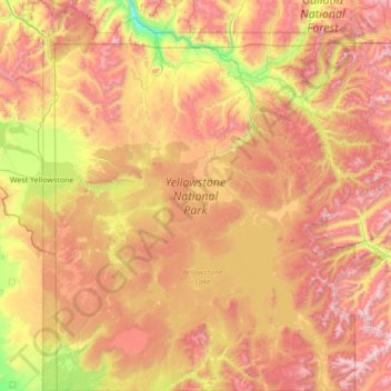
Name: Yellowstone National Park topographic map, elevation, terrain.
Location: Yellowstone National Park, Wyoming, United States (44.13158 -111.15599 45.10896 -109.82549)
Average elevation: 2,450 m
Minimum elevation: 1,560 m
Maximum elevation: 3,549 m
Other topographic maps
Click on a map to view its topography, its elevation and its terrain.
Goshen County Fair Grounds
United States > Wyoming > Goshen County > Torrington
Average elevation: 1,258 m
Laramie
United States > Wyoming > Albany County
Laramie (/ˈlærəmi/) is a city in and the county seat of Albany County, Wyoming, United States, known for its high elevation at 7,200 feet (2,200 m), for its railroad history, and as the home of the University of Wyoming. The population was 31,407 at the 2020 census, making it the fourth-most populous city…
Average elevation: 2,218 m
Laramie
United States > Wyoming > Albany County
Laramie (/ˈlærəmi/) is a city in and the county seat of Albany County, Wyoming, United States, known for its high elevation at 7,200 feet (2,200 m), railroad history, and is the home of the University of Wyoming. The population was 31,407 at the 2020 census, making it the fourth-most populous city in…
Average elevation: 2,218 m
Rocky Mountains
United States > Wyoming > Teton County
Agriculture and forestry are major industries. Agriculture includes dryland and irrigated farming and livestock grazing. Livestock are frequently moved between high-elevation summer pastures and low-elevation winter pastures, a practice known as transhumance.
Average elevation: 2,292 m
Gannett Peak
United States > Wyoming > Fremont County
Gannett Peak is the highest mountain peak in the U.S. state of Wyoming at 13,810 feet (4,210 m). It lies in the Wind River Range within the Bridger Wilderness of the Bridger-Teton National Forest. Straddling the Continental Divide along the boundary between Fremont and Sublette counties, it has the second…
Average elevation: 3,700 m
World's Largest Mineral Hot Spring
United States > Wyoming > Hot Springs County > Thermopolis
Average elevation: 1,360 m
Jenny Lake
United States > Wyoming > Teton County
Jenny Lake is a starting point for many day and overnight hiking trips. The 7.1-mile (11.4 km) Jenny Lake Trail loops around the lake and is considered to be relatively easy due to the small altitude gain of 700 feet (210 m). However, the altitude increases rapidly once Cascade Canyon is entered.
Average elevation: 2,109 m
Cloud Peak
United States > Wyoming > Big Horn County
It rises to an elevation of 13,171 feet (4,015 m) and provides onlookers with dramatic views and vistas. The mountain can be climbed most easily from the western side, accessed by either the Battle Park or West Tensleep trail-heads and is roughly 24 miles round-trip from both. The peak is located in the…
Average elevation: 3,598 m
Casper Mountain
United States > Wyoming > Natrona County
Casper Mountain, an anticline, is located at the north end of the Laramie Mountains overlooking Casper, Wyoming along the North Platte River. At a top elevation of 8,130 feet (2,478 m), the geological feature rises approximately 3,000 feet (914 m) above Casper.
Average elevation: 2,315 m
Worland
United States > Wyoming > Washakie County > Worland
Worland experiences an arid climate (Köppen BWk), but one which is quite distinct from much of the state. Due to the location within the Big Horn Basin, it is protected from severe weather by the surrounding mountains from nearly every direction. This topography results in weather that is highly continental…
Average elevation: 1,319 m
Laramie
United States > Wyoming > Albany County > Laramie
Laramie is on a high plain between two mountain ranges, the Snowy Range, about 30 miles (48 km) to the west, and the Laramie Range, 7 miles (11 km) to the east. The city's elevation above sea level is approximately 7,165 feet (2,184 m). The Laramie River runs through Laramie toward its confluence with the…
Average elevation: 2,299 m
Pinedale
United States > Wyoming > Sublette County
Pinedale is located at 42°51′58″N 109°51′53″W / 42.86611°N 109.86472°W / 42.86611; -109.86472 (42.866162, −109.864622) and sits at an elevation of 7,175 feet above sea level. According to the United States Census Bureau, the town has a total area of 2.15 square miles (5.57 km2), all of it land.
Average elevation: 2,199 m
Upper Geyser Basin
United States > Wyoming > Teton County > Upper Geyser Basin
Average elevation: 2,295 m