
Dakshina Kannada topographic map
Interactive map
Click on the map to display elevation.
Dakshina Kannada
The topography of the district is plain up to 30 km (18.64 mi) inside the coast and changes to undulating hilly terrain sharply towards the east in the Western Ghats. Teak, bamboo and rosewood trees are found in the hilly areas towards the east. The Geological Survey of India has identified this district as a moderately earthquake-prone region and categorised it in the Seismic III Zone. In rural Dakshina Kannada, houses are in the midst of a farm field or plantations of coconut or arecanut, separated by a few hundred metres.
About this map
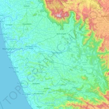
Name: Dakshina Kannada topographic map, elevation, terrain.
Location: Dakshina Kannada, Dakshina Kannada district, Karnataka, India (12.46010 74.77071 13.18335 75.67280)
Average elevation: 109 m
Minimum elevation: -2 m
Maximum elevation: 1,862 m
Other topographic maps
Click on a map to view its topography, its elevation and its terrain.
Bengaluru
India > Karnataka > Bangalore North
Bangalore (/ˈbæŋɡəlɔːr, ˌbæŋɡəˈlɔːr/ BANG-gə-lor, -LOR), officially Bengaluru (Kannada pronunciation: [ˈbeŋgɐɭuːɾu] ), is the capital and largest city of the southern Indian state of Karnataka. It has a population of more than 8 million and a metropolitan population of around 15…
Average elevation: 879 m
Karkala
India > Karnataka > Karkala taluk
Karla is located at 13°12′N 74°59′E / 13.2°N 74.98°E / 13.2; 74.98. It has an average elevation of 81 metres (265 feet).
Average elevation: 80 m
Shikaripura
India > Karnataka > Shikaripura taluk
Shikaripur is located at 14°16′N 75°21′E / 14.27°N 75.35°E / 14.27; 75.35. It has an average elevation of 603 m (1978 ft). It lies on tropical forests of Malenadu region. Shikaripura is one of the junction to connect north karnataka to Malenadu. And the river kumadvati flows from the town and…
Average elevation: 610 m
Chincholi
India > Karnataka > Chincholi taluku
Chincholi is located at 17°28′N 77°26′E / 17.47°N 77.43°E / 17.47; 77.43. It has an average elevation of 462 m (1,516 ft). The town is spread over an area of 6 km2 (2.3 sq mi).
Average elevation: 466 m
Kalaghatagi
India > Karnataka > Kalaghatagi taluku
Kalghatgi is located at 15°11′N 74°58′E / 15.18°N 74.97°E / 15.18; 74.97. It has an average elevation of 536 metres (1758 feet). Kalghatgi is located 28 km from Hubli and 30 km from Dharwad.The Kalghatgi town is located on National Highway 63 (India) en route from Hubli to Ankola.
Average elevation: 545 m
Krishnaraja Sagara
India > Karnataka > Krishnarajanagara taluk > Yaraganahalli
Average elevation: 769 m
Raichur
India > Karnataka > Rayachuru taluku
Raichur is located at 16°12′N 77°22′E / 16.2°N 77.37°E / 16.2; 77.37 on Deccan plateau. It has an average elevation of 407 metres (1335 ft)
Average elevation: 378 m
Ranganathittu Bird Sanctuary
India > Karnataka > Srirangapattana taluk > Krishnarajasagara
Average elevation: 736 m