
South East England topographic map
Interactive map
Click on the map to display elevation.
South East England
Near Weybridge are the UK headquarters of Sony with SSP Group (situated in Byfleet) and Procter & Gamble (next door to each other on The Heights Business Park near the former Brooklands racing circuit) with Kia Motors UK and Petroleum Geo-Services UK, and Gallaher Group (cigarettes) is to the north, next to the Brooklands Museum; to the east is Verint Systems UK on the B374. In Weybridge are the local newspaper group Newsquest, Yamaha Motors UK; BAE Systems Regional Aircraft is on the Brooklands Ind Park off the A318 (since 2001 it has no longer manufactured). On Sprint Ind Est in Byfleet, west of Weybridge, off the A318, AIM Altitude (former Henshalls) make cabin galleys for airliners. The Central Veterinary Laboratory, which is run by the Veterinary Laboratories Agency, with the Animal and Plant Health Agency, is in New Haw to the west on the other side of the M25. Mouchel is in West Byfleet.
About this map
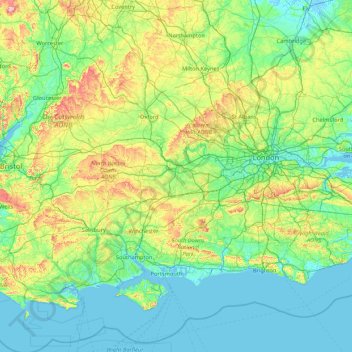
Name: South East England topographic map, elevation, terrain.
Location: South East England, England, United Kingdom (50.57468 -1.95728 52.19632 1.45177)
Average elevation: 69 m
Minimum elevation: -3 m
Maximum elevation: 491 m
England trails, hiking, mountain biking, running and outdoor activities
Other topographic maps
Click on a map to view its topography, its elevation and its terrain.
Reading
United Kingdom > England > Reading
Mary Russell Mitford lived in Reading for a number of years and then spent the rest of her life just outside the town at Three Mile Cross and Swallowfield. The fictional Belford Regis of her eponymous novel, first published in 1835, is largely based on Reading. Described with topographical accuracy, it is…
Average elevation: 56 m
St Albans
United Kingdom > England > Hertfordshire > St Albans
St Albans was an ancient borough created following the dissolution of the monastery in 1539. It consisted of the ancient parish of St Albans (also known as the Abbey parish) and parts of St Michael and St Peter. The municipal corporation was reformed by the Municipal Corporations Act 1835 and the boundary was…
Average elevation: 100 m
Peterborough
United Kingdom > England > Cambridgeshire
The local topography is flat, and in some places, the land lies below sea level, for example in parts of the Fens to the east and to the south of Peterborough. Human settlement in the area began before the Bronze Age, as can be seen at the Flag Fen archaeological site to the east of the current city centre,…
Average elevation: 17 m
Richmond
United Kingdom > England > London
The town centre lies just below 33 ft (10m) above sea level. South of the town centre, rising from Richmond Bridge to an elevation of 165 ft (50m), is Richmond Hill. Just beyond the summit of Richmond Hill is Richmond Park, an area of 2,360 acres (9.55 km2; 3.7 sq mi) of wild heath and woodland originally…
Average elevation: 17 m
Leeds
Lying in the eastern foothills of the Pennines, there is a significant variation in elevation within the city's built-up area. The district ranges from 1,115 feet (340 m) in the far west on the slopes of Ilkley Moor to about 33 feet (10 m) where the rivers Aire and Wharfe cross the eastern boundary. Land rises…
Average elevation: 94 m
Cambridge
United Kingdom > England > Cambridge
The city, like most of the UK, has a maritime climate highly influenced by the Gulf Stream. Located in the driest region of Britain, Cambridge's rainfall averages around 570 mm (22.44 in) per year, around half the national average, with some years occasionally falling into the semi-arid (under 500 mm (19.69…
Average elevation: 18 m
Stoney Littleton
United Kingdom > England > Bath and North East Somerset > Shoscombe
Average elevation: 116 m
City of London
United Kingdom > England > City of London > City of London
The elevation of the City ranges from sea level at the Thames to 21.6 metres (71 ft) at the junction of High Holborn and Chancery Lane. Two small but notable hills are within the historic core, Ludgate Hill to the west and Cornhill to the east. Between them ran the Walbrook, one of the many "lost" rivers or…
Average elevation: 42 m
Hull
United Kingdom > England > Kingston upon Hull
Kingston upon Hull is on the northern bank of the Humber Estuary. The city centre is west of the River Hull and close to the Humber. The city is built upon alluvial and glacial deposits which overlie chalk rocks but the underlying chalk has no influence on the topography. The land within the city is generally…
Average elevation: 21 m
Plymouth
United Kingdom > England > Devon > Plymouth
The River Plym, which flows off Dartmoor to the north-east, forms a smaller estuary to the east of the city called Cattewater. Plymouth Sound is protected from the sea by the Plymouth Breakwater, in use since 1814. In the Sound is Drake's Island which is seen from Plymouth Hoe, a flat public area on top of…
Average elevation: 81 m
Bedford
United Kingdom > England > Bedford
As with the rest of the United Kingdom, Bedford has a maritime climate, with a limited range of temperatures, and generally even rainfall throughout the year. The nearest Met Office weather station to Bedford is Bedford (Thurleigh) airport, about 6.5 miles (10.5 km) north of Bedford town centre at an elevation…
Average elevation: 37 m
Cufaude
United Kingdom > England > Hampshire > Basingstoke and Deane > Bramley
Average elevation: 69 m
Swindon
United Kingdom > England > Swindon
Swindon has an oceanic climate (Cfb in the Köppen climate classification), like the vast majority of the British Isles, with cool winters and warm summers. The nearest official weather station is RAF Lyneham, about 10 miles (16 km) west southwest of Swindon town centre. The weather station's elevation is 145…
Average elevation: 108 m
Holbeach Marsh
United Kingdom > England > Lincolnshire > South Holland > Holbeach CP > Holbeach St Marks
Average elevation: 4 m
Tottenham
Tottenham's elevation is approximately 33 ft (10 m) above sea level.
Average elevation: 25 m
Staunton Harold Reservoir
United Kingdom > England > Derbyshire > South Derbyshire > Melbourne CP
Average elevation: 93 m
Blea Tarn
United Kingdom > England > Cumberland > Boot > Beckfoot
Blea Tarn is a lake in Eskdale, Cumbria, in the English Lake District, located about half a mile north of Beckfoot. Located at an elevation of 217 m (712 ft), the lake has an area of 3.3 hectares (8.2 acres) and measures 277 m × 150 m (909 ft × 492 ft), with a maximum depth of 11 m (36 ft).
Average elevation: 144 m
Former Seaton Ironworks Reservoir (disused)
United Kingdom > England > Cumberland > Workington > Stainburn
Average elevation: 32 m
Cellarhead
United Kingdom > England > Staffordshire > Staffordshire Moorlands
Average elevation: 240 m