
Lang Son province topographic map
Interactive map
Click on the map to display elevation.
About this map
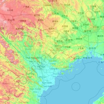
Name: Lang Son province topographic map, elevation, terrain.
Location: Lang Son province, Vietnam (19.25670 103.84244 24.45670 109.04244)
Average elevation: 445 m
Minimum elevation: -2 m
Maximum elevation: 3,044 m
The province is set in karstic limestone mountains and valleys. Mountains and forests comprise 80% of the province's area. The province measures approximately 123 kilometres from north to south and 126 kilometres from west to east. The average altitude of the province is 252 metres (827 ft) above sea level. The lowest point in the province is 20 metres (66 ft) towards the south of Hữu Lũng District and the highest point is at Mount Mẫu Sơn, which is 1,541 metres (5,056 ft). Mẫu Sơn is to the east of the town of Lạng Sơn by 30 kilometres (19 mi), and is surrounded by a series of small peaks; snow sometimes falls on these peaks in winter. The Bac Son Mountains are located in the province and are calcareous in nature. Fertile valleys are framed by high mountain ridges, creating a scenic landscape.
Other topographic maps
Click on a map to view its topography, its elevation and its terrain.
Phá Tam Giang
Vietnam > Thừa Thiên Huế Province > Quảng Điền District > Sia
Phá Tam Giang, Sia, Quảng Điền District, Thừa Thiên Huế Province, Vietnam
Average elevation: 2 m
Chanh My Ward
Vietnam > Binh Duong province > Thủ Dầu Một
Chanh My Ward, Thủ Dầu Một, Bình Dương Province, Vietnam
Average elevation: 9 m
Phú Giáo District
Phú Giáo District, Bình Dương Province, Vietnam
Average elevation: 55 m
Xã Tân Hòa
Vietnam > Tra Vinh province > Tiểu Cần District
Xã Tân Hòa, Tiểu Cần District, Trà Vinh Province, Vietnam
Average elevation: 3 m
Gia Ninh
Vietnam > Quang Binh province > Quảng Ninh District
Gia Ninh, Quảng Ninh District, Quảng Bình Province, Vietnam
Average elevation: 9 m
Mường Ảng District
Mường Ảng District, Điện Biên Province, Vietnam
Average elevation: 930 m
Dalat
Vietnam > Lâm Đồng Province > Dalat
Dalat, Đà Lạt District, Lâm Đồng Province, 6700, Vietnam
Average elevation: 1,360 m
Scenic Viewpoint
Vietnam > Ninh Binh province > Hoa Lư District > Tam Cốc
Scenic Viewpoint, Thai Vi, Tam Cốc, Hoa Lư District, Ninh Bình Province, 08213, Vietnam
Average elevation: 27 m
Công viên Tao Đàn
Vietnam > Kien Giang Province > Hà Tiên
Công viên Tao Đàn, Khu phố 5, Phường Bình San, Hà Tiên, Kiên Giang Province, Vietnam
Average elevation: 6 m
Núi Pha Luông
Vietnam > Son La province > Mộc Châu District
Núi Pha Luông, Mộc Châu District, Sơn La Province, Vietnam
Average elevation: 1,399 m
Xã Bình Khánh
Xã Bình Khánh, Can Gio District, Ho Chi Minh City, Vietnam
Average elevation: 2 m
Xã Bình Khánh
Vietnam > Bến Tre Province > Mỏ Cày Nam District
Xã Bình Khánh, Mỏ Cày Nam District, Bến Tre Province, Vietnam
Average elevation: 3 m
Long Hoa Commune
Long Hoa Commune, Can Gio District, Ho Chi Minh City, Vietnam
Average elevation: 1 m
Detian Falls
Vietnam > Cao Bang province > Trùng Khánh District
Detian Falls, Trùng Khánh District, Cao Bằng Province, Vietnam
Average elevation: 483 m
Xã Phước Thiền
Vietnam > Dong Nai province > Nhơn Trạch District
Xã Phước Thiền, Nhơn Trạch District, Đồng Nai Province, Vietnam
Average elevation: 11 m
Nhơn Trạch District
Nhơn Trạch District, Đồng Nai Province, Vietnam
Average elevation: 6 m
Xã Hòa Ninh
Xã Hòa Ninh, Hòa Vang District, Đà Nẵng, Vietnam
Average elevation: 108 m
Công viên Bùi Thị Xuân
Vietnam > Thừa Thiên Huế Province > Huế
Công viên Bùi Thị Xuân, Phường Phường Đúc, Huế, Thừa Thiên Huế Province, Vietnam
Average elevation: 9 m
Ban Co Peak
Ban Co Peak, Đường Lê Văn Lương, Phường Thọ Quang, Sơn Trà District, Đà Nẵng, 50207, Vietnam
Average elevation: 308 m
Hà Rai
Vietnam > Phu Yen province > Đồng Xuân District
Hà Rai, Đồng Xuân District, Phú Yên Province, Vietnam
Average elevation: 73 m
Vũng Tàu
Vietnam > Bà Rịa - Vũng Tàu Province
Vũng Tàu, Bà Rịa - Vũng Tàu Province, Vietnam
Average elevation: 3 m
Landing Zone X-Ray
Vietnam > Gia Lai Province > Chư Prông District
Landing Zone X-Ray, Quốc lộ 14C, Chư Prông District, Gia Lai Province, Vietnam
Average elevation: 229 m
Yên Thủy District
Yên Thủy District, Hoà Bình province, Vietnam
Average elevation: 125 m
Phường 10
Vietnam > Lâm Đồng Province > Da Lat City
Phường 10, Da Lat City, Lâm Đồng Province, Vietnam
Average elevation: 1,399 m
Dong Hoa
Vietnam > Binh Duong province > Di An City > Di An
Dong Hoa, Dĩ An, Di An City, Bình Dương Province, Vietnam
Average elevation: 25 m
Quang Bình District
Quang Bình District, Hà Giang Province, Vietnam
Average elevation: 409 m
Thành phố Tân Uyên
Thành phố Tân Uyên, Bình Dương Province, 75409, Vietnam
Average elevation: 30 m
Tây Ninh City
Tây Ninh City, Tây Ninh Province, Vietnam
Average elevation: 28 m
Hương Khê District
Hương Khê District, Hà Tĩnh Province, 46003, Vietnam
Average elevation: 262 m
Hoc Mon District
Hoc Mon District, Ho Chi Minh City, Vietnam
Average elevation: 5 m
Ngọc Lặc District
Ngọc Lặc District, Thanh Hoá Province, Vietnam
Average elevation: 104 m
Đầm Thị Nại
Vietnam > Bình Định Province > Tuy Phước District > Hải Minh
Đầm Thị Nại, Hải Minh, Tuy Phước District, Bình Định Province, Vietnam
Average elevation: 20 m
Phường Xuân Bình
Vietnam > Dong Nai province > Long Khánh City
Phường Xuân Bình, Long Khánh City, Đồng Nai Province, Vietnam
Average elevation: 177 m
Phường Quan Hoa
Phường Quan Hoa, Cau Giay District, Hà Nội, Vietnam
Average elevation: 12 m
M'Đrắk
Vietnam > Đắk Lắk province > M'Đrăk District
M'Đrắk, M'Đrăk District, Đăk Lăk Province, Vietnam
Average elevation: 451 m
Ben Cau
Vietnam > Tay Ninh province > Ben Cau District
Ben Cau, Ben Cau District, Tây Ninh Province, Vietnam
Average elevation: 7 m
A Lưới District
Vietnam > Thừa Thiên Huế Province
A Lưới District, Thừa Thiên Huế Province, Vietnam
Average elevation: 581 m
Núi Nứa
Vietnam > Bà Rịa - Vũng Tàu Province > Chau Duc District > Xuan Son Commune
Núi Nứa, Xuan Son Commune, Chau Duc District, Bà Rịa - Vũng Tàu Province, Vietnam
Average elevation: 78 m