
Keith County topographic map
Interactive map
Click on the map to display elevation.
About this map
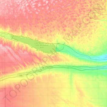
Name: Keith County topographic map, elevation, terrain.
Location: Keith County, Nebraska, United States (41.00347 -102.05557 41.39594 -101.24803)
Average elevation: 1,044 m
Minimum elevation: 913 m
Maximum elevation: 1,189 m
Other topographic maps
Click on a map to view its topography, its elevation and its terrain.
Bellevue
United States > Nebraska > Sarpy County
Bellevue is located at an elevation of 1159 ft (353 m). According to the United States Census Bureau, the city has a total area of 16.02 square miles (41.49 km2), of which 15.85 square miles (41.05 km2) is land and 0.17 square miles (0.44 km2) is water. It is bounded on the east by the Missouri River.
Average elevation: 310 m
Fremont
United States > Nebraska > Dodge County
According to the United States Census Bureau, the city has a total area of 8.85 square miles (22.92 km2), of which 8.80 square miles (22.79 km2) is land and 0.05 square miles (0.13 km2) is water. Fremont lies in the river plain between the Platte and Elkhorn rivers, at an elevation of approximately 366 meters…
Average elevation: 365 m
Columbus
United States > Nebraska > Platte County
The city lies at an elevation of 1,447 feet (441 m). It is built on the flat terrain of the Platte River valley; rolling hills rise to the north of the city.
Average elevation: 442 m
De Soto National Wildlife Refuge
United States > Nebraska > Washington County
Average elevation: 306 m
Fremont
United States > Nebraska > Dodge County > Fremont
According to the United States Census Bureau, the city has a total area of 8.85 square miles (22.92 km2), of which 8.80 square miles (22.79 km2) is land and 0.05 square miles (0.13 km2) is water. Fremont lies in the river plain between the Platte and Elkhorn rivers, at an elevation of approximately 366 meters…
Average elevation: 378 m