
California topographic map
Interactive map
Click on the map to display elevation.
About this map
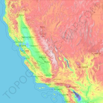
Name: California topographic map, elevation, terrain.
Location: California, United States (32.52952 -124.48200 42.00950 -114.13078)
Average elevation: 929 m
Minimum elevation: -82 m
Maximum elevation: 4,095 m
California's mountains produce rain shadows on the eastern side, creating extensive deserts. The higher elevation deserts of eastern California have hot summers and cold winters, while the low deserts east of the Southern California mountains have hot summers and nearly frostless mild winters. Death Valley, a desert with large expanses below sea level, is considered the hottest location in the world; the highest temperature in the world, 134 °F (56.7 °C), was recorded there on July 10, 1913. The lowest temperature in California was −45 °F (−43 °C) on January 20, 1937, in Boca.
Other topographic maps
Click on a map to view its topography, its elevation and its terrain.
Houston
United States > Texas > Harris County
Houston, Harris County, Texas, United States
Average elevation: 25 m
Jacksonville
United States > Florida > Duval County
Jacksonville, Duval County, Florida, United States
Average elevation: 10 m
Brooklyn
United States > New York > New York
Brooklyn, Kings County, New York, United States
Average elevation: 9 m
Montgomery County
Montgomery County, Texas, United States
Average elevation: 69 m
Riverside County
Riverside County, California, United States
Average elevation: 538 m
Charlotte County
Charlotte County, Florida, United States
Average elevation: 10 m
Joshua Tree National Park
Joshua Tree National Park, California, United States
Average elevation: 639 m
Appalachian Mountains
United States > North Carolina > Yancey County
Appalachian Mountains, Yancey County, North Carolina, United States
Average elevation: 1,463 m
City of Albany
United States > New York > Albany County
City of Albany, Albany County, New York, United States
Average elevation: 68 m
Norfolk
United States > Virginia > Norfolk
Norfolk, Virginia, 23510, United States
Average elevation: 4 m
New Orleans
United States > Louisiana > Orleans Parish
New Orleans, Orleans Parish, Louisiana, United States
Average elevation: 1 m
Nashville-Davidson
United States > Tennessee > Davidson County
Nashville-Davidson, Davidson County, Middle Tennessee, Tennessee, United States
Average elevation: 184 m
Tampa
United States > Florida > Hillsborough County
Tampa, Hillsborough County, Florida, United States
Average elevation: 11 m
Fort Worth
United States > Texas > Tarrant County
Fort Worth, Tarrant County, Texas, United States
Average elevation: 212 m
Staten Island
United States > New York > New York
Staten Island, Richmond County, New York, United States
Average elevation: 9 m
Boston
United States > Massachusetts > Suffolk County
Boston, Suffolk County, Massachusetts, United States
Average elevation: 25 m
Indianapolis
United States > Indiana > Indianapolis
Indianapolis, Marion County, Indiana, 46204, United States
Average elevation: 241 m
Hudson River
Hudson River, New Jersey, 12834:12871, United States
Average elevation: 297 m
Hillsborough County
Hillsborough County, Florida, United States
Average elevation: 20 m