
Make a donation
Gear up for your next adventure:
As an Amazon Associate, this site earns from qualifying purchases at no extra cost to you.
Andaman and Nicobar Islands topographic map
Click on the map to display elevation.
Make a donation
Gear up for your next adventure:
As an Amazon Associate, this site earns from qualifying purchases at no extra cost to you.
Andaman and Nicobar Islands
The islands have a 1,962 km (1,219 mi) long coast-line. The topography of the territory varies significantly across various islands. The islands may have sandy, rocky sandstone or marshy beaches on the coastlines and might be surrounded by shoals and coral reefs. The altitude varies significantly from completely flat islands to gradually raising topography from the coast to the interior in larger islands. The islands are generally surrounded by shallow seas of varying depths in the vicinity with some deep natural bays occurring along certain coasts. The islands have a moderate temperature around the year with the average ranging from 23 °C to 31 °C. The islands have a tropical climate with warm summers and not so chill winters. The rainfall is dependent on the monsoons and tropical cyclones are common in late summer.
Make a donation
Gear up for your next adventure:
As an Amazon Associate, this site earns from qualifying purchases at no extra cost to you.
About this map
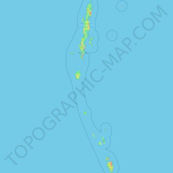
Name: Andaman and Nicobar Islands topographic map, elevation, terrain.
Location: Andaman and Nicobar Islands, India (6.75627 92.20421 13.67531 94.27732)
Average elevation: 1 m
Minimum elevation: 0 m
Maximum elevation: 625 m
Make a donation
Gear up for your next adventure:
As an Amazon Associate, this site earns from qualifying purchases at no extra cost to you.
Other topographic maps
Click on a map to view its topography, its elevation and its terrain.
Vadodara
India > Gujarat > Vadodara Rural Taluka
Vadodara is located at 22°18′N 73°11′E / 22.30°N 73.19°E / 22.30; 73.19 in western India at an elevation of 39 metres (128 ft). It is the tenth-largest city in India with an area of 400 square kilometres (150 sq mi) and a population of 3.5 million, according to the 2010–11 census. The city…
Average elevation: 36 m
Make a donation
Gear up for your next adventure:
As an Amazon Associate, this site earns from qualifying purchases at no extra cost to you.
Mysuru
India > Karnataka > Mysuru taluk
Mysore (/maɪˈsɔːr/ (listen)), officially Mysuru ([ˈmaɪˈsuːɾu] (listen)), is a city in the southern part of the state of Karnataka, India. Mysore city is geographically located between 12° 18′ 26″ north latitude and 76° 38′ 59″ east longitude. It is located at an altitude of 770 m (2,530 ft)…
Average elevation: 727 m
Thiruvananthapuram
India > Kerala > Thiruvananthapuram
Thiruvananthapuram is built on seven hills by the seashore and is at 8°30′N 76°54′E / 8.5°N 76.9°E / 8.5; 76.9 on the west coast, near the southern tip of mainland India. The city is on the west coast of India and is bounded by the Laccadive Sea to its west and the Western Ghats to its east.…
Average elevation: 33 m
Make a donation
Gear up for your next adventure:
As an Amazon Associate, this site earns from qualifying purchases at no extra cost to you.
Bhubaneshwar
India > Odisha > Bhubaneswar (M.Corp.)
Bhubaneswar is in Khordha district of Odisha. It is in the eastern coastal plains, along the axis of the Eastern Ghats mountains. The city has an average altitude of 45 m (148 ft) above sea level. It lies southwest of the Mahanadi River that forms the northern boundary of Bhubaneswar metropolitan area, within…
Average elevation: 30 m
Mumbai
Mumbai lies at the mouth of the Ulhas River on the western coast of India, in the coastal region known as the Konkan. It sits on Salsette Island (Sashti Island), which it partially shares with the Thane district. Mumbai is bounded by the Arabian Sea to the west. Many parts of the city lie just above sea level,…
Average elevation: 13 m
Maharashtra
Maharashtra is the third largest state by area in India. The Western Ghats better known as Sahyadri, are a hilly range running parallel to the coast, at an average elevation of 1,200 metres (4,000 ft). Kalsubai, a peak in the Sahyadris, near Nashik city is the highest elevated point in Maharashtra. To the west…
Average elevation: 478 m
Make a donation
Gear up for your next adventure:
As an Amazon Associate, this site earns from qualifying purchases at no extra cost to you.
Guwahati
Professor Abani Kumar Bhagawati of Gauhati University stated that since before there were sufficient wetlands to absorb rainwater and channels to carry excess water to the Brahmaputra, the city did not experience floods. However, human interference has disrupted the natural topography, leading to the current…
Average elevation: 113 m
Make a donation
Gear up for your next adventure:
As an Amazon Associate, this site earns from qualifying purchases at no extra cost to you.
Kalaburagi
India > Karnataka > Kalaburagi taluku
The entire district is on the Deccan Plateau, and the elevation ranges from 300 to 750 m above MSL. Two main rivers, the Krishna and Bhima, flow through the district. The predominant soil type is black soil. The district has many tanks, which irrigate the land along with the river. The Upper Krishna Project is…
Average elevation: 465 m
Make a donation
Gear up for your next adventure:
As an Amazon Associate, this site earns from qualifying purchases at no extra cost to you.
Make a donation
Gear up for your next adventure:
As an Amazon Associate, this site earns from qualifying purchases at no extra cost to you.
Bokaro
Bokaro district consists of undulating uplands on the Chota Nagpur Plateau with the Damodar River cutting a valley right across. It has an average elevation of 200 to 540 metres (660 to 1,770 ft) above mean sea level. The highest hill, Lugu Pahar, rises to a height of 1,070 metres (3,510 ft). The East Bokaro…
Average elevation: 232 m
Leh
Leh (/ˈlɛ/) (Ladakhi: གླེ) is the joint capital and largest city of Ladakh, a union territory of India. Leh, located in the Leh district, was also the historical capital of the Kingdom of Ladakh, the seat of which was in the Leh Palace, the former residence of the royal family of Ladakh, built in the…
Average elevation: 4,294 m
Visakhapatnam
India > Andhra Pradesh > Visakhapatnam (Urban)
The city is situated between the Eastern Ghats and the Bay of Bengal. The city coordinates lies between 17.7041 N and 83.2977 E. The city's area is 682 km2. The average elevation is 45 metres. Visakhpatnam is situated in Coastal Andhra Region.
Average elevation: 35 m
Make a donation
Gear up for your next adventure:
As an Amazon Associate, this site earns from qualifying purchases at no extra cost to you.
Make a donation
Gear up for your next adventure:
As an Amazon Associate, this site earns from qualifying purchases at no extra cost to you.
Make a donation
Gear up for your next adventure:
As an Amazon Associate, this site earns from qualifying purchases at no extra cost to you.
Make a donation
Gear up for your next adventure:
As an Amazon Associate, this site earns from qualifying purchases at no extra cost to you.
Make a donation
Gear up for your next adventure:
As an Amazon Associate, this site earns from qualifying purchases at no extra cost to you.
Make a donation
Gear up for your next adventure:
As an Amazon Associate, this site earns from qualifying purchases at no extra cost to you.
Bir
India > Himachal Pradesh > Baijnath
The paragliding launch site is in the meadow at Billing (14 km north of Bir), at an elevation of 2400 meters, while the landing site and most tourist accommodations are in the village of Chowgan (also spelled Chaugan), on the southern edge of Bir.
Average elevation: 1,628 m
Vagamon
Vagamon, due to its elevation and climate, has a unique ecosystem, leading to the emergence of rich natural vegetation, plant species, shola forests etc. From the early 20th century plantation crops like tea, coffee started. Vagamon hills are home to less explored flora and fauna. A faunal diversity study…
Average elevation: 866 m
Make a donation
Gear up for your next adventure:
As an Amazon Associate, this site earns from qualifying purchases at no extra cost to you.
Patna
India > Bihar > Patna Rural
Patna is on the southern bank of the river Ganges. The total area of Patna is 250 km2 (97 sq mi). Of this, the municipal area constitutes 109.218 km2 (42.169 sq mi). The suburban area covers 140.782 km2 (54.356 sq mi). It has an average elevation of 53 m (174 ft). A characteristic feature of the geography of…
Average elevation: 51 m
Surat
India > Gujarat > Katargam Taluka > Surat
Surat is a port city situated on the banks of the Tapi river. Damming of the Tapi caused the original port facilities to close; the nearest port is now in the Magadalla and Hazira area of Surat Metropolitan Region.It has famous beach called 'Dumas Beach' located in Hazira. The city is located at 21°10′N…
Average elevation: 11 m
Make a donation
Gear up for your next adventure:
As an Amazon Associate, this site earns from qualifying purchases at no extra cost to you.
Rupnagar
India > Punjab > Rupnagar Tahsil
Rupnagar is located at 30°58′N 76°32′E / 30.97°N 76.53°E / 30.97; 76.53. It has an average elevation of 260 metres (850 ft). The town lies on the bank of Satluj River and the Shivalik hill range spreads along the opposite bank of the river.
Average elevation: 281 m
Gundlupet
India > Karnataka > Gundlupet taluk
Gundlupet is located at 11°48′N 76°41′E / 11.8°N 76.68°E / 11.8; 76.68. It has an average elevation of 816 metres (2,677 feet).
Average elevation: 807 m
Make a donation
Gear up for your next adventure:
As an Amazon Associate, this site earns from qualifying purchases at no extra cost to you.
Make a donation
Gear up for your next adventure:
As an Amazon Associate, this site earns from qualifying purchases at no extra cost to you.
Arani
India > Tamil Nadu > Arani
Arni is located at 12°40′N 79°17′E / 12.67°N 79.28°E / 12.67; 79.28 on the banks of the Kamandala Naaga river. It has an average elevation of 151 metres (495 ft).
Average elevation: 143 m
Make a donation
Gear up for your next adventure:
As an Amazon Associate, this site earns from qualifying purchases at no extra cost to you.
Make a donation
Gear up for your next adventure:
As an Amazon Associate, this site earns from qualifying purchases at no extra cost to you.
Make a donation
Gear up for your next adventure:
As an Amazon Associate, this site earns from qualifying purchases at no extra cost to you.
Kolhapur
India > Maharashtra > Karvir
Kolhapur is an inland city located in south-west Maharashtra state, 373 km (232 mi) south of Mumbai and 228 km (142 mi) south of Pune, 615 km (382 mi) north-west of Bengaluru and 530 km (330 mi) west of Hyderabad. Within Maharashtra, Kolhapur's nearest cities and towns are Ichalkaranji 27 km (17 mi), Kodoli 35…
Average elevation: 592 m
Make a donation
Gear up for your next adventure:
As an Amazon Associate, this site earns from qualifying purchases at no extra cost to you.
Make a donation
Gear up for your next adventure:
As an Amazon Associate, this site earns from qualifying purchases at no extra cost to you.
Mussoorie
India > Uttarakhand > Dehradun
Mussoorie is at an average altitude of 2,005 metres (6,578 ft). To the northeast are the Himalayan snow ranges, and to the south, the Doon Valley and Shiwalik ranges. The second highest point is the original Lal Tibba in Landour, with a height of over 2,275 m (7,464 ft). Mussoorie is popularly known as The…
Average elevation: 1,594 m
Prayagraj
India > Uttar Pradesh > Prayagraj
Prayagraj's elevation is over 90 m (295 ft) above sea level. The old part of the city, at the south of Prayagraj Junction railway station, consists of neighbourhoods like Chowk, Johnstongunj, Dariyabad, Khuldabad and many more. In the north of the Railway Station, the new city consists of neighbourhoods like…
Average elevation: 91 m
Make a donation
Gear up for your next adventure:
As an Amazon Associate, this site earns from qualifying purchases at no extra cost to you.
Siliguri
India > West Bengal > Matigara block
Siliguri located at the foothills of the eastern Himalayas at a location of 26°43′N 88°26′E / 26.71°N 88.43°E / 26.71; 88.43. This city is spread over an area of 260 km2 within the Siliguri Corridor, also known as the Chicken's neck. The city is surrounded by dense forests towards north and…
Average elevation: 121 m
Make a donation
Gear up for your next adventure:
As an Amazon Associate, this site earns from qualifying purchases at no extra cost to you.
Anand
India > Gujarat > Anand City Taluka
Anand is located at 22°34′N 72°56′E / 22.57°N 72.93°E / 22.57; 72.93. It has an average elevation of 39 metres (127 feet). The city has an area of 22.7 square kilometres, and the urban area of Anand City is 172 square kilometres including 25 villages around the city.
Average elevation: 40 m
Kurnool
India > Andhra Pradesh > Kurnool
Kurnool is located at 15°50′00″N 78°03′00″E / 15.8333°N 78.05°E / 15.8333; 78.05. It has an average elevation of 273 metres (898 feet). Kurnool lies on the banks of the Tungabhadra River. The Hundri and Neeva rivers also flow through the city. The K.C.Canal (Kurnool–Cuddapah) was built…
Average elevation: 307 m
Dehradun
India > Uttarakhand > Dehradun
The city of Dehradun mainly lies in Doon Valley and is at a varying height from 410 m (1,350 ft) in Clement Town to above 700 m (2,300 ft) at Malsi which is 15 km (9.3 mi) from the city. However, the average elevation is 450 m (1,480 ft) above sea level. Malsi is the starting point of Lesser Himalayan Range…
Average elevation: 904 m
Make a donation
Gear up for your next adventure:
As an Amazon Associate, this site earns from qualifying purchases at no extra cost to you.
Salem
Salem is located at 11°40′N 78°08′E / 11.67°N 78.14°E / 11.67; 78.14, at an average elevation of 278 m (912 ft). The city is surrounded by hills: Nagaramalai on the north, Jarugumalai on the south, Kanjamalai on the west, Godumalai on the east and the Shevaroy Hills on the northeast.…
Average elevation: 418 m
Make a donation
Gear up for your next adventure:
As an Amazon Associate, this site earns from qualifying purchases at no extra cost to you.