
Neno topographic map
Interactive map
Click on the map to display elevation.
About this map
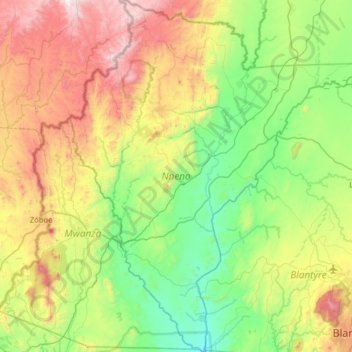
Name: Neno topographic map, elevation, terrain.
Location: Neno, Southern Region, Malawi, Malawi (-15.81952 34.49239 -15.20781 35.04847)
Average elevation: 684 m
Minimum elevation: 185 m
Maximum elevation: 1,724 m
Other topographic maps
Click on a map to view its topography, its elevation and its terrain.
Kasungu National Park
Kasungu National Park, Kasungu, Central Region, Malawi, Malawi
Average elevation: 1,087 m
Nkhotakota
Malawi > Nkhotakota > Nkhotakota
Nkhotakota, Central Region, Malawi, Malawi
Average elevation: 487 m
Uzumara Forest Reserve
Uzumara Forest Reserve, M1, Mojowa, Rumphi, Northern Region, Malawi
Average elevation: 1,687 m
Lake Chilwa
Lake Chilwa, Zomba, Southern Region, Malawi
Average elevation: 647 m