Geolocate

Hussainabad topographic map

Interactive map

Click on the map to display elevation.

About this map

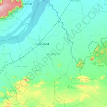
Name: Hussainabad topographic map, elevation, terrain.

Location: Hussainabad, Palamu District, Jharkhand, 822116, India (24.36852 83.93168 24.64376 84.11579)

Average elevation: 191 m

Minimum elevation: 118 m

Maximum elevation: 591 m

Other topographic maps

Click on a map to view its topography, its elevation and its terrain.

Ranchi

India > Jharkhand > Kanke

Ranchi lies at 23°22′N 85°20′E / 23.36°N 85.33°E / 23.36; 85.33 near to the Tropic of Cancer. The city covers an area of 175 km2 (68 sq mi) and its average elevation is 651 m above sea level. Ranchi is located in the southern part of the Chota Nagpur plateau, which is the eastern section of…

Average elevation: 648 m

South Karo River

India > Jharkhand > Tonto

Average elevation: 343 m

Mandar

India > Jharkhand

Average elevation: 684 m

IEL Gomia

India > Jharkhand > Gumia

Gumia is located at 23°48′38″N 85°49′24″E / 23.8106°N 85.8232°E / 23.8106; 85.8232. It has an average elevation of 238 metres (780 feet) and lies within the deciduous forests of Chota Nagpur Plateau

Average elevation: 279 m

Bundu

India > Jharkhand

Average elevation: 384 m

Ramna

India > Jharkhand

Average elevation: 272 m

Chainpur

India > Jharkhand

Average elevation: 288 m

By Pass

India > Jharkhand > Keredari

Average elevation: 452 m

Jaduguda

India > Jharkhand > Musabani

Average elevation: 148 m

Juljul

India > Jharkhand > Hazaribagh > Hazaribagh

Average elevation: 615 m

Maheshpur

India > Jharkhand

Average elevation: 68 m

Dubia

India > Jharkhand > Palojori

Average elevation: 261 m

Ukri

India > Jharkhand > Saraikela > Sini

Average elevation: 165 m

Kadambera

India > Jharkhand > Saraikela

Average elevation: 186 m

Sagma

India > Jharkhand

Average elevation: 292 m

Telo

India > Jharkhand > Borio

Average elevation: 80 m

Chhatarpur

India > Jharkhand

Average elevation: 281 m

Tirla

India > Jharkhand > Erki(Tamar II)

Average elevation: 603 m

Sahibganj

India > Jharkhand > Sahibganj (block)

Average elevation: 73 m

Pakaur

India > Jharkhand > Pakaur

Average elevation: 34 m

Betla

India > Jharkhand > Barwadih

Average elevation: 297 m

Bhawānipur

India > Jharkhand > Chas > Chas

Average elevation: 214 m

Pipra

India > Jharkhand

Average elevation: 213 m

Jarhi

India > Jharkhand > Dandai

Average elevation: 262 m

Mandu

India > Jharkhand

Average elevation: 455 m

Bishrampur

India > Jharkhand

Average elevation: 207 m

Netarhat

India > Jharkhand > Mahuadanr

Average elevation: 1,033 m

Giridih

India > Jharkhand > Giridih

Giridih is located at 24°11′N 86°18′E / 24.18°N 86.3°E / 24.18; 86.3. It has an average elevation of 289 metres (948 ft). Śrī Sammed Shikharji also known as the Parasnath Hills, located in Giridih district is the highest mountain peak in Jharkhand. It is a conical granite peak located 4,477…

Average elevation: 292 m

Dhanbad

India > Jharkhand > Dhanbad-Cum-Kenduadih-Cum-Jagata

Dhanbad has an average elevation of 227 m (745 ft). Its geographical length (extending from north to south) is 15 miles (24 km) and the breadth (stretching across east to West) is 10 miles (16 km). It shares its boundaries with West Bengal in the eastern and southern part, Dumka and Giridih in the North and…

Average elevation: 212 m

Garu

India > Jharkhand

Average elevation: 587 m

Gumia

India > Jharkhand

Average elevation: 374 m

Jamshedpur

India > Jharkhand > Golmuri-Cum-Jugsalai

Jamshedpur is situated in the southern end of the state of Jharkhand and is bordered by the states of Odisha and West Bengal. The average elevation of the city is 135 metres while the range is from 129 m to 151 m. Total geographical area of Jamshedpur is 224 km square. Jamshedpur is primarily located in a…

Average elevation: 195 m

Silwai

India > Jharkhand > Namkum

Average elevation: 603 m

Lakra Dewani

India > Jharkhand > Jama

Average elevation: 148 m

Alampur

India > Jharkhand > Rajmahal

Average elevation: 29 m

Kamo

India > Jharkhand > Chauparan

Average elevation: 396 m

Dumri

India > Jharkhand > Dumri

Average elevation: 293 m

Marwa

India > Jharkhand > Borio

Average elevation: 111 m

Dharampur

India > Jharkhand > Rajmahal

Average elevation: 28 m

Bātto

India > Jharkhand > Dumri

Average elevation: 335 m

Bhandro

India > Jharkhand > Dumri

Average elevation: 313 m

Pathara

India > Jharkhand > Borio > Pathra

Average elevation: 86 m

Moti Jharna

India > Jharkhand > Taljhari > Maharajpur

Average elevation: 92 m

Motijharna Falls

India > Jharkhand > Taljhari > Darkala

Average elevation: 166 m

Amrapali Gate 1

India > Jharkhand > Tandwa

Average elevation: 473 m

Barkagaon

India > Jharkhand

Average elevation: 491 m

Lewa

India > Jharkhand > Borio

Average elevation: 172 m

Kharaundhi

India > Jharkhand

Average elevation: 214 m

Kander

India > Jharkhand > Erki(Tamar II)

Average elevation: 583 m

Kolhua

India > Jharkhand > Pathargama

Average elevation: 75 m