
Ohio River topographic map
Interactive map
Click on the map to display elevation.
About this map
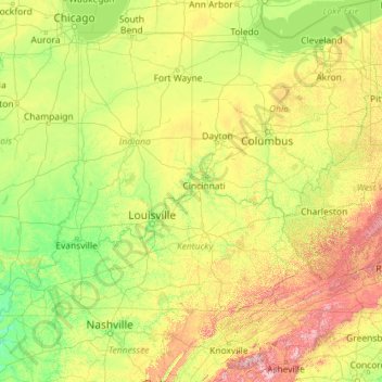
Name: Ohio River topographic map, elevation, terrain.
Location: Ohio River, United States (36.98350 -89.17727 40.69668 -80.01712)
Average elevation: 293 m
Minimum elevation: 79 m
Maximum elevation: 1,945 m
The river became a primary transportation route for pioneers during the westward expansion of the early U.S. The lower Ohio River just below Louisville was obstructed by rapids known as the Falls of the Ohio where the elevation falls 26 feet (7.9 m) in 2 miles (3.2 km) restricting larger commercial navigation, although in the 18th and early 19th century its three deepest channels could be traversed by a wide variety of craft then in use. In 1830, the Louisville and Portland Canal (now the McAlpine Locks and Dam) bypassed the rapids, allowing even larger commercial and modern navigation from the Forks of the Ohio at Pittsburgh to the Port of New Orleans at the mouth of the Mississippi on the Gulf of Mexico. Since the "canalization" of the river in 1929, the Ohio has not been a natural free-flowing river; today, it is divided into 21 discrete pools or reservoirs by 20 locks and dams for navigation and power generation.
Other topographic maps
Click on a map to view its topography, its elevation and its terrain.
Houston
United States > Texas > Harris County
Houston, Harris County, Texas, United States
Average elevation: 25 m
Montgomery County
Montgomery County, Texas, United States
Average elevation: 69 m
The Woodlands
United States > Texas > Montgomery County
The Woodlands, Montgomery County, Texas, United States
Average elevation: 47 m
Boulder
United States > Colorado > Boulder County
Boulder, Boulder County, Colorado, United States
Average elevation: 1,785 m
Brooklyn
United States > New York > New York
Brooklyn, Kings County, New York, United States
Average elevation: 9 m
New Orleans
United States > Louisiana > Orleans Parish
New Orleans, Orleans Parish, Louisiana, United States
Average elevation: 1 m
Yosemite National Park
Yosemite National Park, California, United States
Average elevation: 2,337 m
Knoxville
United States > Tennessee > Knox County
Knoxville, Knox County, East Tennessee, Tennessee, United States
Average elevation: 307 m
Fort Worth
United States > Texas > Tarrant County
Fort Worth, Tarrant County, Texas, United States
Average elevation: 212 m
Appalachian Mountains
United States > North Carolina > Yancey County
Appalachian Mountains, Yancey County, North Carolina, United States
Average elevation: 1,463 m
Lexington
United States > Kentucky > Lexington
Lexington, Fayette County, Kentucky, 40508, United States
Average elevation: 285 m
Spokane
United States > Washington > Spokane County
Spokane, Spokane County, Washington, United States
Average elevation: 655 m
Santa Barbara
United States > California > Santa Barbara County
Santa Barbara, Santa Barbara County, California, United States
Average elevation: 119 m
Sequoia National Park
United States > California > Tulare County
Sequoia National Park, Tulare County, California, United States
Average elevation: 2,515 m
Brunswick County
United States > North Carolina
Brunswick County, North Carolina, United States
Average elevation: 9 m
Staten Island
United States > New York > New York
Staten Island, Richmond County, New York, United States
Average elevation: 9 m