
Ganges topographic map
Interactive map
Click on the map to display elevation.
About this map
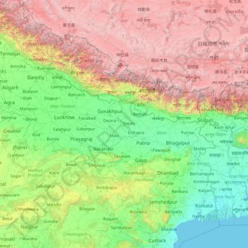
Name: Ganges topographic map, elevation, terrain.
Location: Ganges, India (22.38351 78.03340 30.14509 91.20155)
Average elevation: 1,673 m
Minimum elevation: -2 m
Maximum elevation: 8,096 m
The upper phase of the river Ganges begins at the confluence of the Bhagirathi and Alaknanda rivers in the town of Devprayag in the Garhwal division of the Indian state of Uttarakhand. The Bhagirathi is considered to be the source in Hindu culture and mythology, although the Alaknanda is longer, and therefore, hydrologically the source stream. The headwaters of the Alakananda are formed by snow melt from peaks such as Nanda Devi, Trisul, and Kamet. The Bhagirathi rises at the foot of Gangotri Glacier, at Gomukh, at an elevation of 4,356 m (14,291 ft) and being mythologically referred to as residing in the matted locks of Shiva; symbolically Tapovan, which is a meadow of ethereal beauty at the feet of Mount Shivling, just 5 km (3.1 mi) away.
Other topographic maps
Click on a map to view its topography, its elevation and its terrain.
Bengaluru
India > Karnataka > Bangalore North
Bengaluru, Bangalore North, Bengaluru Urban District, Karnataka, India
Average elevation: 881 m
Chennai
India > Tamil Nadu > Chennai
Chennai, Chennai District, Tamil Nadu, India
Average elevation: 8 m
Pune
India > Maharashtra > Pune City > Pune
Pune, Pune City, Pune District, Maharashtra, 411001, India
Average elevation: 641 m
3d
India > Rajasthan > Ganganagar Tehsil > 1 LNP
3d, 1 LNP, Ganganagar Tehsil, Sri Ganganagar District, Rajasthan, India
Average elevation: 178 m
Lucknow
India > Uttar Pradesh > Lucknow
Lucknow, Lucknow District, Uttar Pradesh, 226027, India
Average elevation: 120 m
Mysuru
India > Karnataka > Mysuru taluk
Mysuru, Mysuru taluk, Mysuru District, Karnataka, 570001, India
Average elevation: 727 m
Kolkata
Kolkata, Kolkata District, West Bengal, 700073, India
Average elevation: 5 m
Bachupally mandal
Bachupally mandal, Medchal–Malkajgiri District, Telangana, 500090, India
Average elevation: 593 m
Tehri-Garhwal
Tehri-Garhwal, Tehri Garhwal District, Uttarakhand, 249125, India
Average elevation: 2,339 m
Chhota Bhanuja
India > Rajasthan > Khamnor Tehsil
Chhota Bhanuja, Khamnor Tehsil, Rajsamand District, Rajasthan, 313321, India
Average elevation: 644 m
Chikodi taluk
Chikodi taluk, Belagavi District, Karnataka, India
Average elevation: 613 m
Nathdwara
India > Rajasthan > Nathdwara Tehsil
Nathdwara, Nathdwara Tehsil, Rajsamand District, Rajasthan, 313301, India
Average elevation: 590 m
Kukshi
India > Madhya Pradesh > Kukshi Tahsil > Kukshi
Kukshi, Kukshi Tahsil, Dhar District, Madhya Pradesh, 454331, India
Average elevation: 176 m
Thoothukudi
India > Tamil Nadu > Thoothukkudi
Thoothukudi, Thoothukkudi, Thoothukudi District, Tamil Nadu, 628001, India
Average elevation: 10 m
North Sentinel Island
India > Andaman and Nicobar Islands > Ferrargunj
North Sentinel Island, Ferrargunj, South Andaman District, Andaman and Nicobar Islands, India
Average elevation: 20 m
Gurgaon
India > Haryana > Gurugram District
Gurgaon, Gurugram District, Haryana, India
Average elevation: 237 m
Rampur Bushahr
India > Himachal Pradesh > Rampur
Rampur Bushahr, Rampur, Shimla district, Himachal Pradesh, India
Average elevation: 1,715 m
Thiruvananthapuram
India > Kerala > Thiruvananthapuram
Thiruvananthapuram, Thiruvananthapuram District, Kerala, 695001, India
Average elevation: 33 m
Coimbatore
India > Tamil Nadu > Coimbatore North
Coimbatore, Coimbatore North, Coimbatore District, Tamil Nadu, 641001, India
Average elevation: 452 m
Chiephobozou
India > Nagaland > Chiephobozou
Chiephobozou, Kohima District, Nagaland, 797105, India
Average elevation: 1,189 m
Narhe
India > Maharashtra > Bhor
Narhe, Bhor, Pune District, Maharashtra, India
Average elevation: 683 m
Darlaghat
Darlaghat, Solan District, Himachal Pradesh, India
Average elevation: 1,261 m
Kukshi
India > Madhya Pradesh > Bhavra Tehsil
Kukshi, Bhavra Tehsil, Alirajpur District, Madhya Pradesh, India
Average elevation: 403 m
Sehore
India > Madhya Pradesh > Sehore Nagar Tahsil
Sehore, Sehore Nagar Tahsil, Sehore District, Madhya Pradesh, 466002, India
Average elevation: 501 m
Panaiyur
India > Tamil Nadu > Mannargudi
Panaiyur, Mannargudi, Thiruvarur District, Tamil Nadu, 614717, India
Average elevation: 7 m
Hanagal taluk
Hanagal taluk, Haveri District, Karnataka, India
Average elevation: 571 m
Whitefield
India > Karnataka > Bangalore East > Bengaluru
Whitefield, Bengaluru, Bangalore East, Bengaluru Urban District, Karnataka, 560066, India
Average elevation: 875 m