
Khartoum State topographic map
Interactive map
Click on the map to display elevation.
About this map
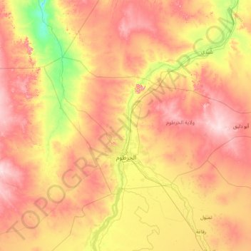
Name: Khartoum State topographic map, elevation, terrain.
Location: Khartoum State, Sudan (15.16736 31.62306 16.63134 34.40350)
Average elevation: 426 m
Minimum elevation: 312 m
Maximum elevation: 603 m
Other topographic maps
Click on a map to view its topography, its elevation and its terrain.
Marrah
The two lakes at Deriba, as described by Hobbs' 1918 notes, were presumably the only two in Jebel Marra. Hobbs situated them at an altitude of approximately 518 m (1700 feet, as indicated in his note) above the plain and 1,463 m (4,804 feet) above sea level (modern measurements, however, indicate 2100 m). They…
Average elevation: 2,682 m