
Tombouctou Cercle topographic map
Interactive map
Click on the map to display elevation.
About this map
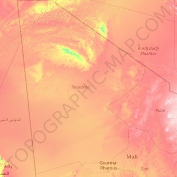
Name: Tombouctou Cercle topographic map, elevation, terrain.
Location: Tombouctou Cercle, Taoudénit Region, Mali (16.60211 -6.57188 25.00108 -0.02137)
Average elevation: 317 m
Minimum elevation: 129 m
Maximum elevation: 725 m
Other topographic maps
Click on a map to view its topography, its elevation and its terrain.
Taoudeni
Taoudenni is a remote site in the hottest region on the planet, located over a hundred and sixty kilometres from the nearest inhabited location of any size. The region is located in the middle of the Sahara Desert, in the southern part of the Tanezrouft (one of the harshest areas on the planet, known for…
Average elevation: 141 m