
Kaski topographic map
Interactive map
Click on the map to display elevation.
Kaski
The district, with Pokhara as its district headquarter, covers an area of 2,017 square km and had a total population of 492,098 according to 2011 Census. This district lies at the centroid point of the country. The altitude of Kaski district ranges from 450 meters the lowest land to 8091 meters the highest point in the Himalaya range. Kaski District politically has One Metropolitan City, 4 Gaupalika and 3 electoral sectors.
About this map
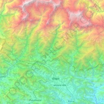
Name: Kaski topographic map, elevation, terrain.
Location: Kaski, Gandaki Province, Nepal (28.07773 83.69944 28.61295 84.27848)
Average elevation: 2,565 m
Minimum elevation: 381 m
Maximum elevation: 8,006 m
Other topographic maps
Click on a map to view its topography, its elevation and its terrain.
Machapuchare
Nepal > Gandaki Province > Kaski
Due to its southern position in the range and the particularly low terrain that lies south of the Annapurna Himalayas, which contains three of the 10 highest peaks in the world, Machapuchare commands tremendous vertical relief in a short horizontal distance. This, combined with its steep, pointed profile,…
Average elevation: 5,746 m