
Nalut topographic map
Interactive map
Click on the map to display elevation.
About this map
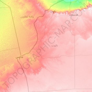
Name: Nalut topographic map, elevation, terrain.
Location: Nalut, Libya (28.84050 9.39108 32.35417 11.94672)
Average elevation: 473 m
Minimum elevation: 89 m
Maximum elevation: 796 m
Nalut District is located in the north western part of Libya, called Tripolitania. Most of the country has a flat undulating plain and occasional plateau, with an average elevation of around 423 m (1,388 ft). Around 91 per cent of the land is covered by desert, with only 8.8 per cent agricultural land (with only 1% arable lands) and 0.1 per cent of forests. The major resources are petroleum, gypsum and natural gas. Along the coastal regions, the climate is Mediterranean in coastal areas, while it is desert climate in all other parts. Dust storms lasting four to eight days is pretty common during Spring.[3] Triplotania is the northwest region, while it is Cyrenacia in the east and Fezzen in southwest.[4] Triplotania runs from north to south and has set of coastal oases, plains and limestone plateaus having an elevation of 2,000 ft (610 m) to 3,000 ft (910 m). The region receives an annual rainfall of 16 in (410 mm). There are no perennial rivers in the region, but the region is abundant with groundwater aquifers.[5]
Other topographic maps
Click on a map to view its topography, its elevation and its terrain.
Qabilat az Zintan al `Umyan
Qabilat az Zintan al `Umyan, Jabal al Gharbi, Libya
Average elevation: 544 m
Old city of Tripoli
Old city of Tripoli, Tripoli, Libya
Average elevation: 7 m
dar bin sweedan
Libya > Jafara > Al-Nasiriyya
dar bin sweedan, Al-Nasiriyya, Jafara, Libya
Average elevation: 94 m
Bi`r Abu al Ghurab
Libya > Jabal al Gharbi > Bi`r Abu al Ghurab
Bi`r Abu al Ghurab, Jabal al Gharbi, Libya
Average elevation: 332 m
Al Fuqaha`
Libya > District of Al-Jufra > Al Fuqaha`
Al Fuqaha`, District of Al-Jufra, Libya
Average elevation: 534 m
Awlad `Isa
Libya > Jabal al Gharbi > Awlad `Isa
Awlad `Isa, Jabal al Gharbi, Libya
Average elevation: 689 m
Temzghurah
Libya > Jabal al Gharbi > Temzghurah
Temzghurah, Jabal al Gharbi, Libya
Average elevation: 565 m
Suknah
Libya > District of Al-Jufra > Suknah
Suknah, District of Al-Jufra, Libya
Average elevation: 295 m
Al Sahqeeqa
Libya > Jabal al Gharbi > Al Sahqeeqa
Al Sahqeeqa, Jabal al Gharbi, Libya
Average elevation: 595 m
Awlad Abd al Jalil
Libya > Jabal al Gharbi > Awlad Abd al Jalil
Awlad Abd al Jalil, Jabal al Gharbi, Libya
Average elevation: 639 m
Winzeref wa Alibashna
Libya > Jabal al Gharbi > Winzeref wa Alibashna
Winzeref wa Alibashna, Jabal al Gharbi, Libya
Average elevation: 605 m