
Make a donation
Gear up for your next adventure:
As an Amazon Associate, this site earns from qualifying purchases at no extra cost to you.
Atiwa East District topographic map
Click on the map to display elevation.
Make a donation
Gear up for your next adventure:
As an Amazon Associate, this site earns from qualifying purchases at no extra cost to you.
About this map
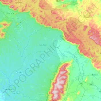
Name: Atiwa East District topographic map, elevation, terrain.
Location: Atiwa East District, Eastern Region, Ghana (6.27858 -0.88669 6.51255 -0.46080)
Average elevation: 316 m
Minimum elevation: 135 m
Maximum elevation: 830 m
Make a donation
Gear up for your next adventure:
As an Amazon Associate, this site earns from qualifying purchases at no extra cost to you.
Other topographic maps
Click on a map to view its topography, its elevation and its terrain.
Aburi
Ghana > Eastern Region > Akuapim South District
Due to the altitude of Aburi, the climate is a lot cooler than neighbouring Accra. The road which climbs the hillside to Aburi is a toll road, with the current toll being 0.50 Ghc for a car, 1.00 Ghc for a 4x4.
Average elevation: 277 m
Make a donation
Gear up for your next adventure:
As an Amazon Associate, this site earns from qualifying purchases at no extra cost to you.
Make a donation
Gear up for your next adventure:
As an Amazon Associate, this site earns from qualifying purchases at no extra cost to you.
Aburi
Ghana > Eastern Region > Akuapim South District
Due to the altitude of Aburi, the climate is a lot cooler than neighbouring Accra. The road which climbs the hillside to Aburi is a toll road, with the current toll being 0.50 Ghc for a car, 1.00 Ghc for a 4x4.
Average elevation: 277 m
Make a donation
Gear up for your next adventure:
As an Amazon Associate, this site earns from qualifying purchases at no extra cost to you.
Make a donation
Gear up for your next adventure:
As an Amazon Associate, this site earns from qualifying purchases at no extra cost to you.
Make a donation
Gear up for your next adventure:
As an Amazon Associate, this site earns from qualifying purchases at no extra cost to you.
Make a donation
Gear up for your next adventure:
As an Amazon Associate, this site earns from qualifying purchases at no extra cost to you.
Make a donation
Gear up for your next adventure:
As an Amazon Associate, this site earns from qualifying purchases at no extra cost to you.
New Juaben North Municipality
Ghana > Eastern Region > New Juaben North Municipal District > New Juaben North Municipality
Average elevation: 182 m
Mpraeso
Ghana > Eastern Region > Kwahu South District
Mpraeso is a town and the capital of Kwahu South district, a district in the Eastern Region of south Ghana, located at an altitude of 367 m on the Kwahu Plateau, which forms the south-west boundary of Lake Volta. Mpraeso has a 2013 settlement population of 11,190 people.
Average elevation: 486 m
Make a donation
Gear up for your next adventure:
As an Amazon Associate, this site earns from qualifying purchases at no extra cost to you.