
South Carolina topographic map
Interactive map
Click on the map to display elevation.
About this map
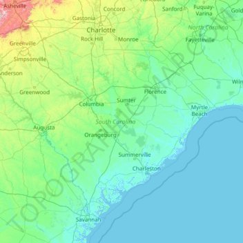
Name: South Carolina topographic map, elevation, terrain.
Location: South Carolina, United States (32.03345 -83.35400 35.21549 -78.54135)
Average elevation: 85 m
Minimum elevation: -4 m
Maximum elevation: 1,642 m
The Atlantic Coastal plain consists of sediments and sedimentary rocks that range in age from Cretaceous to Present. The terrain is relatively flat and the soil is composed predominantly of sand, silt, and clay. Areas with better drainage make excellent farmland, though some land is swampy. An unusual feature of the coastal plain is a large number of low-relief topographic depressions named Carolina bays. The bays tend to be oval, lining up in a northwest to southeast orientation. The eastern portion of the coastal plain contains many salt marshes and estuaries, as well as natural ports such as Georgetown and Charleston. The natural areas of the coastal plain are part of the Middle Atlantic coastal forests ecoregion.
Other topographic maps
Click on a map to view its topography, its elevation and its terrain.
Madison
United States > Wisconsin > Dane County
Madison, Dane County, Wisconsin, United States
Average elevation: 284 m
Central Park
United States > New York > New York County > New York
Central Park, New York County, New York, United States
Average elevation: 26 m
Fort Lauderdale
United States > Florida > Broward County
Fort Lauderdale, Broward County, Florida, United States
Average elevation: 5 m
New Orleans
United States > Louisiana > Orleans Parish
New Orleans, Orleans Parish, Louisiana, United States
Average elevation: 1 m
Ruidoso
United States > New Mexico > Lincoln County
Ruidoso, Lincoln County, New Mexico, United States
Average elevation: 2,287 m
Hillsborough County
Hillsborough County, Florida, United States
Average elevation: 20 m
Sacramento
United States > California > Sacramento County
Sacramento, Sacramento County, California, United States
Average elevation: 10 m
Highlands Ranch
United States > Colorado > Douglas County
Highlands Ranch, Douglas County, Colorado, 80126, United States
Average elevation: 1,758 m
Breckenridge
United States > Colorado > Summit County
Breckenridge, Summit County, Colorado, 80424, United States
Average elevation: 3,072 m
Staten Island
United States > New York > New York
Staten Island, Richmond County, New York, United States
Average elevation: 9 m
Lehigh County
Lehigh County, Pennsylvania, United States
Average elevation: 186 m
Parker
United States > Colorado > Douglas County
Parker, Douglas County, Colorado, 80134, United States
Average elevation: 1,845 m
Kitsap County
Kitsap County, Washington, United States
Average elevation: 138 m
Norfolk
United States > Virginia > Norfolk
Norfolk, Virginia, 23510, United States
Average elevation: 4 m
Texarkana
United States > Texas > Bowie County
Texarkana, Bowie County, Texas, United States
Average elevation: 99 m
Brooklyn
United States > New York > New York
Brooklyn, Kings County, New York, United States
Average elevation: 9 m
Chula Vista
United States > California > San Diego County
Chula Vista, San Diego County, California, United States
Average elevation: 42 m
Toledo
United States > Ohio > Lucas County
Toledo, Lucas County, Ohio, United States
Average elevation: 187 m
Houston
United States > Texas > Harris County
Houston, Harris County, Texas, United States
Average elevation: 25 m
Buffalo
United States > New York > Erie County
Buffalo, Erie County, New York, United States
Average elevation: 185 m
New Smyrna Beach
United States > Florida > Volusia County
New Smyrna Beach, Volusia County, Florida, United States
Average elevation: 3 m
East Lansing
United States > Michigan > Ingham County
East Lansing, Ingham County, Michigan, United States
Average elevation: 261 m