Geolocate

Gear up for your next adventure:

As an Amazon Associate, this site earns from qualifying purchases at no extra cost to you.

👉 Easily get elevation data in JSON, GeoTIFF and KML formats using Elevation API
Thank you for supporting this site ❤️
Make a donation

Scotland topographic map

Click on the map to display elevation.

Gear up for your next adventure:

As an Amazon Associate, this site earns from qualifying purchases at no extra cost to you.

Gear up for your next adventure:

As an Amazon Associate, this site earns from qualifying purchases at no extra cost to you.

👉 Easily get elevation data in JSON, GeoTIFF and KML formats using Elevation API
Thank you for supporting this site ❤️
Make a donation

Scotland

Scotland's topography is a tapestry of rugged mountains, rolling hills, and expansive coastlines. The Highlands, occupying the northern and western regions, are characterized by towering peaks such as Ben Nevis, the UK's highest at 1,345 meters, and deep glens carved by ancient glaciers. The Grampian Mountains, including the Cairngorms, present a mix of rounded summits and plateaus, offering a stark contrast to the jagged Cuillin range on the Isle of Skye. Southward, the Central Lowlands, or Midland Valley, feature undulating hills and fertile plains, while the Southern Uplands boast gentle, rolling hills that descend towards the Solway Firth. Scotland's extensive coastline is deeply indented with sea lochs and dotted with numerous islands, each displaying unique geological features. This diverse terrain not only shapes the country's natural beauty but also influences its climate, vegetation, and human settlement patterns.

Gear up for your next adventure:

As an Amazon Associate, this site earns from qualifying purchases at no extra cost to you.

👉 Easily get elevation data in JSON, GeoTIFF and KML formats using Elevation API
Thank you for supporting this site ❤️
Make a donation

About this map

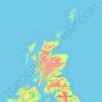
Name: Scotland topographic map, elevation, terrain.

Location: Scotland, United Kingdom (54.43398 -14.01552 61.06100 -0.32092)

Average elevation: 36 m

Minimum elevation: 0 m

Maximum elevation: 1,259 m

United Kingdom trails, hiking, mountain biking, running and outdoor activities

Gear up for your next adventure:

As an Amazon Associate, this site earns from qualifying purchases at no extra cost to you.

👉 Easily get elevation data in JSON, GeoTIFF and KML formats using Elevation API
Thank you for supporting this site ❤️
Make a donation

Other topographic maps

Click on a map to view its topography, its elevation and its terrain.

London

United Kingdom > England > London

Average elevation: 42 m

Telford

United Kingdom > England > Telford and Wrekin

Average elevation: 136 m

Leicester

United Kingdom > England > Leicestershire

Average elevation: 109 m

Gear up for your next adventure:

As an Amazon Associate, this site earns from qualifying purchases at no extra cost to you.

Thank you for supporting this site ❤️
Make a donation

Derby

United Kingdom > England > Derbyshire

Average elevation: 96 m

Leeds

United Kingdom > England

Lying in the eastern foothills of the Pennines, there is a significant variation in elevation within the city's built-up area. The district ranges from 1,115 feet (340 m) in the far west on the slopes of Ilkley Moor to about 33 feet (10 m) where the rivers Aire and Wharfe cross the eastern boundary. Land rises…

Average elevation: 94 m

Halifax

United Kingdom > England > Calderdale

Topographically, Halifax is located in the south-eastern corner of the moorland region called the South Pennines. Halifax is situated about 4 miles (6 km) from the M62 motorway, close to Bradford and Huddersfield. The A641 road links the town with Brighouse, Bradford and Huddersfield. The Hebble Brook joins…

Average elevation: 195 m

Wrexham

United Kingdom > Wales > Wrexham

Average elevation: 139 m

United Kingdom

United Kingdom

Scotland accounts for just under a third (32 per cent) of the total area of the UK, covering 78,772 square kilometres (30,410 sq mi). This includes nearly eight hundred islands, predominantly west and north of the mainland; notably the Hebrides, Orkney Islands and Shetland Islands. Scotland is the most…

Average elevation: 79 m

Matlock

United Kingdom > England > Derbyshire > Derbyshire Dales

Average elevation: 213 m

Aberdeen

United Kingdom > Scotland > Aberdeen

Two weather stations collect climate data for the area, Aberdeen/Dyce Airport, and Craibstone. Both are about 4 1⁄2 miles (7 km) to the north west of the city centre, and given that they are in close proximity to each other, exhibit very similar climatic regimes. Dyce tends to have marginally warmer daytime…

Average elevation: 52 m

Carluke

United Kingdom > Scotland > South Lanarkshire

Average elevation: 191 m

Gear up for your next adventure:

As an Amazon Associate, this site earns from qualifying purchases at no extra cost to you.

Thank you for supporting this site ❤️
Make a donation

South Shields

United Kingdom > England > Tyne and Wear > South Tyneside

The current town was founded in 1245 and developed as a fishing port. The name South Shields developed from the 'Schele' or 'Shield', which was a small dwelling used by fishermen. Another industry that was introduced was that of salt-panning, later expanded upon in the 15th century, polluting the air and…

Average elevation: 23 m

Rowley Regis

United Kingdom > England > Sandwell

Average elevation: 155 m

Huddersfield

United Kingdom > England > Kirklees

Average elevation: 145 m

Macclesfield

United Kingdom > England > Macclesfield

Average elevation: 189 m

Gear up for your next adventure:

As an Amazon Associate, this site earns from qualifying purchases at no extra cost to you.

Thank you for supporting this site ❤️
Make a donation

Hebden Bridge

United Kingdom > England > Calderdale

Average elevation: 277 m

Abergavenny

United Kingdom > Wales > Monmouthshire

Average elevation: 187 m

Cardiff

United Kingdom > Wales > Cardiff

Average elevation: 55 m

Edinburgh

United Kingdom > Scotland > Edinburgh

Some have called Edinburgh the Athens of the North for a variety of reasons. The earliest comparison between the two cities showed that they had a similar topography, with the Castle Rock of Edinburgh performing a similar role to the Athenian Acropolis. Both of them had flatter, fertile agricultural land…

Average elevation: 104 m

Oak Green

United Kingdom > England > Cheshire East > Wilmslow

Average elevation: 82 m

Gear up for your next adventure:

As an Amazon Associate, this site earns from qualifying purchases at no extra cost to you.

Thank you for supporting this site ❤️
Make a donation

Llanelli

United Kingdom > Wales > Carmarthenshire

Average elevation: 41 m

Carmarthen

United Kingdom > Wales > Carmarthenshire

Average elevation: 74 m

Gear up for your next adventure:

As an Amazon Associate, this site earns from qualifying purchases at no extra cost to you.

Thank you for supporting this site ❤️
Make a donation

Glossop

United Kingdom > England > Derbyshire > High Peak

Average elevation: 284 m

Portsmouth

United Kingdom > England > Hampshire > Portsmouth

By road, Portsmouth lies 73.5 miles (118.3 km) from Central London, 49.5 miles (79.7 km) west of Brighton, and 22.3 miles (35.9 km) east of Southampton. Portsmouth is situated primarily on Portsea Island and is the United Kingdom's only island city, although parts of it have expanded onto the mainland. Gosport…

Average elevation: 28 m

Basingstoke

United Kingdom > England > Hampshire > Basingstoke and Deane

Situated in a valley through the Hampshire Downs at an average elevation of 88 metres (289 ft) Basingstoke is a major interchange between Reading, Newbury, Andover, Winchester, and Alton, and lies on the natural trade route between the southwest of England and London. The area had been something of an…

Average elevation: 110 m

Aviemore

United Kingdom > Scotland > Highland

Average elevation: 331 m

Melton Mowbray

United Kingdom > England > Leicestershire > Melton

Average elevation: 103 m

Gear up for your next adventure:

As an Amazon Associate, this site earns from qualifying purchases at no extra cost to you.

Thank you for supporting this site ❤️
Make a donation

Swansea

United Kingdom > Wales > Swansea

Much of Swansea is hilly with the main area of upland being located in the council ward of Mawr. Areas up to 185 metres (607 ft) in elevation range across the central section: Kilvey Hill, Townhill and Llwynmawr separate the centre of Swansea from its northern suburbs. Cefn Bryn, a ridge of high land, is the…

Average elevation: 73 m

Newport

United Kingdom > Wales > Newport

Average elevation: 89 m

Brighton

United Kingdom > England > Brighton and Hove

Average elevation: 64 m

Swindon

United Kingdom > England > Swindon

Swindon has an oceanic climate (Cfb in the Köppen climate classification), like the vast majority of the British Isles, with cool winters and warm summers. The nearest official weather station is RAF Lyneham, about 10 miles (16 km) west southwest of Swindon town centre. The weather station's elevation is 145…

Average elevation: 108 m

Peterborough

United Kingdom > England > Cambridgeshire

The local topography is flat, and in some places, the land lies below sea level, for example in parts of the Fens to the east and to the south of Peterborough. Human settlement in the area began before the Bronze Age, as can be seen at the Flag Fen archaeological site to the east of the current city centre,…

Average elevation: 17 m

Gear up for your next adventure:

As an Amazon Associate, this site earns from qualifying purchases at no extra cost to you.

Thank you for supporting this site ❤️
Make a donation

Eglwys-bach

United Kingdom > Wales > Conwy

Average elevation: 139 m

Brynithel

United Kingdom > Wales > Blaenau Gwent

Average elevation: 288 m

Dingestow

United Kingdom > Wales > Monmouthshire

Average elevation: 64 m

Bilston

United Kingdom > England > Wolverhampton

Average elevation: 148 m

Gilfachrheda

United Kingdom > Wales > Ceredigion > Llanarth

Average elevation: 87 m

Gear up for your next adventure:

As an Amazon Associate, this site earns from qualifying purchases at no extra cost to you.

Thank you for supporting this site ❤️
Make a donation

Brinsop

United Kingdom > England > Herefordshire

Average elevation: 110 m

Gwaelod-y-garth

United Kingdom > Wales > Cardiff

Average elevation: 124 m

Pentridge

United Kingdom > England > Dorset

Average elevation: 113 m

Pencombe

United Kingdom > England > Herefordshire

Average elevation: 171 m

Gear up for your next adventure:

As an Amazon Associate, this site earns from qualifying purchases at no extra cost to you.

Thank you for supporting this site ❤️
Make a donation

Tanyfron

United Kingdom > Wales > Wrexham

Average elevation: 178 m

Brymbo

United Kingdom > Wales > Wrexham

While there was mining of coal in the area on a small scale, the late eighteenth century saw an expansion in activity, particularly after the industrialist John "Iron-Mad" Wilkinson purchased Brymbo Hall and began developing its estate, mining coal and ironstone and building an ironworks which was later to…

Average elevation: 195 m

Merridge

United Kingdom > England > Somerset

Average elevation: 187 m

Guilsborough

United Kingdom > England > Northamptonshire

Average elevation: 145 m

Gear up for your next adventure:

As an Amazon Associate, this site earns from qualifying purchases at no extra cost to you.

Thank you for supporting this site ❤️
Make a donation

Huthwaite

United Kingdom > England > Nottinghamshire > Ashfield

Average elevation: 161 m

Halesowen

United Kingdom > England

Average elevation: 170 m

Pencarreg

United Kingdom > Wales > Carmarthenshire

Average elevation: 152 m

Whitchurch

United Kingdom > England > Shropshire

Average elevation: 100 m

Arlies

United Kingdom > England > Tameside > Stalybridge

Average elevation: 167 m

Gear up for your next adventure:

As an Amazon Associate, this site earns from qualifying purchases at no extra cost to you.

Thank you for supporting this site ❤️
Make a donation

Boorley Green

United Kingdom > England > Hampshire > Hedge End

Average elevation: 21 m

Llanrhos

United Kingdom > Wales > Conwy > Conwy

Average elevation: 29 m

East Grafton

United Kingdom > England > Wiltshire

Average elevation: 155 m

East Morton

United Kingdom > England > Bradford

Average elevation: 198 m

Gear up for your next adventure:

As an Amazon Associate, this site earns from qualifying purchases at no extra cost to you.

Thank you for supporting this site ❤️
Make a donation

Chittoe Heath

United Kingdom > England > Wiltshire > Bromham

Average elevation: 112 m

Holme Moss

United Kingdom > England > Kirklees

Average elevation: 467 m

Pelsall

United Kingdom > England > Walsall

Average elevation: 143 m

Broad Haven

United Kingdom > Wales > Pembrokeshire

Average elevation: 41 m

Halesowen

United Kingdom > England

Average elevation: 170 m

Gear up for your next adventure:

As an Amazon Associate, this site earns from qualifying purchases at no extra cost to you.

Thank you for supporting this site ❤️
Make a donation

Tregof

United Kingdom > Wales > Swansea

Average elevation: 43 m

Croesau Bach

United Kingdom > England > Shropshire > Trefonen

Average elevation: 247 m

Ruabon

United Kingdom > Wales > Wrexham

Average elevation: 124 m

Gear up for your next adventure:

As an Amazon Associate, this site earns from qualifying purchases at no extra cost to you.

Thank you for supporting this site ❤️
Make a donation

Ingrave

United Kingdom > England > Essex > Brentwood

Average elevation: 76 m

Stretford

United Kingdom > England > Trafford

Average elevation: 27 m

Sprotbrough

United Kingdom > England > Doncaster

Average elevation: 39 m

Olde Yard

United Kingdom > England > Devon > Teignbridge > North Bovey

Average elevation: 263 m

Gear up for your next adventure:

As an Amazon Associate, this site earns from qualifying purchases at no extra cost to you.

Thank you for supporting this site ❤️
Make a donation

Walthamstow

United Kingdom > England

Average elevation: 21 m

Scottish Highlands

United Kingdom > Scotland > Highland

The entire region was covered by ice sheets during the Pleistocene ice ages, save perhaps for a few nunataks. The complex geomorphology includes incised valleys and lochs carved by the action of mountain streams and ice, and a topography of irregularly distributed mountains whose summits have similar heights…

Average elevation: 907 m

Fort William

United Kingdom > Scotland > Highland

Fort William has an oceanic climate (Cfb) with moderate, but generally cool, temperatures and abundant precipitation. In the towns immediate vicinity, there are significant variations in elevation, which leads to some uninhabited areas near the town having a subpolar oceanic climate (Cfc), or, at the absolute…

Average elevation: 122 m

Monmouth

United Kingdom > Wales > Monmouthshire

Average elevation: 101 m

Gear up for your next adventure:

As an Amazon Associate, this site earns from qualifying purchases at no extra cost to you.

Thank you for supporting this site ❤️
Make a donation

Bexhill-on-Sea

United Kingdom > England > East Sussex > Rother

Average elevation: 13 m

Enfield

United Kingdom > England

Average elevation: 39 m

Gear up for your next adventure:

As an Amazon Associate, this site earns from qualifying purchases at no extra cost to you.

Thank you for supporting this site ❤️
Make a donation

Burton-on-Trent

United Kingdom > England > Staffordshire > East Staffordshire

Burton is about 109 miles (175 km) north west of London, about 30 miles north east of Birmingham, the UK's second largest city and about 23 miles east of the county town Stafford. It is at the easternmost border of the county of Staffordshire with Derbyshire, its suburbs and the course of the River Trent…

Average elevation: 69 m

Brecon

United Kingdom > Wales > Powys

Average elevation: 216 m

Inverness

United Kingdom > Scotland > Highland

Average elevation: 163 m

Derry/Londonderry

United Kingdom > Northern Ireland > County Londonderry

Derry is characterised by its distinctively hilly topography. The River Foyle forms a deep valley as it flows through the city, making Derry a place of very steep streets and sudden, startling views. The original walled city of Londonderry lies on a hill on the west bank of the River Foyle. In the past, the…

Average elevation: 88 m

Gear up for your next adventure:

As an Amazon Associate, this site earns from qualifying purchases at no extra cost to you.

Thank you for supporting this site ❤️
Make a donation

Taunton

United Kingdom > England > Somerset

Average elevation: 39 m

Cambridge

United Kingdom > England > Cambridge

The city, like most of the UK, has a maritime climate highly influenced by the Gulf Stream. Located in the driest region of Britain, Cambridge's rainfall averages around 570 mm (22.44 in) per year, around half the national average, with some years occasionally falling into the semi-arid (under 500 mm (19.69…

Average elevation: 18 m

St Albans

United Kingdom > England > Hertfordshire > St Albans

St Albans was an ancient borough created following the dissolution of the monastery in 1539. It consisted of the ancient parish of St Albans (also known as the Abbey parish) and parts of St Michael and St Peter. The municipal corporation was reformed by the Municipal Corporations Act 1835 and the boundary was…

Average elevation: 100 m

Gear up for your next adventure:

As an Amazon Associate, this site earns from qualifying purchases at no extra cost to you.

Thank you for supporting this site ❤️
Make a donation