
Paderu topographic map
Interactive map
Click on the map to display elevation.


About this map
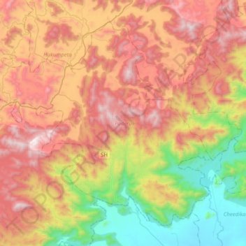
Name: Paderu topographic map, elevation, terrain.
Location: Paderu, Alluri Sitharama Raju, Andhra Pradesh, 531024, India (17.92354 82.54848 18.16836 82.85781)
Average elevation: 816 m
Minimum elevation: 62 m
Maximum elevation: 1,620 m
Other topographic maps
Click on a map to view its topography, its elevation and its terrain.
Vijayawada
Vijayawada lies on the banks of Krishna river, covered by hills and canals. and at an altitude of 11 m (36 ft) above sea level. Three canals originating from the north side of the Prakasam Barrage reservoir — Eluru, Bandar, and Ryves — flow through the city.
Average elevation: 37 m
Kakinada
India > Andhra Pradesh > Kakinada (Urban)
Kakinada is located at 16°56′N 82°13′E / 16.93°N 82.22°E / 16.93; 82.22. The 82-degrees east longitude passes through the city. It has an average elevation of 2 metres (6 ft), and many areas of the city are below sea level.
Average elevation: 7 m
Rajamahendravaram
India > Andhra Pradesh > Rajahmundry (Urban)
Rajahmundry is located at 16°59′N 81°47′E / 16.98°N 81.78°E / 16.98; 81.78. with an average elevation of 14 metres (46 ft). It is geographically located at centre of Godavari Districts. There is paddy, sugarcane and various varieties of flowers cultivation in the area. River Godavari flows…
Average elevation: 29 m
Ongole
India > Andhra Pradesh > Ongole
Ongole is located at 15.5°N 80.05°E. It has an average elevation of 10 m (33 ft) AMSL and is situated on the plains. The city is around 149 kilometres (93 mi) to the south west of Amaravati, the stat capital.
Average elevation: 15 m
Nagalapuram
India > Andhra Pradesh > Nagalapuram
Nagalapuram is located at 13°24′00″N 79°47′00″E / 13.4000°N 79.7833°E / 13.4000; 79.7833. It has an average elevation of 64 meters (213 feet).
Average elevation: 87 m
Kaikaluru
India > Andhra Pradesh > Kaikaluru
Kaikalur is located at 16°34′00″N 81°12′00″E / 16.5667°N 81.2000°E / 16.5667; 81.2000. It has an average elevation of 18 m (59 ft). Sri Syamalamba temple is one of the famous temples there.
Average elevation: 4 m
Pakala
India > Andhra Pradesh > Pakala
Pakala consists of 180 villages and 28 panchayats. Nagamma Agraharam is the smallest village and Pakala is the biggest village. It is in the 371 m elevation (altitude).
Average elevation: 384 m
Tadipatri
India > Andhra Pradesh > Tadpatri
Tadipatri is located at 14°55′N 78°01′E / 14.92°N 78.02°E / 14.92; 78.02. Its average elevation is 223 metres or 731 feet. Tadipatri lies on the southern bank of Pennar River. Due to Mid Pennar Dam constructed upstream, the section of river in Tadipatri is usually dry throughout the year.…
Average elevation: 273 m
Nellore
India > Andhra Pradesh > Nellore
Nellore is located at 14°26′N 79°59′E / 14.44°N 79.98°E / 14.44; 79.98. It has an average elevation of 18 metres (59 ft).
Average elevation: 17 m
Tenali
India > Andhra Pradesh > Tenali
Tenali is situated at 16°14′20″N 80°38′42″E / 16.239°N 80.645°E / 16.239; 80.645, on the southern deltaic region of Krishna River. The city is spread over an area of 29.56 km2 (11.41 sq mi). It lies at an average altitude of 13 metres (43 ft) above mean sea level. It is also called as City…
Average elevation: 12 m