
Botad District topographic map
Interactive map
Click on the map to display elevation.
About this map
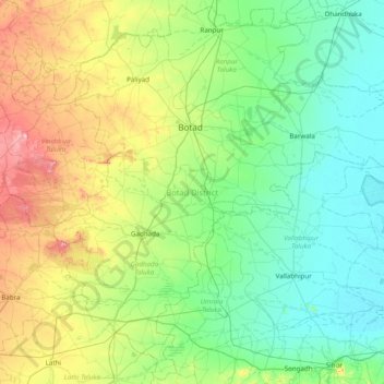
Name: Botad District topographic map, elevation, terrain.
Location: Botad District, Gujarat, India (21.69248 71.39064 22.39813 72.17056)
Average elevation: 82 m
Minimum elevation: 6 m
Maximum elevation: 316 m
Other topographic maps
Click on a map to view its topography, its elevation and its terrain.
Bhuj
India > Gujarat > Bhuj Taluka
Bhuj has an average elevation of 110 metres (360 feet). On the eastern side of the city is a hill known as Bhujia Hill, on which there is a Bhujia Fort, that separates Bhuj city and Madhapar town ( considered one of the richest villages in Asia ). It has two lakes namely Hamirsar and Deshadsar (દેેેશળસર).
Average elevation: 130 m
Adalaj
India > Gujarat > Gandhinagar Taluka
Adalaj is located at 23°10′N 72°35′E / 23.17°N 72.58°E / 23.17; 72.58. It has an average elevation of 66 metres (217 ft). According to the Bureau of Indian Standards, the town falls under seismic zone 3, in a scale of 2 to 5 (in order of increasing vulnerability to earthquakes).
Average elevation: 66 m
Dhrangadhra
India > Gujarat > Dhrangadhra Taluka
Dhrangadhra is located at 22°59′N 71°28′E / 22.98°N 71.47°E / 22.98; 71.47. It has an average elevation of 64 metres (209 feet).
Average elevation: 52 m
Bharuch
India > Gujarat > Bharuch Taluka
Bharuch is located at 21°42′N 72°58′E / 21.7°N 72.97°E / 21.7; 72.97. It has an average elevation of 15 metres (49 feet). Bharuch is a port city situated on the banks of the Narmada river. The damming of the Narmada caused the original port facilities to close, the nearest port is now in…
Average elevation: 15 m
Surat
India > Gujarat > Katargam Taluka > Surat
Surat is a port city situated on the banks of the Tapi river. Damming of the Tapi caused the original port facilities to close; the nearest port is now in the Magadalla and Hazira area of Surat Metropolitan Region.It has famous beach called 'Dumas Beach' located in Hazira. The city is located at 21°10′N…
Average elevation: 11 m
Gandhinagar
India > Gujarat > Gandhinagar Taluka > Gandhinagar
Gandhinagar has an average elevation of 81 metres (266 feet). The city sits on the banks of the Sabarmati River, in north-central-east Gujarat. The 20,543 km2 area around Gandhinagar is defined by Gujarat capital territory. It spans an area of 205 km2 (79 sq mi). The river frequently dries up in the summer,…
Average elevation: 76 m
Kalavad
India > Gujarat > Kalavad Taluka
Kalavad is located at 22°13′N 70°23′E / 22.22°N 70.38°E / 22.22; 70.38. It has an average elevation of 87 metres (285 feet).
Average elevation: 100 m
Palanpur
India > Gujarat > Palanpur Taluka
Palanpur is located at 24°06′N 72°15′E / 24.10°N 72.25°E / 24.10; 72.25. It has an average elevation of 209 metres (685 ft).
Average elevation: 218 m
Rajpipla
India > Gujarat > Nandod Taluka
Rajpipla is located at 21°47′N 73°34′E / 21.78°N 73.57°E / 21.78; 73.57. It has an average elevation of 148 metres (485 feet).
Average elevation: 50 m
Netrang
India > Gujarat > Netrang Taluka
Netrang lies in the southern part of the Gujarat peninsula at an elevation of 435 metres (1,427 ft) and has a tropical savanna climate (under Köppen's Climate classification), moderated by the Arabian Sea. The summer begins in early March and lasts until June. April and May are the hottest months, the average…
Average elevation: 131 m
Bhavnagar
India > Gujarat > Bhavnagar Taluka
Bhavnagar is a coastal city on the eastern coast of Saurashtra, also known as Kathiawar, located at 21°46′N 72°09′E / 21.77°N 72.15°E / 21.77; 72.15. It has an average elevation of 24 metres (78 ft). It occupies an area of 53.3 km2 (20.6 sq mi). The general slope dips towards the northeast at…
Average elevation: 23 m
Porbandar
India > Gujarat > Porbandar Taluka
Porbandar is located at 21°37′48″N 69°36′0″E / 21.63000°N 69.60000°E / 21.63000; 69.60000. It has an average elevation of 1 metre (3 ft).
Average elevation: 18 m
Kheralu
India > Gujarat > Kheralu Taluka
Kheralu is located at 23°53′N 72°37′E / 23.88°N 72.62°E / 23.88; 72.62. It has an average elevation of 149 metres (488 feet). It is the second largest town in its district after Mehsana proper town.
Average elevation: 172 m
Gadhada
India > Gujarat > Gadhada Taluka > Gadhada
Gadhada is located at 21°58′N 71°34′E / 21.97°N 71.57°E / 21.97; 71.57. It has an average elevation of 104 metres (341 feet).
Average elevation: 92 m