
Bihor topographic map
Interactive map
Click on the map to display elevation.
About this map
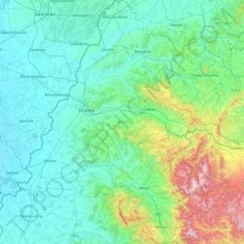
Name: Bihor topographic map, elevation, terrain.
Location: Bihor, Romania (46.38372 21.42762 47.60010 22.81958)
Average elevation: 311 m
Minimum elevation: 84 m
Maximum elevation: 1,831 m
Other topographic maps
Click on a map to view its topography, its elevation and its terrain.
Huta Voivozi
Romania > Bihor > Huta Voivozi
Huta Voivozi, Șinteu, Bihor, 417551, Romania
Average elevation: 589 m
Parcul Salca
Parcul Salca, Dimitrie Cantemir, Oradea, Oradea Metropolitan Area, Bihor, Romania
Average elevation: 133 m