
Takahashi topographic map
Interactive map
Click on the map to display elevation.
Takahashi
Takahashi is located in the midwestern part of Okayama Prefecture, about 32 kilometers northwest of the center of the prefectural capital at Okayama city. The Takahashi River, one of the three major rivers in the prefecture, flows north-south through the eastern side of the city, and the Kibi Plateau spreads east-west on both sides of the river. The municipality measures 35 kilometers from east-to-west and 30 kilometers from north-to-south and the fourth largest municipality in Okayama Prefecture in terms of area. Elevation ranges from 50 to 100 meters in the basin and 300 to 500 meters in the hills. In general, the elevation is higher in the west and lower in the east. The central city area is located in the basin that spreads to the north of the point where the Nariwa River joins the Takahashi River, and retains the old townscape of a castle town. The center of the Nariwa district was also a castle town in the basin along the Nariwa River. In the basin of the Nariwa River, which flows through the western part of the city, the geology is limestone karst topography. In terms of land usage, 78.5% of the total area of the city is classified as forest and wilderness, and 8.7% as cultivated land.
About this map
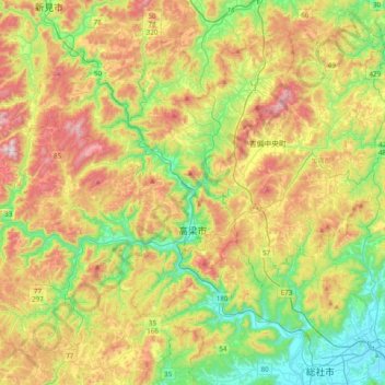
Name: Takahashi topographic map, elevation, terrain.
Location: Takahashi, Okayama Prefecture, Japan (34.68388 133.32886 34.96021 133.72036)
Average elevation: 309 m
Minimum elevation: 4 m
Maximum elevation: 753 m
Other topographic maps
Click on a map to view its topography, its elevation and its terrain.
Mount Yōtei
Japan > Abuta County > Kutchan
In the 50,000:1 scale topographical map of the “Rusutsu” area published in 1920 by Japan’s Land Surveying Department, the mountain is recorded as "Shiribeshi-Yōtei-zan (Ezo-Fuji)". However, since the name was difficult to read, the town of Kutchan asked for it to be changed to Yōtei-zan. The change…
Average elevation: 1,395 m
Kanto
The surface geology of the Kanto Plain is the Quaternary alluvium and diluvium. The low mountain vegetation at an altitude of about 500 to 900 m in and around the plain is an evergreen broad-leaved forest zone. The distribution height range of laurel forests is 900m in Hakone, about 800m in Tanzawa and Takao,…
Average elevation: 265 m
Mt. Hayachine
Mount Hayachine (早池峰山, Hayachine-san) is the highest mountain in the Kitakami Range, located in the Tōhoku region of northern Honshū, Japan. With an elevation of 1,917 m (6,289 ft), it is the second highest in Iwate Prefecture after Mount Iwate. Mount Hayachine is mentioned in 100 Famous Japanese…
Average elevation: 1,490 m
Shiono Cape
Japan > Higashimuro County > Kushimoto
Geologically, the cape is a flat uplifted seafood plateau with an elevation of 60 to 80 meters consisting of two marine terraces, and a coastal cliff with a height of 40 meters. Originally an island, gravel from the estuary of nearby rivers is carried by coastal currents to form a sandbar, which now connects…
Average elevation: 10 m
Mt. Yamato-Katsuragi
Japan > Osaka Prefecture > Minamikawachi County > Chihaya-akasaka
Mount Yamato Katsuragi (大和葛城山, Yamato Katsuragi-san) or simply Mount Katsuragi is a mountain in the Kongō Range straddling the prefectural border between Chihayaakasaka, Osaka and Gose, Nara in Japan. The peak elevation is 959.2 metres (3,147 ft). The mountain is located along the Gose Line of the…
Average elevation: 653 m
Shirakawa
Shirakawa is a mountain village located in far northern Gifu Prefecture, bordering Ishikawa Prefecture and Toyama Prefecture on the Ryōhaku Mountains. Mount Hakusan is the highest elevation at 2,172 metres (7,126 ft). The village's area is 95.7% mountainous forests, and its steep places are characteristic. In…
Average elevation: 667 m