
Peel Region topographic map
Interactive map
Click on the map to display elevation.
Peel Region
The region's climate are influenced by various air masses and weather systems from other locations, proximity to Lake Ontario, topography and elevation (e.g. Niagara Escarpment, and Oak Ridges Moraine), and urban and rural land uses. The air masses and weather systems are the major factors in influencing the climate of the region. Being located in Southern Ontario, it is located between the Arctic, subtropics, and the Atlantic Ocean; consequentially, it is impacted by air masses from different origins. In general, the air masses that affect the region are continental polar, continental arctic, maritime polar, and occasionally continental tropical air masses in summer. During winter, cold and dry air masses predominate (continental arctic and maritime polar) although warmer, moister air masses may move north during this time, leading to milder temperatures and potential for heavy snowfall/freezing rain/rainfall. The most severe snow and freezing rain events occur when warmer, moister air masses move northward to the region and meet colder air. During winter, a common type of storm is known as the "Alberta Clipper" which affects the region in which moist Pacific air moves east of the Rocky Mountains to the region, bringing snow that is often followed by the influx of cold continental air afterwards (leads to colder temperatures). Spring and autumn are characterized by variable weather and rapid alternating air masses. This leads to frequent cloudy conditions, rain, and occasional thunderstorms. In summer, the air masses that influence the region are predominantly maritime polar air masses from the Pacific Ocean, and tropical air masses from the Gulf of Mexico, the latter being responsible for bringing heat waves, high humidity, and intense rainfall events. Towards late summer and early autumn, the remnants of tropical storms and hurricanes may bring strong winds and heavy rainfalls to the area. During autumn, Arctic air masses become increasingly common, leading to colder conditions.
About this map
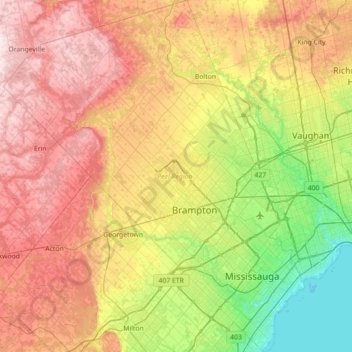
Name: Peel Region topographic map, elevation, terrain.
Location: Peel Region, Golden Horseshoe, Ontario, Canada (43.47899 -80.14426 43.98975 -79.53856)
Average elevation: 265 m
Minimum elevation: 70 m
Maximum elevation: 515 m
Other topographic maps
Click on a map to view its topography, its elevation and its terrain.
Peterborough
Canada > Ontario > Peterborough
Peterborough's topography is largely defined by land formations created by the receding Wisconsian glaciers 10,000–15,000 years ago. The South End and Downtown portions of the City sit on what was the bottom of the glacial Lake Peterborough—part of a glacial spillway created when glacial meltwaters from…
Average elevation: 235 m
Christian Island
Canada > Ontario > Simcoe County
Christian Island is a large island in Georgian Bay close to the communities of Penetanguishene and Midland, Ontario. The island, with its neighbours Hope Island and Beckwith Island, is a 5,428.1 hectares (13,413.1 acres) Ojibwa reserve, known as Christian Island Indian Reserve No. 30. Together with the 7.5…
Average elevation: 185 m
Mindoka
Canada > Ontario > Timiskaming District > Unorganized West Timiskaming
Average elevation: 276 m
Black Bass Island
Canada > Ontario > Parry Sound District > The Archipelago Township
Average elevation: 202 m
Shetland Island
Canada > Ontario > Leeds and Grenville Counties > Leeds and the Thousand Islands
Average elevation: 74 m
Kashabowie
Canada > Ontario > Thunder Bay District > Unorganized Thunder Bay District
Average elevation: 467 m
Alexandria
Canada > Ontario > Stormont, Dundas and Glengarry Counties > North Glengarry
Average elevation: 84 m
Albany Island
Canada > Ontario > Cochrane District > Unorganized North Cochrane
Average elevation: 12 m
Mount Arabella
Canada > Ontario > Sudbury District > Unorganized North Sudbury
Average elevation: 243 m
Quabbin
Canada > Ontario > Leeds and Grenville Counties > Leeds and the Thousand Islands
Average elevation: 97 m
Ludgate
Canada > Ontario > Parry Sound District > Unorganized Centre Parry Sound
Average elevation: 194 m
Beausoleil Island
Canada > Ontario > Muskoka District > Georgian Bay Township
Average elevation: 180 m
Toronto
Despite its deep ravines, Toronto is not remarkably hilly, but its elevation does increase steadily away from the lake. Elevation differences range from 76.5 metres (251 ft) above sea level at the Lake Ontario shore to 209 m (686 ft) ASL near the York University grounds in the city's north end at the…
Average elevation: 113 m
Mountain Peak
Canada > Ontario > Timiskaming District > Unorganized West Timiskaming
Average elevation: 255 m
Dalkeith
Canada > Ontario > Stormont, Dundas and Glengarry Counties > North Glengarry
Average elevation: 70 m
Ferris Provincial Park
Canada > Ontario > Northumberland County > Trent Hills > Campbellford
Average elevation: 151 m
Moose Creek
Canada > Ontario > Stormont, Dundas and Glengarry Counties > North Stormont
Average elevation: 87 m
McLaren Island
Canada > Ontario > Stormont, Dundas and Glengarry Counties > South Stormont > Ingleside
Average elevation: 74 m
Private Thomas Millar Armstrong Park
Canada > Ontario > York Region > Richmond Hill
Average elevation: 202 m
Stoney Creek
Canada > Ontario > Thunder Bay District > Unorganized Thunder Bay District
Average elevation: 367 m
Ombabika River
Canada > Ontario > Thunder Bay District > Unorganized Thunder Bay District
Average elevation: 311 m
Tayside
Canada > Ontario > Stormont, Dundas and Glengarry Counties > North Stormont
Average elevation: 85 m