
Scotland topographic map
Interactive map
Click on the map to display elevation.
About this map
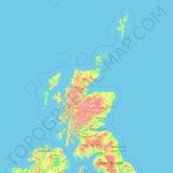
Name: Scotland topographic map, elevation, terrain.
Location: Scotland, United Kingdom (54.43398 -14.01552 61.06100 -0.32092)
Average elevation: 36 m
Minimum elevation: 0 m
Maximum elevation: 1,259 m
A significant exception to the above are the fossil-bearing beds of Old Red Sandstones found principally along the Moray Firth coast. The Highlands are generally mountainous and the highest elevations in the British Isles are found here. Scotland has over 790 islands divided into four main groups: Shetland, Orkney, and the Inner Hebrides and Outer Hebrides. There are numerous bodies of freshwater including Loch Lomond and Loch Ness. Some parts of the coastline consist of machair, a low-lying dune pasture land.
Other topographic maps
Click on a map to view its topography, its elevation and its terrain.
London
United Kingdom > England > London
London, Greater London, England, SW1A 2DX, United Kingdom
Average elevation: 42 m
Bristol
United Kingdom > England > City of Bristol
Bristol, City of Bristol, West of England, England, United Kingdom
Average elevation: 55 m
London
London, Greater London, England, United Kingdom
Average elevation: 66 m
Derby
United Kingdom > England > Derbyshire
Derby, Derbyshire, England, DE1 2AA, United Kingdom
Average elevation: 96 m
North York Moors National Park
United Kingdom > England > North Yorkshire
North York Moors National Park, North Yorkshire, Tees Valley, England, United Kingdom
Average elevation: 110 m
Carlisle
United Kingdom > England > Cumberland
Carlisle, Cumberland, England, United Kingdom
Average elevation: 31 m
Sheffield
Sheffield, South Yorkshire, England, United Kingdom
Average elevation: 168 m
Cambrian Mountains
United Kingdom > Wales > Powys
Cambrian Mountains, Powys, Wales, SY18 6JR, United Kingdom
Average elevation: 319 m
Canterbury
United Kingdom > England > Kent
Canterbury, Kent, England, United Kingdom
Average elevation: 51 m
Nottingham
United Kingdom > England > Nottinghamshire
Nottingham, England, United Kingdom
Average elevation: 56 m
Edinburgh
United Kingdom > Scotland > Edinburgh
Edinburgh, City of Edinburgh, Scotland, EH1 3EG, United Kingdom
Average elevation: 104 m
Leeds
United Kingdom > England > Leeds
Leeds, Yorkshire and the Humber, England, LS1 6AL, United Kingdom
Average elevation: 94 m
East of England
East of England, England, United Kingdom
Average elevation: 39 m
South East England
South East England, England, United Kingdom
Average elevation: 69 m
Lincolnshire
Lincolnshire, East Midlands, England, United Kingdom
Average elevation: 28 m
City of London
United Kingdom > England > City of London > City of London
City of London, England, EC2V 5AE, United Kingdom
Average elevation: 42 m
Greater Manchester
Greater Manchester, England, United Kingdom
Average elevation: 141 m
Oxford
United Kingdom > England > Oxfordshire
Oxford, Oxfordshire, England, United Kingdom
Average elevation: 81 m
Lancaster
United Kingdom > England > Lancashire
Lancaster, Lancashire, England, United Kingdom
Average elevation: 84 m
Norwich
United Kingdom > England > Norfolk
Norwich, Norfolk, England, United Kingdom
Average elevation: 28 m
Liverpool
Liverpool, Liverpool City Region, England, United Kingdom
Average elevation: 26 m
Leicester
United Kingdom > England > Leicestershire
Leicester, Leicestershire, England, LE1 5YA, United Kingdom
Average elevation: 109 m
Glasgow
United Kingdom > Scotland > Glasgow City
Glasgow, Glasgow City, Scotland, G2 1DY, United Kingdom
Average elevation: 128 m
Dundee
United Kingdom > Scotland > Dundee City
Dundee, Dundee City, Scotland, DD1 1SG, United Kingdom
Average elevation: 82 m
Shane's Castle Park
United Kingdom > Northern Ireland > County Antrim > Randalstown
Shane's Castle Park, Randalstown, County Antrim, Northern Ireland, United Kingdom
Average elevation: 30 m
River Severn
United Kingdom > Wales > Powys > Welshpool
River Severn, Bronybuckley, Welshpool, Powys, Wales, SY21 7BA, United Kingdom
Average elevation: 92 m
Castleton
United Kingdom > England > Derbyshire > High Peak
Castleton, High Peak, Derbyshire, England, United Kingdom
Average elevation: 326 m
Snowdon
United Kingdom > Wales > Gwynedd
Snowdon, Gwynedd, Wales, LL55 4UL, United Kingdom
Average elevation: 692 m
Shropshire
Shropshire, West Midlands, England, United Kingdom
Average elevation: 166 m
Lake District National Park
Lake District National Park, England, United Kingdom
Average elevation: 206 m
Chiltern District
United Kingdom > England > Buckinghamshire > Chalfont St Peter
Chiltern District, Chalfont St Peter, Buckinghamshire, England, United Kingdom
Average elevation: 137 m
Aberdeenshire
Aberdeenshire, Scotland, United Kingdom
Average elevation: 199 m
Gillingham
United Kingdom > England > Kent
Gillingham, Kent, England, ME7 5FA, United Kingdom
Average elevation: 40 m
Kingwood Common
United Kingdom > England > Oxfordshire > South Oxfordshire > Highmoor
Kingwood Common, Highmoor, South Oxfordshire, Oxfordshire, England, United Kingdom
Average elevation: 125 m
Grassholme
United Kingdom > England > County Durham
Grassholme, Grassholme Farm, Lunedale, County Durham, North East, England, DL12 0PR, United Kingdom
Average elevation: 335 m
Northamptonshire
Northamptonshire, England, United Kingdom
Average elevation: 97 m
Gloucestershire
Gloucestershire, England, United Kingdom
Average elevation: 99 m
Wirral
Wirral, Liverpool City Region, England, United Kingdom
Average elevation: 21 m
Dorset
United Kingdom > England > Talbot Village
Dorset, Alder Road, Branksome, Talbot Village, Bournemouth, Christchurch and Poole, South West England, England, BH12 5BJ, United Kingdom
Average elevation: 57 m