
Make a donation
Gear up for your next adventure:
As an Amazon Associate, this site earns from qualifying purchases at no extra cost to you.
Vayots Dzor Province topographic map
Click on the map to display elevation.
Gear up for your next adventure:
As an Amazon Associate, this site earns from qualifying purchases at no extra cost to you.
Vayots Dzor Province
Vayots Dzor is among the leading provinces of Armenia in wine production in terms of grape cultivation and wine export (along with the provinces of Ararat and Armavir). Internationally renowned winemaker Paul Hobbs and the Yacoubian family journey to the Birthplace of Wine to craft modern, world-class wines from the indigenous varieties found in the high-altitude, mineral-rich soils of Vayots Dzor. Among the Yacoubian-Hobbs portfolio are a Dry White Wine predominantly made of Voskehat, and two different Areni. Their vineyards grow a stone's throw away from the Areni-1 cave, the oldest known winery dating from over 6000 years ago. With their local team, Paul and the Yacoubians are growing and crafting wines that confirm Armenia's part, not only in the ancient history of winemaking, but in its very relevant present and future amongst the great wine regions of the world.
Make a donation
Gear up for your next adventure:
As an Amazon Associate, this site earns from qualifying purchases at no extra cost to you.
About this map
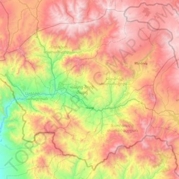
Name: Vayots Dzor Province topographic map, elevation, terrain.
Location: Vayots Dzor Province, Armenia (39.49046 45.06005 40.01218 45.81453)
Average elevation: 2,155 m
Minimum elevation: 886 m
Maximum elevation: 3,503 m
Make a donation
Gear up for your next adventure:
As an Amazon Associate, this site earns from qualifying purchases at no extra cost to you.
Other topographic maps
Click on a map to view its topography, its elevation and its terrain.
Make a donation
Gear up for your next adventure:
As an Amazon Associate, this site earns from qualifying purchases at no extra cost to you.
Make a donation
Gear up for your next adventure:
As an Amazon Associate, this site earns from qualifying purchases at no extra cost to you.
Vardenis
Armenia > Gegharkunik Province
Located in the valley of the Masrik River at an elevation of 2006 meters above sea level, Vardenis is dominated by the 82-kilometre (51 mi) range of Vardenis Mountains. The highest peak of the range is Mount Vardenis at 3,522 metres (11,555 ft) above sea level, located around 23 km southwest of Vardenis town.…
Average elevation: 1,949 m
Make a donation
Gear up for your next adventure:
As an Amazon Associate, this site earns from qualifying purchases at no extra cost to you.
Make a donation
Gear up for your next adventure:
As an Amazon Associate, this site earns from qualifying purchases at no extra cost to you.
Make a donation
Gear up for your next adventure:
As an Amazon Associate, this site earns from qualifying purchases at no extra cost to you.
Make a donation
Gear up for your next adventure:
As an Amazon Associate, this site earns from qualifying purchases at no extra cost to you.
Make a donation
Gear up for your next adventure:
As an Amazon Associate, this site earns from qualifying purchases at no extra cost to you.
Make a donation
Gear up for your next adventure:
As an Amazon Associate, this site earns from qualifying purchases at no extra cost to you.
Aragats
Mount Aragats has a topographic prominence of 2,143 meters, more than some higher mountains, such as Dykh-Tau (5,205 m high) in the Russian part of Great Caucasus Range.
Average elevation: 3,645 m
Aparan
Modern-day Aparan is located at the eastern slopes of Mount Aragats and the northern slopes of Mount Ara, on the shores of Kasagh River, with an elevation of 1880 metres above sea level. The town is located at a road distance of 42 km north of Yerevan and 32 km north of the provincial capital Ashtarak, on the…
Average elevation: 1,939 m
Kapan
The town is about 80 km (50 mi) north of the Iranian border. With a height of 3201 meters, Mount Khustup is the highest peak of the region. The elevation of Kapan is 750–1050 meters above sea level, with an average height of 910 meters. Two tributaries of the Voghji River, Vachagan and Kavart, flow through…
Average elevation: 1,110 m
Make a donation
Gear up for your next adventure:
As an Amazon Associate, this site earns from qualifying purchases at no extra cost to you.
Make a donation
Gear up for your next adventure:
As an Amazon Associate, this site earns from qualifying purchases at no extra cost to you.
Gyumri
Gyumri is 126 kilometres (78 miles) north of the capital Yerevan at the central part of the Shirak plateau. It has an approximate height of 1,550 metres (5,090 feet) above sea level, the high altitude line being 1,500 metres (4,900 feet). The Akhurian River passes through the western suburbs. The Shirak…
Average elevation: 1,547 m
Halidzor
Geographically, Halidzor is located near the left bank of the Vorotan River, at an altitude of 1300-1350 m above sea level. The regional center of Syunik province - the city of Kapan, is 62 km away. The nearest town is Goris, which is 12 km to the southwest.
Average elevation: 1,326 m
Make a donation
Gear up for your next adventure:
As an Amazon Associate, this site earns from qualifying purchases at no extra cost to you.
Make a donation
Gear up for your next adventure:
As an Amazon Associate, this site earns from qualifying purchases at no extra cost to you.
Make a donation
Gear up for your next adventure:
As an Amazon Associate, this site earns from qualifying purchases at no extra cost to you.
Aparan
Modern-day Aparan is located at the eastern slopes of Mount Aragats and the northern slopes of Mount Ara, on the shores of Kasagh River, with an elevation of 1880 metres above sea level. The town is located at a road distance of 42 km north of Yerevan and 32 km north of the provincial capital Ashtarak, on the…
Average elevation: 1,939 m
Make a donation
Gear up for your next adventure:
As an Amazon Associate, this site earns from qualifying purchases at no extra cost to you.
Make a donation
Gear up for your next adventure:
As an Amazon Associate, this site earns from qualifying purchases at no extra cost to you.
Make a donation
Gear up for your next adventure:
As an Amazon Associate, this site earns from qualifying purchases at no extra cost to you.
Gyumri
Armenia > Shirak Province > Gyumri
Gyumri is 126 kilometres (78 miles) north of the capital Yerevan at the central part of the Shirak plateau. It has an approximate height of 1,550 metres (5,090 feet) above sea level, the high altitude line being 1,500 metres (4,900 feet). The Akhurian River passes through the western suburbs. The Shirak…
Average elevation: 1,535 m
Make a donation
Gear up for your next adventure:
As an Amazon Associate, this site earns from qualifying purchases at no extra cost to you.
Make a donation
Gear up for your next adventure:
As an Amazon Associate, this site earns from qualifying purchases at no extra cost to you.