East Godavari topographic map
Interactive map
Click on the map to display elevation.
About this map
![East Godavari topographic map, elevation, terrain](/pub/maps/relation/z3tj/cwbm3q/thumbnail.jpg)
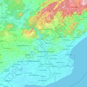
Name: East Godavari topographic map, elevation, terrain.
Location: East Godavari, Andhra Pradesh, India (16.67846 81.29282 17.31826 82.07778)
Average elevation: 60 m
Minimum elevation: -2 m
Maximum elevation: 655 m
East Godavari occupies an area of 12,805 square kilometres (4,944 sq mi), comparatively equivalent to Indonesia's Sumba Island. The district is bounded on north by Visakhapatnam district, Malkangiri district of Orissa on the northwest by Khammam district and Sukma district of Chhattisgarh, on the east and south by the Bay of Bengal and on the west by West Godavari. It has a coastline of 144 km (89 mi). The small enclave (30 km2 or 12 sq mi) of the Yanam district of Puducherry state lies within this district. The topography consists of hills in the north west and fertile plains in the central part and towards the east. The plains are drained by Godavari river and its landscape is filled with evergreen paddy fields all along the delta. It is the largest producer of Paddy in whole of Andhra Pradesh. Papikondalu part of Eastern Ghats is the hilly terrain in located the north western part of this district, it consists of hills running on both the sides of river Godavari until Bhadrachalam, Telangana. The temperature remains humid for most of the months as it is located in the coastal belt. This district is referred as the green belt of Andhra due to its greenery spread all around. There are abundant deciduous forests in the Northwest part near Maredumilli and to the east near Kakinada there are mangrove forests.
Other topographic maps
Click on a map to view its topography, its elevation and its terrain.
![Vadapalem topographic map, elevation, terrain](/pub/maps/node/98b3/f3qm7sgt/icon.jpg)
Vadapalem
India > Andhra Pradesh > Visakhapatnam (Rural)
Vadapalem, Visakhapatnam (Rural), Visakhapatnam, Andhra Pradesh, 530045, India
Average elevation: 29 m
![Chagallu topographic map, elevation, terrain](/pub/maps/relation/7rkl/bkpz9m/icon.jpg)
Chagallu
Chagallu, East Godavari, Andhra Pradesh, 534342, India
Average elevation: 32 m
![Madanapalle topographic map, elevation, terrain](/pub/maps/relation/l1tp/9kjngt/icon.jpg)
Madanapalle
Madanapalle, Annamayya District, Andhra Pradesh, India
Average elevation: 777 m
![Vijayawada topographic map, elevation, terrain](/pub/maps/node/hqgp/67vnl8kl/icon.jpg)
Vijayawada
India > Andhra Pradesh > Vijayawada (Urban)
Vijayawada, Vijayawada (Urban), NTR District, Andhra Pradesh, 520001, India
Average elevation: 36 m
![Babanagar topographic map, elevation, terrain](/pub/maps/node/kl4s/dkxr68gp/icon.jpg)
Babanagar
India > Andhra Pradesh > Gospadu
Babanagar, Gospadu, Nandyal District, Andhra Pradesh, 518593, India
Average elevation: 210 m
![Maredumilli topographic map, elevation, terrain](/pub/maps/relation/lrmt/3p6q3q/icon.jpg)
Maredumilli
Maredumilli, Alluri Sitharama Raju District, Andhra Pradesh, 533295, India
Average elevation: 497 m
![Srikakulam topographic map, elevation, terrain](/pub/maps/relation/fmt/3ph33q/icon.jpg)
Srikakulam
Srikakulam, Srikakulam District, Andhra Pradesh, India
Average elevation: 20 m
![Regidi Amadalavalasa topographic map, elevation, terrain](/pub/maps/node/4x1h/flbmw4mt/icon.jpg)
Regidi Amadalavalasa
India > Andhra Pradesh > Regidi Amadalavalasa
Regidi Amadalavalasa, Vizianagaram, Andhra Pradesh, India
Average elevation: 58 m
![Building topographic map, elevation, terrain](/pub/maps/node/fvgt/73bplkcz/icon.jpg)
Building
India > Andhra Pradesh > Penamaluru > Tadigadapa
Building, Tadigadapa, Penamaluru, Krishna, Andhra Pradesh, 521137, India
Average elevation: 18 m
![Dr. B. R. Ambedkar Konaseema topographic map, elevation, terrain](/pub/maps/relation/67mt/vhlb3l/icon.jpg)
Dr. B. R. Ambedkar Konaseema
Dr. B. R. Ambedkar Konaseema, Andhra Pradesh, India
Average elevation: 5 m
![Velur topographic map, elevation, terrain](/pub/maps/node/3krr/flp993gt/icon.jpg)
Velur
India > Andhra Pradesh > Pichatur
Velur, Pichatur, Tirupati, Andhra Pradesh, 517587, India
Average elevation: 73 m
![Kotturu topographic map, elevation, terrain](/pub/maps/node/kczs/7fx6dx14/icon.jpg)
Kotturu
India > Andhra Pradesh > Kaviti
Kotturu, Kaviti, Srikakulam, Andhra Pradesh, 532322, India
Average elevation: 43 m
![Mahabubnagar topographic map, elevation, terrain](/pub/maps/node/fb14/d2g7m1gp/icon.jpg)
Mahabubnagar
India > Andhra Pradesh > Chakrayapet > Kuppaguttapalle
Mahabubnagar, Kuppaguttapalle, Chakrayapet, YSR, Andhra Pradesh, 516259, India
Average elevation: 341 m
![Kakinada topographic map, elevation, terrain](/pub/maps/node/sq51/845dncdn/icon.jpg)
Kakinada
India > Andhra Pradesh > Kakinada (Urban)
Kakinada, Kakinada (Urban), Kakinada, Andhra Pradesh, 533001, India
Average elevation: 7 m
![Peddapalli topographic map, elevation, terrain](/pub/maps/node/p1dn/jrnb94t6/icon.jpg)
Peddapalli
India > Andhra Pradesh > Galiveedu
Peddapalli, Galiveedu, Annamayya, Andhra Pradesh, India
Average elevation: 377 m
![Pangili topographic map, elevation, terrain](/pub/maps/node/69s8/w2j3v54s/icon.jpg)
Pangili
India > Andhra Pradesh > Rapur
Pangili, Rapur, Sri Potti Sriramulu Nellore, Andhra Pradesh, 524408, India
Average elevation: 96 m
![Tadipatri topographic map, elevation, terrain](/pub/maps/node/6wmt/5k9rgvnx/icon.jpg)
Tadipatri
India > Andhra Pradesh > Tadpatri
Tadipatri, Tadpatri, Anantapur, Andhra Pradesh, 515400, India
Average elevation: 273 m
![Papireddipalle topographic map, elevation, terrain](/pub/maps/node/qcz/bph3nvt6/icon.jpg)
Papireddipalle
India > Andhra Pradesh > Veligandla
Papireddipalle, Veligandla, Prakasam, Andhra Pradesh, 523224, India
Average elevation: 130 m
![Kadidaddi topographic map, elevation, terrain](/pub/maps/node/pnm2/k718m19m/icon.jpg)
Kadidaddi
India > Andhra Pradesh > Kosigi
Kadidaddi, Kosigi, Kurnool, Andhra Pradesh, India
Average elevation: 342 m
![Munimadugu topographic map, elevation, terrain](/pub/maps/node/r5k/tz5dqqtj/icon.jpg)
Munimadugu
India > Andhra Pradesh > Penukonda
Munimadugu, Penukonda, Sri Sathya Sai, Andhra Pradesh, 515164, India
Average elevation: 488 m
![Proddatur topographic map, elevation, terrain](/pub/maps/node/dtdn/6lnvh3s8/icon.jpg)
Proddatur
India > Andhra Pradesh > Proddatur
Proddatur, YSR, Andhra Pradesh, 516360, India
Average elevation: 168 m
![Ainavilli topographic map, elevation, terrain](/pub/maps/relation/wtnx/2j8vt6/icon.jpg)
Ainavilli
Ainavilli, Dr. B. R. Ambedkar Konaseema, Andhra Pradesh, 533228, India
Average elevation: 7 m
![Jangalapalle topographic map, elevation, terrain](/pub/maps/node/f2z4/m1bcvgrr/icon.jpg)
Jangalapalle
India > Andhra Pradesh > Anantapur
Jangalapalle, Anantapur, Andhra Pradesh, 515721, India
Average elevation: 372 m
![Nellore topographic map, elevation, terrain](/pub/maps/node/n5m2/mqtcfm1h/icon.jpg)
Nellore
India > Andhra Pradesh > Nellore
Nellore, Sri Potti Sriramulu Nellore, Andhra Pradesh, 524001, India
Average elevation: 17 m
![Mamidipalli topographic map, elevation, terrain](/pub/maps/node/wx4s/rqvr9snx/icon.jpg)
Mamidipalli
India > Andhra Pradesh > Vajrapukothuru
Mamidipalli, Vajrapukothuru, Srikakulam, Andhra Pradesh, 532219, India
Average elevation: 78 m
![Vinjamur topographic map, elevation, terrain](/pub/maps/relation/dj4s/gwszz4/icon.jpg)
Vinjamur
Vinjamur, Sri Potti Sriramulu Nellore, Andhra Pradesh, 524228, India
Average elevation: 93 m
![Nallamala Forest topographic map, elevation, terrain](/pub/maps/relation/gctf/lndmtp/icon.jpg)
Nallamala Forest
Nallamala Forest, Andhra Pradesh, India
Average elevation: 278 m
![Kantamavaripalle topographic map, elevation, terrain](/pub/maps/node/kbf3/x7dg47b3/icon.jpg)
Kantamavaripalle
India > Andhra Pradesh > Kanigiri
Kantamavaripalle, Kanigiri, Prakasam, Andhra Pradesh, India
Average elevation: 88 m
![Ganapathi Nagar topographic map, elevation, terrain](/pub/maps/node/wtb3/q7pz1bnx/icon.jpg)
Ganapathi Nagar
India > Andhra Pradesh > Sabbavaram
Ganapathi Nagar, Sabbavaram, Anakapalli, Andhra Pradesh, 531035, India
Average elevation: 55 m
![Indupur topographic map, elevation, terrain](/pub/maps/node/j857/l8fvw5dn/icon.jpg)
Indupur
India > Andhra Pradesh > Allur
Indupur, Allur, Sri Potti Sriramulu Nellore, Andhra Pradesh, 524315, India
Average elevation: 7 m
![Mandli topographic map, elevation, terrain](/pub/maps/node/h5gt/ksmpqq9m/icon.jpg)
Mandli
India > Andhra Pradesh > Somandepalle
Mandli, Somandepalle, Sri Sathya Sai, Andhra Pradesh, India
Average elevation: 608 m
![Timmapuram topographic map, elevation, terrain](/pub/maps/node/749m/wkn659zs/icon.jpg)
Timmapuram
India > Andhra Pradesh > Bheemunipatnam
Timmapuram, Bheemunipatnam, Visakhapatnam, Andhra Pradesh, 530045, India
Average elevation: 40 m
![Kadapa topographic map, elevation, terrain](/pub/maps/node/6f4s/ll2d659m/icon.jpg)
Kadapa
India > Andhra Pradesh > Kadapa
Kadapa, YSR, Andhra Pradesh, 516001, India
Average elevation: 257 m
![Sunki topographic map, elevation, terrain](/pub/maps/node/sm2/66mnxb1h/icon.jpg)
Sunki
India > Andhra Pradesh > Garugubilli
Sunki, Garugubilli, Parvathipuram Manyam, Andhra Pradesh, 532531, India
Average elevation: 101 m
![Agaram topographic map, elevation, terrain](/pub/maps/node/xq9m/gwfzzk3l/icon.jpg)
Agaram
India > Andhra Pradesh > Nindra
Agaram, Nindra, Chittoor, Andhra Pradesh, 517591, India
Average elevation: 80 m
![Puram topographic map, elevation, terrain](/pub/maps/node/j757/x9ghv7f3/icon.jpg)
Puram
India > Andhra Pradesh > Yerpedu > Sadasivapuram
Puram, Sadasivapuram, Yerpedu, Tirupati, Andhra Pradesh, India
Average elevation: 93 m
![K Nagarapalem topographic map, elevation, terrain](/pub/maps/node/xns8/k3gtwlzs/icon.jpg)
K Nagarapalem
India > Andhra Pradesh > Bheemunipatnam
K Nagarapalem, Bheemunipatnam, Visakhapatnam, Andhra Pradesh, 530048, India
Average elevation: 42 m
![Hukumpeta topographic map, elevation, terrain](/pub/maps/node/83rr/fmzzjcgt/icon.jpg)
Hukumpeta
India > Andhra Pradesh > Rajahmundry Rural
Hukumpeta, Rajahmundry Rural, East Godavari District, Andhra Pradesh, 533103, India
Average elevation: 28 m
![Vinukonda topographic map, elevation, terrain](/pub/maps/relation/h1gt/jw2nb3/icon.jpg)
Vinukonda
Vinukonda, Palnadu District, Andhra Pradesh, India
Average elevation: 110 m
![Satram topographic map, elevation, terrain](/pub/maps/node/dzmt/gzbvnf3l/icon.jpg)
Satram
India > Andhra Pradesh > Gajuwaka
Satram, Gajuwaka, Visakhapatnam District, Andhra Pradesh, 530053, India
Average elevation: 52 m
![Madanapalle topographic map, elevation, terrain](/pub/maps/node/mtgt/wkmkjs4s/icon.jpg)
Madanapalle
India > Andhra Pradesh > Punganur
Madanapalle, Punganur, Chittoor District, Andhra Pradesh, 517247, India
Average elevation: 743 m
![Savamgudem topographic map, elevation, terrain](/pub/maps/node/f3s8/64zslg9m/icon.jpg)
Savamgudem
India > Andhra Pradesh > Gannavaram
Savamgudem, Gannavaram, Krishna District, Andhra Pradesh, 521107, India
Average elevation: 19 m