
Sublette County topographic map
Interactive map
Click on the map to display elevation.
About this map
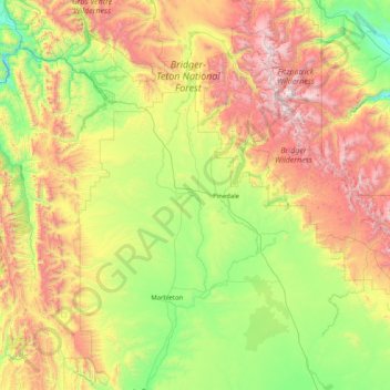
Name: Sublette County topographic map, elevation, terrain.
Location: Sublette County, Wyoming, United States (42.26328 -110.62381 43.46494 -109.04309)
Average elevation: 2,520 m
Minimum elevation: 1,775 m
Maximum elevation: 4,090 m
Other topographic maps
Click on a map to view its topography, its elevation and its terrain.
Grand Teton National Park
United States > Wyoming > Teton County
Grand Teton National Park is named for Grand Teton, the tallest mountain in the Teton Range. The naming of the mountains is attributed to early 19th-century French-speaking trappers—les trois tétons (the three teats) was later anglicized and shortened to Tetons. At 13,775 feet (4,199 m), Grand Teton…
Average elevation: 2,409 m
Rocky Mountains
United States > Wyoming > Teton County
Agriculture and forestry are major industries. Agriculture includes dryland and irrigated farming and livestock grazing. Livestock are frequently moved between high-elevation summer pastures and low-elevation winter pastures, a practice known as transhumance.
Average elevation: 2,292 m
Curt Gowdy State Park
United States > Wyoming > Laramie County
Park terrain consists of rolling hills and sharp granite outcroppings in the foothills of the Laramie Mountains. Elevation ranges from 6,450 feet (1,970 m) to over 7,500 feet (2,290 m). Wildlife that can be found include: kokanee salmon, perch, brown, rainbow and lake trout, white-tailed deer, and mule deer.…
Average elevation: 2,271 m
Gannett Peak
United States > Wyoming > Fremont County
Gannett Peak is the highest mountain peak in the U.S. state of Wyoming at 13,810 feet (4,210 m). It lies in the Wind River Range within the Bridger Wilderness of the Bridger-Teton National Forest. Straddling the Continental Divide along the boundary between Fremont and Sublette counties, it has the second…
Average elevation: 3,700 m
Dubois
United States > Wyoming > Fremont County
Dubois is located at 43°32′9″N 109°38′9″W / 43.53583°N 109.63583°W / 43.53583; -109.63583 (43.535936, -109.635915) and an elevation of 2115 m (6940 ft). The Wind River runs through the town.
Average elevation: 2,167 m
Yellowstone National Park
Yellowstone National Park spans an area of 3,468.4 sq mi (8,983 km2), comprising lakes, canyons, rivers, and mountain ranges. Yellowstone Lake is one of the largest high-elevation lakes in North America and is centered over the Yellowstone Caldera, the largest supervolcano on the continent. The caldera is…
Average elevation: 2,450 m
Laramie
United States > Wyoming > Albany County
Laramie (/ˈlærəmi/) is a city in and the county seat of Albany County, Wyoming, United States, known for its high elevation at 7,200 feet (2,200 m), railroad history, and as the higher-education center for the state of Wyoming. The population was estimated 31,407 in 2020, making it the 4th most populous…
Average elevation: 2,219 m
World's Largest Mineral Hot Spring
United States > Wyoming > Hot Springs County > Thermopolis
Average elevation: 1,360 m
Jackson
United States > Wyoming > Teton County
Jackson is located at 43°28′31″N 110°46′9″W / 43.47528°N 110.76917°W / 43.47528; -110.76917 (43.475, −110.769), at an elevation of 6,237 feet (1,901 m) above sea level. According to the United States Census Bureau, the town has a total area of 2.95 square miles (7.64 km2), of which 2.91…
Average elevation: 2,043 m
Worland
United States > Wyoming > Washakie County
Due to the location within the Big Horn Basin, it is protected from severe weather by the surrounding mountains from nearly every direction. This topography results in weather that is highly continental with frigid and dry winters, little wind, little rainfall and few storms. Worland is the least windy…
Average elevation: 1,268 m
Cloud Peak
United States > Wyoming > Big Horn County
It rises to an elevation of 13,171 feet (4,015 m) and provides onlookers with dramatic views and vistas. The mountain can be climbed most easily from the western side, accessed by either the Battle Park or West Tensleep trail-heads and is roughly 24 miles round-trip from both. The peak is located in the…
Average elevation: 3,598 m
Cody
United States > Wyoming > Park County
Cody's elevation is approximately 4,997 feet (1,523 m) above sea level. The main part of the city is split across three levels, separated by about 60 feet (18 m).
Average elevation: 1,557 m
Cheyenne
United States > Wyoming > Laramie County
The Cheyenne Regional Airport was opened in 1920, initially serving as a stop for airmail. It soon developed into a civil-military airport, serving DC-3s and various military craft. During World War II, hundreds of B-17s, B-24s, and PBYs were outfitted and upgraded at the airfield. Today, it serves a number of…
Average elevation: 1,871 m
Laramie
United States > Wyoming > Albany County > Laramie
Laramie is on a high plain between two mountain ranges, the Snowy Range, about 30 miles (48 km) to the west, and the Laramie Range, 7 miles (11 km) to the east. The city's elevation above sea level is approximately 7,165 feet (2,184 m). The Laramie River runs through Laramie toward its confluence with the…
Average elevation: 2,299 m
Thayne
United States > Wyoming > Lincoln County > Thayne
Thayne is located at 42°55′11″N 111°0′3″W / 42.91972°N 111.00083°W / 42.91972; -111.00083 (42.919754, -111.000714), at 5906 feet in elevation. It sits in the northern portion of Wyoming's grassy Star Valley, close to the Salt River. Thayne is surrounded by green grassland and ranches, with…
Average elevation: 1,814 m
Casper Mountain
United States > Wyoming > Natrona County
Casper Mountain, an anticline, is located at the north end of the Laramie Mountains overlooking Casper, Wyoming along the North Platte River. At a top elevation of 8,130 feet (2,478 m), the geological feature rises approximately 3,000 feet (914 m) above Casper.
Average elevation: 2,315 m
Worland
United States > Wyoming > Washakie County > Worland
Worland experiences an arid climate (Köppen BWk), but one which is quite distinct from much of the state. Due to the location within the Big Horn Basin, it is protected from severe weather by the surrounding mountains from nearly every direction. This topography results in weather that is highly continental…
Average elevation: 1,319 m
Upper Geyser Basin
United States > Wyoming > Teton County > Upper Geyser Basin
Average elevation: 2,295 m
Pinedale
United States > Wyoming > Sublette County
Pinedale is located at 42°51′58″N 109°51′53″W / 42.86611°N 109.86472°W / 42.86611; -109.86472 (42.866162, −109.864622)[8] and sits at an elevation of 7,175 feet above sea level. According to the United States Census Bureau, the town has a total area of 2.15 square miles (5.57 km2), all land.[9]
Average elevation: 2,196 m
Ranchettes
United States > Wyoming > Laramie County > Cheyenne > Ranchettes
Average elevation: 1,869 m
Yellowstone Lake
United States > Wyoming > Teton County
The lake has been known by various names as depicted on early maps and in journals. Both fur trader David Thompson and explorer William Clark referred to the lake as Yellow Stone. Osborne Russell referred to the lake as Yellow Stone Lake in his 1834 journal. On some William Clark maps, the lake has the name…
Average elevation: 2,453 m
Fremont County
According to the U.S. Census Bureau, the county has a total area of 9,266 square miles (24,000 km2), of which 9,184 square miles (23,790 km2) is land and 82 square miles (210 km2) (0.9%) is water. It is the second-largest county by area in Wyoming, as well as in the six Rocky Mountain States. Elevations and…
Average elevation: 2,108 m
Pinedale
United States > Wyoming > Sublette County
Pinedale is located at 42°51′58″N 109°51′53″W / 42.86611°N 109.86472°W / 42.86611; -109.86472 (42.866162, −109.864622) and sits at an elevation of 7,175 feet above sea level. According to the United States Census Bureau, the town has a total area of 2.15 square miles (5.57 km2), all of it land.
Average elevation: 2,199 m