Geolocate

Derna topographic map

Click on the map to display elevation.

Derna

Libya has mostly a flat undulating plain and occasional plateau, with an average elevation of around 423 m (1,388 ft). Around 91 per cent of the land is covered by desert, with only 8.8 per cent agricultural land (with only 1% arable lands) and 0.1 per cent of forests. The major resources are petroleum, gypsum and natural gas. Along the coastal regions, the climate is Mediterranean in coastal areas, while it is desert climate in all other parts. Dust storms lasting four to eight days is pretty common during Spring. Tripolitania is the northwest region, while it is Cyrenaica in the east and Fezzen in southwest. Cyrenacia is the largest region in Libya, which is mostly semi arid in nature. The region receives an annual rainfall of 5 in (130 mm). There are no perennial rivers in the region, but the region is abundant with groundwater aquifers.

Wikipedia (CC-BY-SA 3.0)

About this map

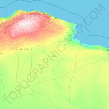
Name: Derna topographic map, elevation, terrain.

Location: Derna, Libya (30.79162 21.91775 33.13895 23.47908)

Average elevation: 157 m

Minimum elevation: -1 m

Maximum elevation: 872 m

Other topographic maps

Click on a map to view its topography, its elevation and its terrain.

Benghazi

Libya

The largest Ottoman architectural monument in Benghazi is the late 19th-century Ottoman palace in El-Berka; built during the rule of Rashid Pasha II. The front elevation was completed in 1895, whilst the side sections were added later during Italian rule. The white and green structure houses 360 rooms; and is…

Average elevation: 23 m

Libyan Desert

Libya > Kufra

Sand plains, dunes, ridges, and some depressions (basins) typify the endorheic region, with no rivers draining into or out of the desert. The Gilf Kebir plateau reaches an altitude of just over 1,000 m (3,300 feet), and along with the nearby massif of Jebel Uweinat is an exception to the uninterrupted…

Average elevation: 566 m

Taghma

Libya > Jabal al Gharbi > Taghma

Average elevation: 256 m

Sawani Bin Adam

Libya > Jafara

Average elevation: 64 m

Al Ajyaylat

Libya > Nuqat al Khams

Average elevation: 23 m

Central Msallata

Libya > Murqub

Average elevation: 190 m

Karkura

Libya > Benghazi

Average elevation: 1 m

Elba island

Libya > Butnan

Average elevation: 78 m

Al Mansura

Libya > Wadi al Shatii

Average elevation: 381 m

Ajdabiya

Libya > Al Wahat

Average elevation: 29 m

WADI BAI

Libya > Sirte

Average elevation: 79 m

Dirj

Libya > Nalut

Average elevation: 434 m

Waddan

Libya > District of Al-Jufra

Average elevation: 304 m

Wadi Ka’am Dam

Libya > Bani Walid

Average elevation: 83 m

aldeesa

Libya > Wadi al Hayaa

Average elevation: 465 m

New Brega

Libya > Al Wahat

Average elevation: 9 m

Al Watya

Libya > Nuqat al Khams

Average elevation: 71 m

Abu Salim

Libya > Tripoli

Average elevation: 25 m

Qabilat Sidi Mu`ammar

Libya > Murqub

Average elevation: 336 m

Shahhat

Libya > Jabal al Akhdar

Average elevation: 565 m

Qatrun

Libya > Murzuq > Qatrun

Average elevation: 471 m

Sidi Khalifa

Libya > Benghazi > Sidi Khalifa

Average elevation: 9 m

aljazeera district

Libya > Bani Walid > Misrata

Average elevation: 16 m

Bardia

Libya > Butnan

Average elevation: 81 m

Zulten

Libya > Nuqat al Khams > Zulten

Average elevation: 8 m

Jaffar

Libya > Jabal al Gharbi > Jaffar

Average elevation: 637 m

Qariat Bashir

Libya > Al Wahat > Qariat Bashir

Average elevation: 12 m

Al Adam

Libya > Butnan > Al Adam

Average elevation: 148 m

Wifat

Libya > Jabal al Gharbi > Wifat

Average elevation: 613 m

Tindbas

Libya > Jabal al Gharbi > Tindbas

Average elevation: 597 m

Temzghurah

Libya > Jabal al Gharbi > Temzghurah

Average elevation: 565 m

Igennawen

Libya > Jabal al Gharbi > Igennawen

Average elevation: 520 m

Awlad `Isa

Libya > Jabal al Gharbi > Awlad `Isa

Average elevation: 689 m

Al Sahqeeqa

Libya > Jabal al Gharbi > Al Sahqeeqa

Average elevation: 595 m

Suknah

Libya > District of Al-Jufra > Suknah

Average elevation: 295 m

Al Fuqaha`

Libya > District of Al-Jufra > Al Fuqaha`

Average elevation: 534 m

Tmassah

Libya > Murzuq > Tmassah

Average elevation: 422 m

Zawilah

Libya > Murzuq > Zawilah

Average elevation: 437 m

Tarbu

Libya > Murzuq > Tarbu

Average elevation: 435 m

Mzwir

Libya > Murzuq > Mzwir

Average elevation: 434 m

Al Bakhi

Libya > Murzuq > Al Bakhi

Average elevation: 477 m

Tajerhi

Libya > Murzuq > Tajerhi

Average elevation: 491 m

Jebel Akhdar

Libya > Jabal al Akhdar

Average elevation: 847 m

dar bin sweedan

Libya > Jafara > Al-Nasiriyya

Average elevation: 94 m

Gabraaun Lake

Libya > Wadi al Hayaa

Average elevation: 491 m

Bab Gorji

Libya > Tripoli > Tripoli

Average elevation: 13 m

Al Kharoba

Libya > Marj

Average elevation: 317 m

Gear up for your next adventure:

👕Technical Hiking Tees - Moisture-management for high-exertion climbs
🔦LED Camping Lanterns - Illumination for reading maps inside your tent at night
🥄Titanium Camping Sporks - The ultimate lightweight utensil for trail meals
🧦Hiking Socks - Breathable socks designed to prevent blisters on long walks
🥤Collapsible Water Bottles - Save space in your rucksack as you consume your water

As an Amazon Associate, this site earns from qualifying purchases at no extra cost to you.