
Quiché topographic map
Interactive map
Click on the map to display elevation.
About this map
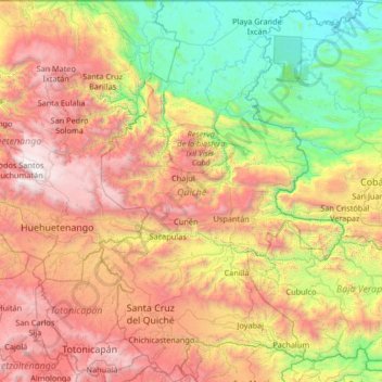
Name: Quiché topographic map, elevation, terrain.
Location: Quiché, Guatemala (14.80193 -91.32723 16.07394 -90.41792)
Average elevation: 1,510 m
Minimum elevation: 124 m
Maximum elevation: 3,815 m
Other topographic maps
Click on a map to view its topography, its elevation and its terrain.
Tikal
The city has been completely mapped and covered an area greater than 16 square kilometres (6.2 sq mi) that included about 3,000 structures. The topography of the site consists of a series of parallel limestone ridges rising above swampy lowlands. The major architecture of the site is clustered upon areas of…
Average elevation: 270 m
San Agustín Acasaguastlán
Guatemala > El Progreso > San Agustín Acasaguastlán
Average elevation: 469 m
Guatemala City
Guatemala > Guatemala Department > Guatemala City > Guatemala City
Average elevation: 1,558 m
Pacaya
Guatemala > Escuintla > San Vicente Pacaya
Pacaya is an active complex volcano in Guatemala, which first erupted approximately 23,000 years ago and has erupted at least 23 times since the Spanish conquest of Guatemala. It rises to an elevation of 2,552 metres (8,373 ft). After being dormant for over 70 years, it began erupting vigorously in 1961 and…
Average elevation: 2,075 m
Panajachel
Guatemala > Sololá > Panajachel
Panajachel (Spanish pronunciation: , Pana) is a town in the southwestern Guatemalan Highlands, less than 90 miles from Guatemala City, in the department of Sololá. It serves as the administrative centre for the surrounding municipality of the same name. The elevation is 1,597 metres (5,240 ft). Population was…
Average elevation: 1,860 m