
Make a donation
Gear up for your next adventure:
As an Amazon Associate, this site earns from qualifying purchases at no extra cost to you.
Chandigarh topographic map
Click on the map to display elevation.
Make a donation
Gear up for your next adventure:
As an Amazon Associate, this site earns from qualifying purchases at no extra cost to you.
Chandigarh
Chandigarh is located by the foothills of the Shivalik Range of the Himalayas in northwest India. It covers an area of approximately 114 km2. It borders the states of Punjab and Haryana. The exact geographic coordinates of Chandigarh are 30°44′N 76°47′E / 30.74°N 76.79°E / 30.74; 76.79. It has an average elevation of 321 metres (1053 ft).
Make a donation
Gear up for your next adventure:
As an Amazon Associate, this site earns from qualifying purchases at no extra cost to you.
About this map
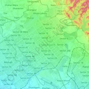
Name: Chandigarh topographic map, elevation, terrain.
Location: Chandigarh, India (30.66497 76.70499 30.79495 76.84903)
Average elevation: 343 m
Minimum elevation: 300 m
Maximum elevation: 511 m
Make a donation
Gear up for your next adventure:
As an Amazon Associate, this site earns from qualifying purchases at no extra cost to you.
Other topographic maps
Click on a map to view its topography, its elevation and its terrain.
Kolkata
Spread roughly north–south along the east bank of the Hooghly River, Kolkata sits within the lower Ganges Delta of eastern India approximately 75 km (47 mi) west of the international border with Bangladesh; the city's elevation is 1.5–9 m (5–30 ft). Much of the city was originally a wetland that was…
Average elevation: 5 m
Agra
India > Uttar Pradesh > Agra
The region around Agra consists almost entirely of a level plain, with hills in the extreme southwest. The rivers in the region include Yamuna and Chambal. The region is also watered by the Agra Canal. Millet, barley, wheat and cotton are among the crops grown in the surrounding countryside. Both Rabi and…
Average elevation: 166 m
Surat
India > Gujarat > Katargam Taluka > Surat
Surat is a port city situated on the banks of the Tapi river. Damming of the Tapi caused the original port facilities to close; the nearest port is now in the Magadalla and Hazira area of Surat Metropolitan Region.It has famous beach called 'Dumas Beach' located in Hazira. The city is located at 21°10′N…
Average elevation: 11 m
Make a donation
Gear up for your next adventure:
As an Amazon Associate, this site earns from qualifying purchases at no extra cost to you.
Pimpri-Chinchwad
India > Maharashtra > Haveli
Pimpri-Chinchwad also known as "PCMC", is a city in the Indian state of Maharashtra. The city is about 15 km (9.3 mi) northwest of the historic city of Pune, at an altitude of 590 m (1,940 ft) above sea level. It is the fifth largest city in Maharashtra and the nineteenth largest city in India and the…
Average elevation: 605 m
Haldwani
India > Uttarakhand > Haldwani
Haldwani is located at 29°13′N 79°31′E / 29.22°N 79.52°E / 29.22; 79.52, in the Nainital district on the right bank of the Gaula River. Geologically, Haldwani is settled on a piedmont grade (called Bhabhar) where the mountain rivers go underground to re-emerge in the Indo-Gangetic plain. The…
Average elevation: 673 m
Make a donation
Gear up for your next adventure:
As an Amazon Associate, this site earns from qualifying purchases at no extra cost to you.
Rishikesh
India > Uttarakhand > Rishikesh
Rishikesh is at 30°06′12″N 78°17′41″E / 30.103368°N 78.294754°E / 30.103368; 78.294754. It has an average elevation of 372 metres (1,220 ft). The town is located in the Tehri Garhwal region of the northern Indian state of Uttarakhand.
Average elevation: 497 m
Almora
India > Uttarakhand > Almora
Almora is located at 29°35′50″N 79°39′33″E / 29.5971°N 79.6591°E / 29.5971; 79.6591 in Almora district in Uttarakhand. Almora is situated 365 km north-east the national capital New Delhi and 415 km south-east the state capital Dehradun. It lies in the revenue Division Kumaon and is located…
Average elevation: 1,557 m
Make a donation
Gear up for your next adventure:
As an Amazon Associate, this site earns from qualifying purchases at no extra cost to you.
Hosur
India > Tamil Nadu > Hosur
Hosur experiences a tropical savanna climate (Köppen climate classification) with distinct wet and dry seasons. Due to its high elevation, Hosur usually enjoys salubrious and moderate climate throughout the year, with occasional heat waves. The coolest month is January with an average low temperature of 17.1…
Average elevation: 859 m
Make a donation
Gear up for your next adventure:
As an Amazon Associate, this site earns from qualifying purchases at no extra cost to you.
Chandigarh
India > Chandigarh > Chandigarh > Chandigarh
Chandigarh is located near the foothills of the Sivalik range of the Himalayas in northwest India. It covers an area of approximately 114 km2. It borders the states of Haryana and Punjab. The exact geographic co-ordinates of Chandigarh are 30°44′N 76°47′E / 30.74°N 76.79°E / 30.74; 76.79. It…
Average elevation: 378 m
Gaya
India > Bihar > Gaya Town C.D.Block
Gaya is connected to the rest of India by roads, rail and airways. The Grand Chord section of the Indian Railways passes through Gaya. Gaya Junction railway station railway station is a major junction station serving the city. Gaya Junction has been redeveloped as Model railway station recently and houses all…
Average elevation: 111 m
Make a donation
Gear up for your next adventure:
As an Amazon Associate, this site earns from qualifying purchases at no extra cost to you.
Shantipur
India > West Bengal > Santipur
Santipur is located at 23°15′N 88°26′E / 23.25°N 88.43°E / 23.25; 88.43. It has an average elevation of 15 metres (49 feet).
Average elevation: 11 m
Vellore Fort
India > Tamil Nadu > Vellore > Vellore
It is mentioned that "there is no such fort on the face of earth like the one in Vellore. It had a deep wet ditch (moat) where once 10,000 crocodiles swarmed, waiting to grab every intruder into this impregnable fort. It has huge double walls with bastions projecting irregularly, where two carts can be driven…
Average elevation: 214 m
Make a donation
Gear up for your next adventure:
As an Amazon Associate, this site earns from qualifying purchases at no extra cost to you.
Make a donation
Gear up for your next adventure:
As an Amazon Associate, this site earns from qualifying purchases at no extra cost to you.
Alnavar
India > Karnataka > Alnavara taluku
Alnavar is located at 15°26′N 74°44′E / 15.43°N 74.73°E / 15.43; 74.73. It has an average elevation of 563 metres (1847 feet). Trains from Bangalore to Vasco da Gama passes through this town.
Average elevation: 575 m
Make a donation
Gear up for your next adventure:
As an Amazon Associate, this site earns from qualifying purchases at no extra cost to you.
Didwana
India > Rajasthan > Didwana Tehsil
Didwana is located at 27°24′N 74°34′E / 27.4°N 74.57°E / 27.4; 74.57. It has an average elevation of 336 metres (1102 feet). City divided in 40 Wards. It is an important station of Jodhpur-Delhi Broad gauge rail route of North West Railway Jodhpur division.
Average elevation: 343 m
Make a donation
Gear up for your next adventure:
As an Amazon Associate, this site earns from qualifying purchases at no extra cost to you.
Make a donation
Gear up for your next adventure:
As an Amazon Associate, this site earns from qualifying purchases at no extra cost to you.
Make a donation
Gear up for your next adventure:
As an Amazon Associate, this site earns from qualifying purchases at no extra cost to you.
Make a donation
Gear up for your next adventure:
As an Amazon Associate, this site earns from qualifying purchases at no extra cost to you.
Pahalgam
India > Jammu and Kashmir > Pahalgam
Pahalgam (Hindustani pronunciation: [pɛhɛlɡaːm]), known as Pahalgom (Kashmiri pronunciation: [pəhəlʲɡoːm]; lit. 'village of shepherds' in Kashmiri) is a town and a notified area committee, near Anantnag city in the Anantnag district of the Indian-administered union territory of Jammu and Kashmir. It…
Average elevation: 2,700 m
Make a donation
Gear up for your next adventure:
As an Amazon Associate, this site earns from qualifying purchases at no extra cost to you.
Make a donation
Gear up for your next adventure:
As an Amazon Associate, this site earns from qualifying purchases at no extra cost to you.
Make a donation
Gear up for your next adventure:
As an Amazon Associate, this site earns from qualifying purchases at no extra cost to you.
Make a donation
Gear up for your next adventure:
As an Amazon Associate, this site earns from qualifying purchases at no extra cost to you.
Solapur
India > Maharashtra > Solapur North
Solapur is located at 17°41′N 75°55′E / 17.68°N 75.92°E / 17.68; 75.92. It has an average elevation of 458 metres (1502 feet). It is bordered by Ahmednagar district on the north; Osmanabad district on the north and northeast.
Average elevation: 469 m
Make a donation
Gear up for your next adventure:
As an Amazon Associate, this site earns from qualifying purchases at no extra cost to you.
Kolukkumalai
India > Tamil Nadu > Bodinayakanur
Kolukkumalai is a small village/hamlet in Bodinayakanur Taluk in the Theni district of the Indian state of Tamil Nadu. It is home to the highest tea plantation in the world with the tea grown here possessing a special flavour and freshness because of the high altitude. It is located near Munnar in Idukki…
Average elevation: 1,726 m
Make a donation
Gear up for your next adventure:
As an Amazon Associate, this site earns from qualifying purchases at no extra cost to you.
Katra
India > Jammu and Kashmir > Reasi
Katra is located at 32°59′N 74°57′E / 32.98°N 74.95°E / 32.98; 74.95. It has an average elevation of 875 metres (2,474 feet). The Banganga River passes through the village.
Average elevation: 993 m
Make a donation
Gear up for your next adventure:
As an Amazon Associate, this site earns from qualifying purchases at no extra cost to you.
Kalavad
India > Gujarat > Kalavad Taluka
Kalavad is located at 22°13′N 70°23′E / 22.22°N 70.38°E / 22.22; 70.38. It has an average elevation of 87 metres (285 feet).
Average elevation: 100 m
Make a donation
Gear up for your next adventure:
As an Amazon Associate, this site earns from qualifying purchases at no extra cost to you.
Make a donation
Gear up for your next adventure:
As an Amazon Associate, this site earns from qualifying purchases at no extra cost to you.
Karakoram Pass
Historically, the high altitude of the pass and the lack of fodder were responsible for the deaths of countless pack animals while the route was notorious for the trail of bones strewn along the way. There is an almost total absence of vegetation on the approaches to the pass.
Average elevation: 5,521 m
Gokak
India > Karnataka > Gokak taluku
Gokak is second biggest city after Belgaum city in Belgaum district and is surrounded by the Western Ghats. The Ghataprabha River, which has water almost throughout the year, is the chief source of agricultural and drinking water for local people living in the surrounding villages. It has an average elevation…
Average elevation: 593 m
Make a donation
Gear up for your next adventure:
As an Amazon Associate, this site earns from qualifying purchases at no extra cost to you.
ChengiCherla Cheruvu aka Pochamma Kunta
India > Telangana > Medipally mandal > Chengicherla
Average elevation: 510 m
Make a donation
Gear up for your next adventure:
As an Amazon Associate, this site earns from qualifying purchases at no extra cost to you.
Make a donation
Gear up for your next adventure:
As an Amazon Associate, this site earns from qualifying purchases at no extra cost to you.
Make a donation
Gear up for your next adventure:
As an Amazon Associate, this site earns from qualifying purchases at no extra cost to you.