
Make a donation
Gear up for your next adventure:
As an Amazon Associate, this site earns from qualifying purchases at no extra cost to you.
Paro District topographic map
Click on the map to display elevation.
Make a donation
Gear up for your next adventure:
As an Amazon Associate, this site earns from qualifying purchases at no extra cost to you.
About this map
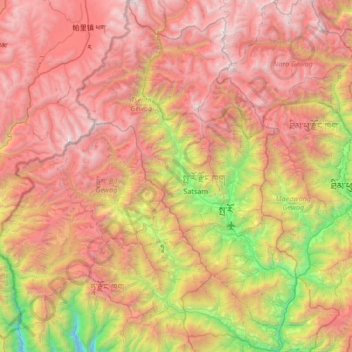
Name: Paro District topographic map, elevation, terrain.
Location: Paro District, Bhutan (27.18834 89.12806 27.78384 89.54903)
Average elevation: 3,704 m
Minimum elevation: 1,646 m
Maximum elevation: 5,692 m
Make a donation
Gear up for your next adventure:
As an Amazon Associate, this site earns from qualifying purchases at no extra cost to you.
Other topographic maps
Click on a map to view its topography, its elevation and its terrain.
Trashiyangtse
Bhutan > Trashiyangtse District > Boomdeling Gewog > Dzongkhag Thromde
Average elevation: 2,273 m
Make a donation
Gear up for your next adventure:
As an Amazon Associate, this site earns from qualifying purchases at no extra cost to you.
Thimphu
Bhutan > Thimphu District > Chang Gewog
The city extends in a north–south direction on the west bank of the valley formed by the Wang Chhu, which flows out into India as the Raidāk River. Thimphu is the fifth highest capital in the world by altitude and ranges in altitude from 2,248 metres (7,375 feet) to 2,648 metres (8,688 feet). Unusually for…
Average elevation: 3,121 m
Make a donation
Gear up for your next adventure:
As an Amazon Associate, this site earns from qualifying purchases at no extra cost to you.
Tala Hydroelectric Power Plant Bhutan
Bhutan > Chukha > Bjagchhog Gewog > Bjagchhog
Average elevation: 1,771 m
Jakar
Bhutan > Bumthang District > Chhoekhor Gewog > Dawathang_Dorjibi_ Kashingtsawa
Average elevation: 2,948 m
Make a donation
Gear up for your next adventure:
As an Amazon Associate, this site earns from qualifying purchases at no extra cost to you.
Rangjung
Bhutan > Trashigang District > Shongphu Gewog > Chhangmi_Rangjoong
Average elevation: 1,654 m
Trongsa
Bhutan > Trongsa District > Nubi Gewog > Bagochen Boolingpang Ueling
Average elevation: 2,585 m
Make a donation
Gear up for your next adventure:
As an Amazon Associate, this site earns from qualifying purchases at no extra cost to you.
Namseling
Bhutan > Thimphu District > Maedwang Gewog > Danglo_Namsaeling > Jamisa
Average elevation: 2,516 m
Namseling
Bhutan > Thimphu District > Maedwang Gewog > Danglo_Namsaeling > Jamisa
Average elevation: 2,516 m
Make a donation
Gear up for your next adventure:
As an Amazon Associate, this site earns from qualifying purchases at no extra cost to you.
Jakar
Bhutan > Bumthang District > Chhoekhor Gewog > Dawathang_Dorjibi_ Kashingtsawa
Average elevation: 2,948 m
Make a donation
Gear up for your next adventure:
As an Amazon Associate, this site earns from qualifying purchases at no extra cost to you.
Tebjikha
Bhutan > Chukha > Bjagchhog Gewog > Tsimakha Tsimashysham > Tsimalakha
Average elevation: 2,237 m
Trongsa
Bhutan > Trongsa District > Nubi Gewog > Bagochen Boolingpang Ueling
Average elevation: 2,585 m
Nobding
Bhutan > Wangdue Phodrang District > Dangchhu Gewog > Doongdoongnyelsa Norbooding
Average elevation: 2,650 m
Nobding
Bhutan > Wangdue Phodrang District > Dangchhu Gewog > Doongdoongnyelsa Norbooding
Average elevation: 2,650 m
Make a donation
Gear up for your next adventure:
As an Amazon Associate, this site earns from qualifying purchases at no extra cost to you.
Make a donation
Gear up for your next adventure:
As an Amazon Associate, this site earns from qualifying purchases at no extra cost to you.
Make a donation
Gear up for your next adventure:
As an Amazon Associate, this site earns from qualifying purchases at no extra cost to you.
Make a donation
Gear up for your next adventure:
As an Amazon Associate, this site earns from qualifying purchases at no extra cost to you.
Wangdue Phodrang Dzongkhag
Bhutan > Wangdue Phodrang District > Wangdue Phodrang Dzongkhag
Average elevation: 3,150 m
Make a donation
Gear up for your next adventure:
As an Amazon Associate, this site earns from qualifying purchases at no extra cost to you.
Thimphu
Bhutan > Thimphu District > Chang Gewog
The city extends in a north–south direction on the west bank of the valley formed by the Wang Chhu, which flows out into India as the Raidāk River. Thimphu is the sixth highest capital in the world by altitude, ranging from 2,248 metres (7,375 feet) to 2,648 metres (8,688 feet). Unlike many capitals,…
Average elevation: 3,121 m
Gomtu
Bhutan > Samtse District > Phuentshogpelri Gewog > Jangchhogling Lachhungthang
Average elevation: 392 m
Make a donation
Gear up for your next adventure:
As an Amazon Associate, this site earns from qualifying purchases at no extra cost to you.
Phongmey
Bhutan > Trashigang District > Phongmed Gewog > Thong-Rong Chiwogs > Phongmey
Average elevation: 2,096 m
Wamrong
Bhutan > Trashigang District > Thrimshing Gewog > Ramchongma_Yemkhar Chiwogs > Wamrong
Average elevation: 1,910 m
Chhusemu Chu
Bhutan > Wangdue Phodrang District > Saephu Gewog > Booso Zeri
Average elevation: 3,129 m
Make a donation
Gear up for your next adventure:
As an Amazon Associate, this site earns from qualifying purchases at no extra cost to you.
Tsimasham
Bhutan > Chukha District > Bjagchhog Gewog > Tsimakha Tsimashysham
Average elevation: 2,512 m
Wet Land
Bhutan > Trongsa District > Nubi Gewog > Bagochen Boolingpang Ueling
Average elevation: 2,195 m